

Pulpit Hill
Good walks are even better shared.
SP8305 : Mud in Pulpit Wood
Des Blenkinsopp Photo source
Overview
Pulpit Hill
Overview
Pulpit Hill, standing at 231 meters, is a striking Marilyn located in the South Downs, ideal for a pleasant day hike or a quick adventure. Its chalky slopes provide both an aesthetic appeal and a chance to observe interesting geology.
Geology
The hill is primarily made of chalk, a sedimentary rock that consists largely of calcium carbonate. This unique geological composition contributes to the landscape's beauty and its biodiversity.
Routes
There are numerous tracks leading to the top, with the most popular being the Southern Circular Trail and the Northern Approach. Whether you fancy a leisurely stroll or a more challenging climb, Pulpit Hill has something for everyone.
Summit Features
Once at the summit, you'll find a trig point standing proudly to mark the high point. Don't forget to take a selfie while you're at it! There’s plenty of space to sit down, enjoy a snack and take in the breathtaking vistas.
Terrain
Expect grassy paths interspersed with rocky patches, especially closer to the summit. Proper footwear is recommended to tackle these parts safely.
Views
Pulpit Hill offers a delightful panorama. Look out for the undulating hills of the South Downs, the distant glimmer of the sea off Brighton, and, with a keen eye, a glimpse of the Isle of Wight. The best time to soak in these vistas is during late spring or early autumn, where the flowers are blooming or the leaves are just starting to turn.
Hazards
Like any adventure, be aware of potential hazards. The chalk paths can be quite slippery, especially when wet. Additionally, the ever-changing British weather can throw a curveball, so it's wise to check ahead and prepare accordingly.
Nearby Summits
For those looking to extend their hike, nearby summits like Channel Hill and Ditchling Beacon provide additional challenges and spectacular views.
Access
Parking
You can park at Pyecombe Golf Club, which is reasonably close and accessible. Just be sure to park considerately!
Public Transport
Buses from bustling Brighton will take you to Pyecombe village, making your hike environmentally friendly!
Nearest Town
Hassocks offers a pleasant stop for pre-or post-hike refreshments, as well as facilities like shops and cafes.
Facilities
While there are no facilities at the top, nearby towns and villages have several options for food and restrooms.
History
The etymology of the name 'Pulpit Hill' brings a whimsical delight, suggesting a preacher's platform. This hill has been pivotal in local folklore, acting as a guiding light for those navigating the landscape.
In summary, Pulpit Hill is not just a hike; it's an experience steeped in natural beauty, history, and just enough challenges to keep you on your toes. Grab your walking boots and get out there!
Explore routes near Pulpit Hill
Walks starting near this hill. Open a route to check its map, distance and full itinerary.
Coombe Hill Monument and Ridgeway Circuit
View route
Wendover Woods Firecrest Trail
View route
Hughenden German Forest and Echo Valley Circuit
View route
Cowleaze Wood Halifax Crash Memorial Circuit
View route
Route planning notes
These notes describe possible approaches. Check a route's map and access information when planning your walk.
Southern Circular Trail
A well-marked path that loops around Pulpit Hill, offering panoramic views and a gentle ascent.
Northern Approach
A direct ascent from the north, this route is more challenging but rewards with stunning vistas from the summit.
Make a day of it, together
Find someone to share the walk with, or organise a day out along a route you like.
Photo Gallery
View all Photo could not load
SP8305 : Mud in Pulpit Wood
Des Blenkinsopp
 Photo could not load
SP8304 : Fence around the Fort
Des Blenkinsopp
 Photo could not load
SP8305 : Strange Tree in Pulpit Wood
Des Blenkinsopp
Hill facts and local notes
Classifications
Elevation
248m
814 ft
Prominence
55m
Coordinates
51.7382, -0.7966
SP831050
OS Map
165
Explorer: 181
At the Summit
The summit features a prominent trig point and an observation platform, ideal for the postcard-perfect photo (or several!).
Terrain & Geology
Pulpit Hill is primarily composed of chalk, which is a type of limestone formed from the skeletal remains of marine organisms. The soil here is shallow and thin, which can make the terrain slightly slippery in wet conditions.
Views & Scenery
From the summit, you can see the rolling hills of the South Downs, the city of Brighton, and on a clear day, even the Isle of Wight in the distance.
History & Heritage
Name Origin
The name 'Pulpit Hill' is thought to be derived from its resemblance to a preacher's pulpit, as it rises starkly above the surrounding landscape.
Historical Significance
The hill has been a landmark for centuries and features prominently in local folklore.
Getting There & Facilities
Parking
Parking is available at the Pyecombe Golf Club, approximately 1.5 km from the trailhead. Please park respectfully.
Public Transport
Regular bus services run from Brighton to Pyecombe village, where you can start your hike.
Nearby Facilities
There are no facilities at the summit, but nearby Hassocks and Pyecombe offer cafes and public toilets.
Safety Information
Known Hazards
- Be cautious of slippery chalk paths after rain. Also, keep an eye out for sudden changes in weather, as they can arise quickly in this region.
General Safety Tips
- Check weather conditions before setting out
- Carry appropriate clothing and equipment
- Let someone know your planned route
- Take a map, compass, and GPS device
- Carry emergency supplies: food, water, first aid kit, torch
Hills
Some common questions about the hills answered
Are there group walks up Pulpit Hill?
Many walkers use Walkmates to join or organise walks with others. You can check for group walks around Pulpit Hill through the maps
Are there other walkers around Pulpit Hill?
Activity varies by location and time, but Walkmates lets you see whether others have shared walks or shown interest in this area. Find other people through the walking friends search walking friends for Pulpit Hill search or of course create your own walk for Pulpit Hill
Can I organise a walk to Pulpit Hill?
Yes. If there aren’t any walks listed already, you can create a walk and make it available for others to join.
If you're signed up to Walkmates, you can create a walk to Pulpit Hill.
How do I find a walk up this hill?
There are often multiple ways to walk this hill, depending on experience and route preference. Walkmates helps you explore walks and routes that others have shared.
Can I suggest a new route up Pulpit Hill?
Yes. You can suggest or create routes to share with others. Walkmates focuses on the social side of walking, so routes are used to help people organise walks and explore areas together, rather than as detailed navigation tools or route libraries.
Other uses really appreciate knowledgeable walkers sharing their routes. Share your favourite route to Pulpit Hill here
The is an error or something incorrect about this hill. How do I let you know?
We always strive to keep the information on Walkmates as accurate as possible. If you find an error, please let us know through the contact form and we'll aim to correct it as quickly as possible
Community Discussion
Comments
Location
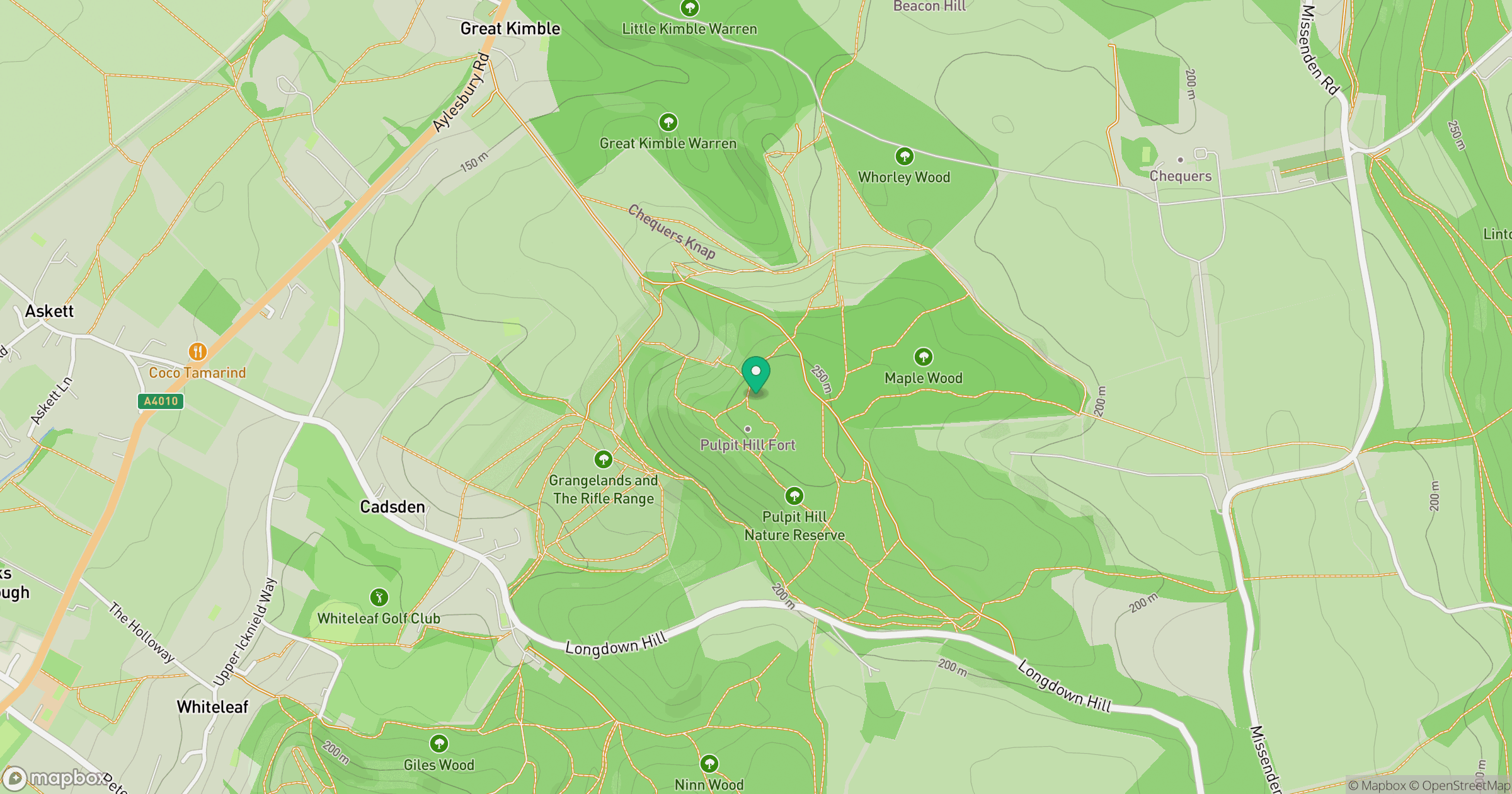
Grid reference: SP831050
View on OpenStreetMapOpens a map in a new tab, centred on the hill.
Nearby Hills
Leith Hill
294m
Ditchling Beacon
248m
Worcestershire Beacon
425m
The Roaches
505m
Titterstone Clee Hill
533m
No comments yet. Be the first.