
Coombe Hill
Good walks are even better shared.
Overview
Coombe Hill is a 260 m Hump on the Chiltern escarpment above the Vale of Aylesbury, near Wendover in Buckinghamshire. Chalk grassland, heath and beech woodland surround its well-known Boer War memorial. The unmarked natural high point lies 110 m south-south-east of the memorial; wooded ground to the east may be equally high.
Coombe Hill
Summit and setting
Coombe Hill near Wendover is a 260 m Hump with 108 m of prominence. DoBIH places its unmarked natural high point at SP849066, 110 m south-south-east of the Boer War memorial, and notes that wooded ground to the east could be as high. The memorial is a separate viewpoint landmark. Coombe Hill is not the Chilterns’ highest hill: nearby Wendover Woods (Haddington Hill) reaches 267.5 m.
Walking routes
Coombe Hill woodland circuit
From Coombe Hill car park (SP851062), pass through Low Scrubs, Dunsmore and Linton’s Wood, then return via the Ridgeway and memorial to the car park. National Trust: 90–120 minutes for the complete 5.6 km circuit. Uneven woodland paths can be muddy; a short section follows a lane. The published circuit visits the memorial area, not a measured detour to the unmarked natural summit.
Best of Coombe Hill circular walk
Follow the orange-waymarked National Trust circuit from Coombe Hill car park via the memorial, returning along the grassy Ridgeway and back to the car park. The complete 1.6 km circuit takes 40 minutes. Wheelchair and pushchair users should return along the outward gravel path instead; the full circuit is foot-only. The memorial is distinct from the natural summit.
Coombe Hill from Wendover circuit
From Wendover, cross the A413 by the road bridge, then use lanes and woodland paths to reach Coombe Hill car park and the memorial. Return via the Ridgeway over Bacombe Hill to Wendover. Walking Britain walk 3345 gives 6.5 km, 136 m ascent and 140 minutes for the complete circuit. This itinerary visits the memorial area, not a measured natural-summit detour.
Access and facilities
The National Trust car park is on Lodge Hill at SP851062 (HP17 0UR), with free parking and picnic seating. There are no toilets or café on site. Wendover has public toilets and refreshments. From Wendover station, the Ridgeway/Bacombe Hill approach to the memorial is about 1.5 miles one way. Consult Red Group’s current timetable before planning a bus approach via Butlers Cross.
Terrain and safety
Gravel paths give way to grassy and uneven woodland sections. Rain makes the paths muddy or slippery, and the Ridgeway can be slippery in ice. Keep dogs on leads around grazing cattle. The woodland circuit has uneven footpaths and a short lane section. The Wendover circuit includes road walking and crossings; use the road bridge over the A413.
Landscape and history
The chalk escarpment passes into clay-with-flints and other deposits on the plateau, supporting chalk grassland, acid grassland, heath and scrub within the Bacombe and Coombe Hills SSSI. Low Scrubs contains old coppiced beech woodland. The Grade II stone memorial commemorates Buckinghamshire’s South African War dead; it was erected in 1904 and rebuilt in 1938 after lightning damage. Views extend over the Vale of Aylesbury and along the Chiltern escarpment, with Chequers below and the Cotswolds visible in clear conditions.
Sources
Explore routes near Coombe Hill
Walks starting near this hill. Open a route to check its map, distance and full itinerary.
Coombe Hill Monument and Ridgeway Circuit
View route
Wendover Woods Firecrest Trail
View route
Aylesbury Walk with Men Walking & Talking
View route
Hughenden German Forest and Echo Valley Circuit
View route
Route planning notes
These notes describe possible approaches. Check a route's map and access information when planning your walk.
Coombe Hill woodland circuit
From Coombe Hill car park (SP851062), pass through Low Scrubs, Dunsmore and Linton’s Wood, then return via the Ridgeway and memorial to the car park. National Trust: 90–120 minutes for the complete 5.6 km circuit. Uneven woodland paths can be muddy; a short section follows a lane. The published circuit visits the memorial area, not a measured detour to the unmarked natural summit.
Best of Coombe Hill circular walk
Follow the orange-waymarked National Trust circuit from Coombe Hill car park via the memorial, returning along the grassy Ridgeway and back to the car park. The complete 1.6 km circuit takes 40 minutes. Wheelchair and pushchair users should return along the outward gravel path instead; the full circuit is foot-only. The memorial is distinct from the natural summit.
Coombe Hill from Wendover circuit
From Wendover, cross the A413 by the road bridge, then use lanes and woodland paths to reach Coombe Hill car park and the memorial. Return via the Ridgeway over Bacombe Hill to Wendover. Walking Britain walk 3345 gives 6.5 km, 136 m ascent and 140 minutes for the complete circuit. This itinerary visits the memorial area, not a measured natural-summit detour.
Make a day of it, together
Find someone to share the walk with, or organise a day out along a route you like.
Hill facts and local notes
Classifications
Elevation
260m
853 ft
Prominence
108m
Coordinates
51.7521, -0.7710
SP849066
OS Map
165
Explorer: 181
At the Summit
DoBIH records an unmarked natural high point at SP849066, 110 m south-south-east of the Boer War memorial; wooded ground to the east could be equally high. The stone memorial is a viewpoint landmark, not the recorded summit feature or a trig point.
Terrain & Geology
Bacombe and Coombe Hills expose the transition from chalk on the escarpment to clay-with-flints and other plateau deposits. This supports a mix of chalk grassland, acid grassland, heath and scrub.
Views & Scenery
The memorial viewpoint overlooks the Vale of Aylesbury and the Chiltern escarpment. Chequers is visible from the hillside paths; in clear conditions the National Trust describes views as far as the Cotswolds.
Best Seasons
Summer brings chalk-grassland wildflowers and butterflies. Low Scrubs has spring bluebells and beech woodland autumn colour.
History & Heritage
Historical Significance
The stone Boer War memorial was erected in 1904 and rebuilt in 1938 after a lightning strike. It commemorates Buckinghamshire men who died in the South African War of 1899–1902 and is Grade II listed. Low Scrubs was common woodland where villagers coppiced beech for fuel.
Getting There & Facilities
Parking
National Trust Coombe Hill car park on Lodge Hill, near Butlers Cross (SP851062; HP17 0UR). Parking is listed as free. This is a hilltop-area car park, reached from Missenden Road via Lodge Hill.
Public Transport
Wendover station is on the Chiltern Railways line. The National Trust describes a 1.5-mile walk from the station via the Ridgeway and Bacombe Hill to the memorial; this is an approach distance, not a return circuit. For a bus approach via Butlers Cross, consult Red Group’s current timetable for the stop and return service before travelling.
Nearby Facilities
Picnic seating is available by the Coombe Hill car park and on the hill. There are no toilets or café on site; Wendover has public toilets and places to eat.
Safety Information
Known Hazards
- The grassy Ridgeway and woodland paths can be muddy or slippery after rain; ice makes the Ridgeway section particularly slippery.
- Cattle graze Coombe Hill. Keep dogs on leads and leave gates as found.
- The woodland circuit includes uneven footpaths and a short lane section. The Wendover circuit includes road walking and crossings; use the road bridge over the A413.
- The full short circuit has a grassy, foot-only return. Wheelchair and pushchair users should return from the memorial along the outward gravel path.
Seasonal Hazards
Wet weather can leave woodland paths muddy and the grassy Ridgeway slippery; the short circuit’s Ridgeway section can also be slippery in ice. Cattle graze the site in summer.
General Safety Tips
- Check weather conditions before setting out
- Carry appropriate clothing and equipment
- Let someone know your planned route
- Take a map, compass, and GPS device
- Carry emergency supplies: food, water, first aid kit, torch
Hills
Some common questions about the hills answered
Are there group walks up Coombe Hill?
Many walkers use Walkmates to join or organise walks with others. You can check for group walks around Coombe Hill through the maps
Are there other walkers around Coombe Hill?
Activity varies by location and time, but Walkmates lets you see whether others have shared walks or shown interest in this area. Find other people through the walking friends search walking friends for Coombe Hill search or of course create your own walk for Coombe Hill
Can I organise a walk to Coombe Hill?
Yes. If there aren’t any walks listed already, you can create a walk and make it available for others to join.
If you're signed up to Walkmates, you can create a walk to Coombe Hill.
How do I find a walk up this hill?
There are often multiple ways to walk this hill, depending on experience and route preference. Walkmates helps you explore walks and routes that others have shared.
Can I suggest a new route up Coombe Hill?
Yes. You can suggest or create routes to share with others. Walkmates focuses on the social side of walking, so routes are used to help people organise walks and explore areas together, rather than as detailed navigation tools or route libraries.
Other uses really appreciate knowledgeable walkers sharing their routes. Share your favourite route to Coombe Hill here
The is an error or something incorrect about this hill. How do I let you know?
We always strive to keep the information on Walkmates as accurate as possible. If you find an error, please let us know through the contact form and we'll aim to correct it as quickly as possible
Community Discussion
Comments
Location
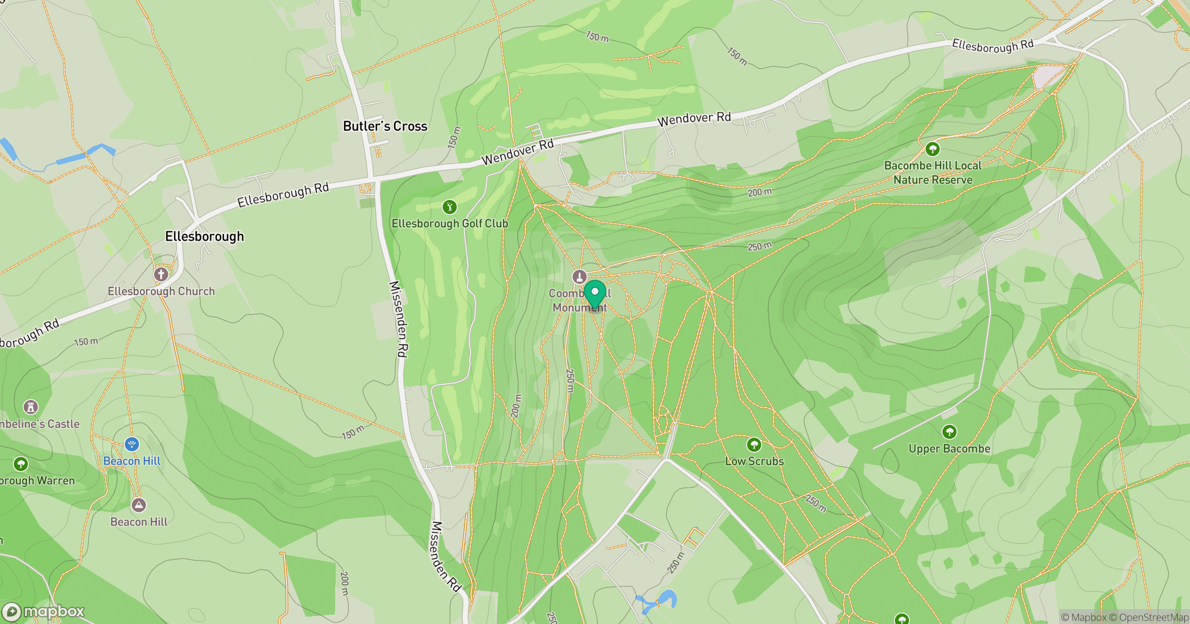
Grid reference: SP849066
View on OpenStreetMapOpens a map in a new tab, centred on the hill.
Nearby Hills
Leith Hill
294m
Ditchling Beacon
248m
Worcestershire Beacon
425m
The Roaches
505m
Titterstone Clee Hill
533m
No comments yet. Be the first.