
Ashley Hill
Good walks are even better shared.
Overview
Exploring Ashley Hill
Nestled in the heart of the enchanting Cotswolds, Ashley Hill is a delightful little gem for hikers and nature enthusiasts alike. Standing at an elevation of 123 meters, it offers splendid views without the strenuous effort often associated with towering peaks.
Geology
Constructed mostly from limestone, the hill’s geological features reveal a fascinating history. If you’re lucky, you might even stumble upon some fossils from creatures that lived millions of years ago. So keep your eyes peeled!
Routes
With routes varying in length and difficulty, Ashley Hill caters to all types of walkers. The Ashley Hill Circular Walk is perhaps the most delightful. Stretching about 5 km and taking around 1.5 hours, this moderate trek allows you to wander through beautiful woodlands and past quaint fields. If you’re feeling a bit more adventurous, then the North Face Ascent will challenge you with its steep climbs, perfect for those who prefer to break a sweat.
Summit Features
At the summit, you’ll be greeted by a charming stone cairn and a bench that invites you to sit down, catch your breath, and enjoy the panoramic views. You might find yourself contemplating life’s great mysteries or just how far you can roll down the grassy slopes!
Terrain Type
The terrain is mainly grassy, with occasional rocky patches thrown in for good measure. Be prepared for a bit of mud if the sky decides to open up and share some rain!
Views
The views from Ashley Hill are nothing short of spectacular. On a clear day, look out to the charming villages that dot the landscape and the rolling hills that stretch into the distance. It’s the kind of vista that makes you want to whip out your camera and capture the moment, lest it fade into memory.
Hazards
As always, caution is key. Beware of loose stones, especially on the steeper paths. And remember, mud can make for amusing slides, but safety first!
Access
Accessing Ashley Hill is simple with a parking area located conveniently at the base in Chipping Campden. The village itself is charming and offers various public transport options, making this hill an easy destination to reach.
Nearby Facilities
After your hike, indulge in some well-deserved treats and refreshments at one of the cafés or pubs in Chipping Campden. You might find you’ve earned that slice of cake!
Conclusion
Whether you’re young, old, or just young at heart, Ashley Hill promises a rewarding experience with its stunning views, accessible routes, and the gentle charm of the Cotswolds. Grab your hiking boots and don’t forget your sense of adventure!
Enjoy your adventure on Ashley Hill!
Explore routes near Ashley Hill
Public walks starting within 80 km of this hill. Nearby does not mean a route reaches the summit; check its map and access before setting out.
Woolley Firs small-mammal talk and walk
View route
Henley and Hambleden Lock Thames Path Walk
View route
Cookham, Cock Marsh and Winter Hill
View route
Cliveden Woodland and Duke of Sutherland Viewpoint
View route
Route planning notes
These notes describe possible approaches, not verified navigable routes or permission to cross land. Check current paths, local access rules and conditions before setting out.
Ashley Hill Circular Walk
A pleasant circular route starting from the nearby village, offering a mix of woodland and open fields.
North Face Ascent
A more direct route that climbs steeply from the north, suitable for those looking for a bit of a challenge.
Make a day of it, together
Find someone to share the walk with, or organise a day out along a route you like.
Hill facts and local notes
Classifications
Elevation
145m
476 ft
Prominence
107m
Coordinates
51.5225, -0.8140
SU823810
OS Map
175
Explorer: 172
At the Summit
The summit features a small stone cairn and a picturesque bench, perfect for taking a breather and enjoying the surroundings.
Terrain & Geology
The hill is predominantly composed of limestone, which contributes to its steep escarpments and rich biodiversity. Fossils can often be found embedded in the rock, a delightful surprise for geology enthusiasts.
Views & Scenery
From the top, one can feast their eyes on the stunning vistas of the rolling Cotswolds, with sweeping views of the nearby villages and lush farmland.
History & Heritage
Name Origin
The name 'Ashley' derives from the Old English meaning 'ash tree clearing', hinting at the woodland that once dominated the area.
Historical Significance
Ashley Hill has been a local landmark for centuries and is a popular spot for both locals and tourists seeking a taste of the Cotswolds' beauty.
Getting There & Facilities
Check current local access restrictions, parking rules and transport timetables before travelling. These notes do not confirm public access to the summit.
Parking
There is a small parking area at the base of the hill in the village of Chipping Campden, which is usually free for visitor use.
Public Transport
The nearest bus stop is located in Chipping Campden, with regular services from nearby towns, making it quite accessible.
Nearby Facilities
Cafés and pubs are plentiful in Chipping Campden, with public toilets available near the market square.
Safety Information
Known Hazards
- Loose stones on steeper sections can pose a risk of slips. Attention is advised on wet days.
General Safety Tips
- Check weather conditions before setting out
- Carry appropriate clothing and equipment
- Let someone know your planned route
- Take a map, compass, and GPS device
- Carry emergency supplies: food, water, first aid kit, torch
Hills
Some common questions about the hills answered
Are there group walks up Ashley Hill?
Many walkers use Walkmates to join or organise walks with others. You can check for group walks around Ashley Hill through the maps
Are there other walkers around Ashley Hill?
Activity varies by location and time, but Walkmates lets you see whether others have shared walks or shown interest in this area. Find other people through the walking friends search walking friends for Ashley Hill search or of course create your own walk for Ashley Hill
Can I organise a walk to Ashley Hill?
Yes. If there aren’t any walks listed already, you can create a walk and make it available for others to join.
If you're signed up to Walkmates, you can create a walk to Ashley Hill.
How do I find a walk up this hill?
There are often multiple ways to walk this hill, depending on experience and route preference. Walkmates helps you explore walks and routes that others have shared.
Can I suggest a new route up Ashley Hill?
Yes. You can suggest or create routes to share with others. Walkmates focuses on the social side of walking, so routes are used to help people organise walks and explore areas together, rather than as detailed navigation tools or route libraries.
Other uses really appreciate knowledgeable walkers sharing their routes. Share your favourite route to Ashley Hill here
The is an error or something incorrect about this hill. How do I let you know?
We always strive to keep the information on Walkmates as accurate as possible. If you find an error, please let us know through the contact form and we'll aim to correct it as quickly as possible
Community Discussion
Comments
Location
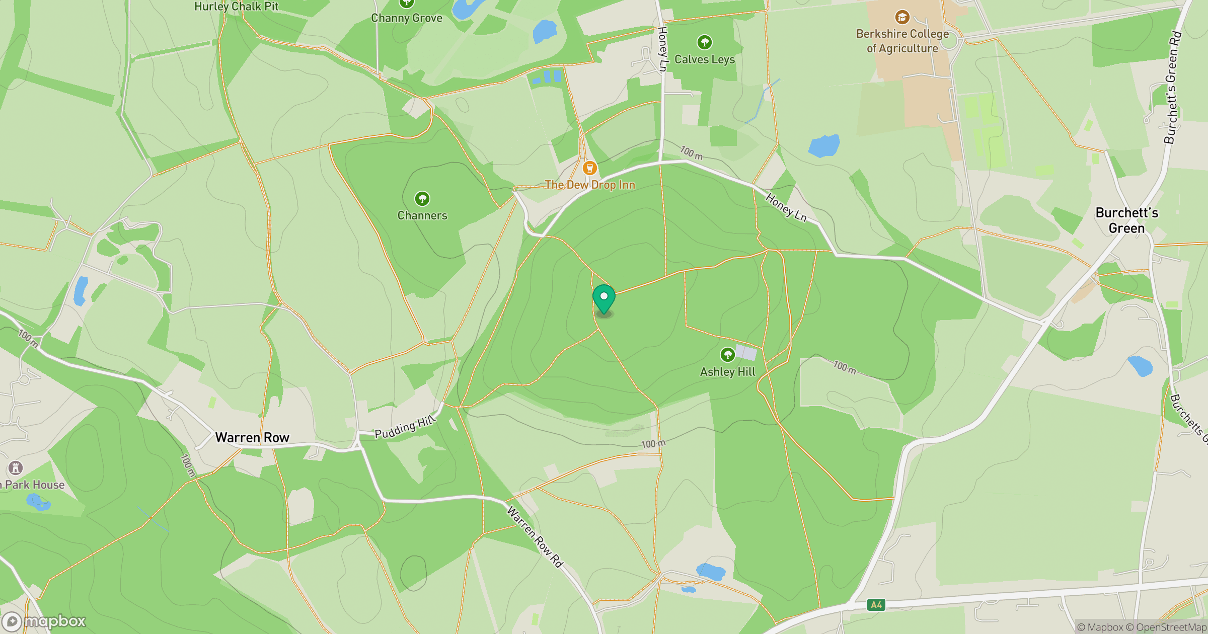
Grid reference: SU823810
View on OpenStreetMapOpens a map in a new tab, centred on the hill.
Hills within 30 km
Straight-line distance, not a walking route or confirmation of access.
No comments yet. Be the first.