

Mynydd Rhiw
Good walks are even better shared.
SH2229 : Gorse covered slopes of Mynydd Rhiw
Eric Jones Photo source
Overview
Mynydd Rhiw is a 304.9 m Marilyn above Rhiw on the Llŷn Peninsula. Its highest rocks lie just south of the trig pillar, with views over Porth Neigwl and towards Eryri in clear weather. The hill has volcanic and igneous ridges, prehistoric stone-working sites and Bronze Age cairns. Short summit approaches and a longer coastal circuit involve uneven ground and exposed weather.
Mynydd Rhiw
Mynydd Rhiw is a 304.9 m Marilyn on the Llŷn Peninsula in Gwynedd, above Rhiw and Porth Neigwl. Its prominence is 239.5 m. The high point is the rocks 3 m south of the trig pillar at SH 22850 29392. DoBIH’s 5 cm comparison refers to the flush bracket on the pillar, not its top.
Landscape, geology and archaeology
The rocky ridge gives clear-weather views across Porth Neigwl and towards Eryri. Mynydd y Graig and Mynydd Penarfynydd are separate ridges farther south. Clip y Gylfinhir is the distinct southern prominence associated with radar/radio equipment.
Hard volcanic and igneous rocks are interspersed with sedimentary layers. BGS identifies the Mynydd Rhiw Rhyolitic Tuff Member and doleritic sills in the local Ordovician sequence.
Prehistoric extraction and tool-making left quarry pits, hollows and waste. RCAHMW reports visits around 3650–3050 BC and favours mainly local supply, rather than extensive long-distance trade. The evidence does not establish continuous production throughout that period. Bronze Age cairns and historic boundaries also survive. Do not move stones, build shelters in cairns or disturb archaeological features. Later manganese mining at Benallt and Nant left remains in the wider landscape; old workings are not places to enter.
Summit routes
Southern road-end out-and-back
Start and finish at the southern road end, 52.824863, -4.635782. Follow the northbound track uphill towards the summit mast, then leave the access line for the rocky trig-point area and the highest rocks 3 m south of the pillar. Return along the same approach to the road end. Richard M1HAX recorded 2.0 km and 80 m ascent on 19 September 2025. Roadside space is informal and very limited: obey signs and keep gates and the mast service road clear.
Llanfaelrhys coastal and summit circuit
Start and finish at the rough Llanfaelrhys lay-by, SH212269. Follow the Coast Path through Penarfynydd farm to the headland trig, then the ridge and coastal path below Mynydd y Graig. Climb into Rhiw, take the signed footpath and tracks north, cross the wall stile near SH230291 and reach Mynydd Rhiw’s trig pillar, the summit point visited by the published itinerary. Make a tiny extra visit to the highest rocks 3 m south of the pillar, then return to the trig area. Rejoin the mast access track towards Clip y Gylfinhir, fork at SH227288 and cross the stone stile at SH223286. Descend the rough western pasture to the waymarked gate and walled lane. Turn left on the road, immediately right, then straight over the crossroads towards Porth Ysgo to regain the lay-by. Happy Hiker’s whole coastal circuit including the trig pillar was walked on 12 May 2015 and is listed as 7.3 miles, approximately 11.7 km. The western descent was vague and gorse-obstructed; use the full guide, current map and signs, and check parking and access.
Separate lower-level walks
The National Trust’s Plas yn Rhiw and Rhiw village walk is a 3.68 km base circuit taking about an hour. It goes through woodland and Rhiw village and returns by lanes. Gwynedd’s different Rhiw Circular Walk is 4.3 km and about two hours, following the south-eastern hillside through fields, lanes and woodland. Neither reaches the summit, and their metrics must not be applied to a summit ascent.
Access, facilities and safety
The short southern summit walk was recorded from the road end at 52.824863, -4.635782 in September 2025. Its author described very limited verge space; this is not a verified formal car park. Keep gates and the mast service road clear and obey current signs. Happy Hiker’s longer circuit started at a rough Llanfaelrhys lay-by, SH212269, in 2015; availability and permission need checking. Plas yn Rhiw visitor parking, SH237282 in the National Trust guide, serves the separate lower village walk.
Gwynedd’s current bus index links Berwyn routes 17/17B between Pwllheli and Aberdaron; the 17B variation serves Rhiw. The linked timetable is effective from 12 April 2021, so check the operator or Traveline for your travel date, stop and return journey. Do not assume Sunday service or a bus to the summit trailhead.
Plas yn Rhiw below the hill has toilets and a tea-room; check opening times before relying on them. The house remains closed throughout the 2026 season for essential restoration, which does not establish a closure of the hill. Carry water and food for the summit routes; the longer Llanfaelrhys circuit has no facilities identified by its route author.
Expect uneven paths, gates and stiles, slippery rock and grass after rain, and exposed wind or poor visibility. The longer circuit adds coastal slopes, several track junctions and a rough descent through gorse. Take care on road sections, give livestock space and follow local dog-lead requirements. Check current signs and access notices before setting out.
Sources and dates
Research checked 17 October 2026. DoBIH row revision, source publication dates and actual walk dates are distinct. The catalogue’s imported revision is retained; the source row used for factual corrections is DoBIH v18.6, record 1955, revision 23 February 2025, with no physical survey date inferred.
Explore routes near Mynydd Rhiw
Walks starting near this hill. Open a route to check its map, distance and full itinerary.
Yr Eifl and the Gyrns guided mountain walk
View route
Northern Rhinogydd guided mountain walk
View route
Beddgelert Forest: Llyn Llywelyn Woodland Circuit
View route
Beddgelert Forest: Derwen Circuit and Llyn Llywelyn
View route
Route planning notes
These notes describe possible approaches. Check a route's map and access information when planning your walk.
Southern road-end summit out-and-back
Start and finish at the southern road end, 52.824863, -4.635782. Follow the northbound track uphill towards the summit mast, then leave the access line for the rocky trig-point area and the highest rocks 3 m south of the pillar. Return along the same approach to the road end. Richard M1HAX recorded 2.0 km and 80 m ascent on 19 September 2025. Roadside space is informal and very limited: obey signs and keep gates and the mast service road clear.
Llanfaelrhys, Penarfynydd and summit circuit
Start and finish at the rough Llanfaelrhys lay-by, SH212269. Follow the Coast Path through Penarfynydd farm to the headland trig, then the ridge and coastal path below Mynydd y Graig. Climb into Rhiw, take the signed footpath and tracks north, cross the wall stile near SH230291 and reach Mynydd Rhiw’s trig pillar, the summit point visited by the published itinerary. Make a tiny extra visit to the highest rocks 3 m south of the pillar, then return to the trig area. Rejoin the mast access track towards Clip y Gylfinhir, fork at SH227288 and cross the stone stile at SH223286. Descend the rough western pasture to the waymarked gate and walled lane. Turn left on the road, immediately right, then straight over the crossroads towards Porth Ysgo to regain the lay-by. Happy Hiker’s whole coastal circuit including the trig pillar was walked on 12 May 2015 and is listed as 7.3 miles, approximately 11.7 km. The western descent was vague and gorse-obstructed; use the full guide, current map and signs, and check parking and access.
Make a day of it, together
Find someone to share the walk with, or organise a day out along a route you like.
Photo Gallery
View all Photo could not load
SH2229 : Gorse covered slopes of Mynydd Rhiw
Eric Jones
 Photo could not load
SH2229 : Mynydd Rhiw radio relay mast
Steve Daniels
 Photo could not load
SH2229 : Radio Mast, Mynydd Rhiw
Chris Andrews
 Photo could not load
SH2229 : Gorsaf drosglwyddo YWA Mynydd Rhiw MOD radio relay station
Eric Jones
 Photo could not load
SH2229 : The trig point and the radio mast on Mynydd Rhiw
David Medcalf
 Photo could not load
SH2229 : Mynydd Rhiw Radio Relay Mast (detail)
Eric Jones
 Photo could not load
SH2229 : The Mynydd Rhiw relay station from the south
Eric Jones
 Photo could not load
SH2229 : Mynydd Rhiw from Llanfaelrhys
Eirian Evans
 Photo could not load
SH2229 : Approaching the top of Mynydd Rhiw
Gordon Hatton

SH2229 : Trigpoint and Tower (Mast), Mynydd Rhiw
Brian Deegan
Hill facts and local notes
Classifications
Elevation
305m
1,000 ft
Prominence
240m
Coordinates
52.8328, -4.6312
SH228293
OS Map
123
Explorer: 253
At the Summit
The summit is the rocks 3 m south of the trig pillar, at SH 22850 29392. DoBIH records their top as 5 cm above the flush bracket, meaning the benchmark on the pillar, not its top. The hill reaches 304.9 m. Nearby radio structures and the separate radar prominence of Clip y Gylfinhir are not the summit.
Terrain & Geology
Hard volcanic and igneous ridges are interspersed with finer sedimentary rocks. The British Geological Survey identifies the Mynydd Rhiw Rhyolitic Tuff Member and doleritic sills within the local Ordovician sequence. Fine-grained baked shaley rock was exploited for prehistoric stone tools. Mynydd Penarfynydd has its own layered igneous intrusion farther south; its geology should not be assigned wholesale to Mynydd Rhiw. Old workings are not walking destinations or permission to enter mines.
Views & Scenery
Views include Porth Neigwl, the surrounding Llŷn countryside and the mountains of Eryri in clear weather. Mynydd y Graig and Mynydd Penarfynydd are separate ridges to the south.
History & Heritage
Historical Significance
Neolithic people extracted stone here for tools, leaving pits, hollows and manufacturing waste. RCAHMW reports radiocarbon evidence for visits around 3650–3050 BC and interprets the output as mainly supplying local needs rather than extensive long-distance trade. Bronze Age cairns and old boundaries survive on the mountain. Later manganese mining at Benallt and Nant left transport and industrial remains in the surrounding landscape. Do not disturb archaeological stonework or enter old mine workings.
Getting There & Facilities
Parking
The short southern summit walk was recorded from the road end at 52.824863, -4.635782 in September 2025. Its author described very limited verge space; this is not a verified formal car park. Keep gates and the mast service road clear and obey current signs. Happy Hiker’s longer circuit started at a rough Llanfaelrhys lay-by, SH212269, in 2015; availability and permission need checking. Plas yn Rhiw visitor parking, SH237282 in the National Trust guide, serves the separate lower village walk.
Public Transport
Gwynedd’s current bus index links Berwyn routes 17/17B between Pwllheli and Aberdaron; the 17B variation serves Rhiw. The linked timetable is effective from 12 April 2021, so check the operator or Traveline for your travel date, stop and return journey. Do not assume Sunday service or a bus to the summit trailhead.
Nearby Facilities
Plas yn Rhiw below the hill has toilets and a tea-room; check opening times before relying on them. The house remains closed throughout the 2026 season for essential restoration, which does not establish a closure of the hill. Carry water and food for the summit routes; the longer Llanfaelrhys circuit has no facilities identified by its route author.
Safety Information
Known Hazards
- Uneven paths, rocky summit ground and steep grassy sections can be slippery after rain.
- Wind and low cloud affect the exposed summit; carry a map and identify the return route.
- The longer coastal circuit has multiple track junctions, stiles and a rough western descent through dwarf gorse. Its published directions date from 2015.
- The Penarfynydd coastal section has exposed slopes and edges. Stay on established paths and keep away from drops.
- Take care on narrow lanes and road crossings. Keep gates and transmitter service access clear.
- Grazing animals and nesting birds need space. Keep dogs close and follow local lead requirements; the National Trust village walk requires leads.
Seasonal Hazards
Rain can make paths muddy and summit rocks slippery. Wind and poor visibility can occur in any season. Check local access notices before walking, and avoid disturbing grazing animals and nesting birds.
General Safety Tips
- Check weather conditions before setting out
- Carry appropriate clothing and equipment
- Let someone know your planned route
- Take a map, compass, and GPS device
- Carry emergency supplies: food, water, first aid kit, torch
Hills
Some common questions about the hills answered
Are there group walks up Mynydd Rhiw?
Many walkers use Walkmates to join or organise walks with others. You can check for group walks around Mynydd Rhiw through the maps
Are there other walkers around Mynydd Rhiw?
Activity varies by location and time, but Walkmates lets you see whether others have shared walks or shown interest in this area. Find other people through the walking friends search walking friends for Mynydd Rhiw search or of course create your own walk for Mynydd Rhiw
Can I organise a walk to Mynydd Rhiw?
Yes. If there aren’t any walks listed already, you can create a walk and make it available for others to join.
If you're signed up to Walkmates, you can create a walk to Mynydd Rhiw.
How do I find a walk up this hill?
There are often multiple ways to walk this hill, depending on experience and route preference. Walkmates helps you explore walks and routes that others have shared.
Can I suggest a new route up Mynydd Rhiw?
Yes. You can suggest or create routes to share with others. Walkmates focuses on the social side of walking, so routes are used to help people organise walks and explore areas together, rather than as detailed navigation tools or route libraries.
Other uses really appreciate knowledgeable walkers sharing their routes. Share your favourite route to Mynydd Rhiw here
The is an error or something incorrect about this hill. How do I let you know?
We always strive to keep the information on Walkmates as accurate as possible. If you find an error, please let us know through the contact form and we'll aim to correct it as quickly as possible
Community Discussion
Comments
Location
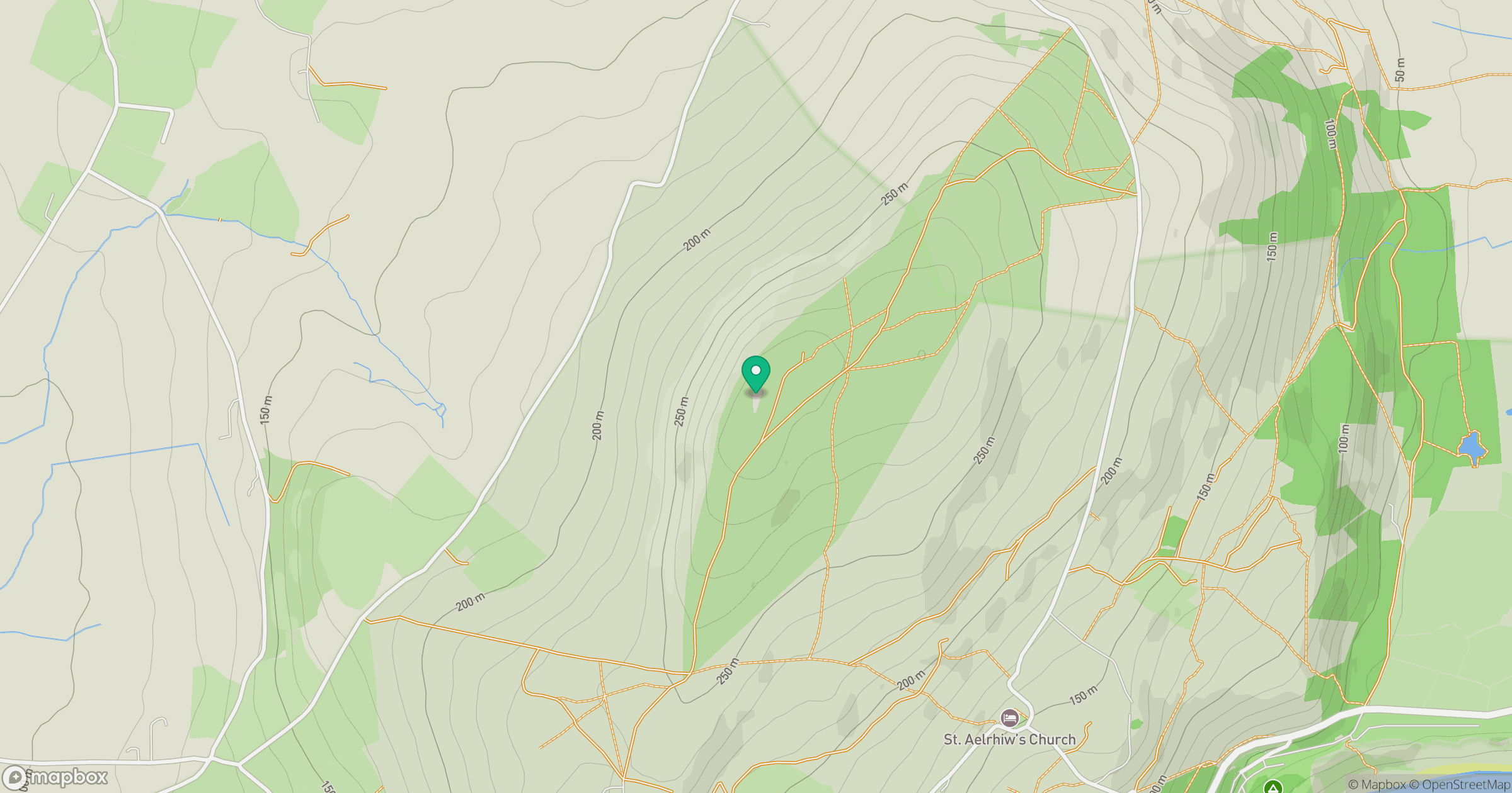
Grid reference: SH228293
View on OpenStreetMapOpens a map in a new tab, centred on the hill.
No comments yet. Be the first.