

Carn Fadryn
Good walks are even better shared.
SH2735 : Olion Oes Haearn / Iron Age remains
Ceri Thomas Photo source
Overview
Carn Fadryn is a 371 m Marilyn in the heart of the Llŷn Peninsula, above Garnfadryn village in Gwynedd. A short, steep path reaches its rocky summit and extensive hillfort remains. A longer circuit also visits neighbouring Garn Bach, with broad views across the peninsula and coast.
Carn Fadryn
Introduction
Carn Fadryn is a 371 m Marilyn on the Llŷn Peninsula in Gwynedd, overlooking Garnfadryn village. Its rocky summit, hillfort and broad coastal views make a compact hillwalk; the neighbouring Garn Bach can be included in a longer circuit.
Summit and terrain
The natural high point is a rock 2 m southeast of the trig pillar. DoBIH records its top as 10 cm above the pillar’s flush bracket. The ancient walls and summit stronghold are separate archaeological features. The approach climbs from an enclosed lane onto grassy and stony paths, with steep rocky steps near the top. The longer route crosses fields and stiles.
Walking routes
Carn Fadryn from Garnfadryn
From the roadside parking west of Garnfadryn’s former chapel (SH278345), walk back past the chapel and turn left up the enclosed lane. Beyond the gate, turn right with the wall on your right. The path later turns left away from the wall and climbs steeply to the summit area. Return by the same path and lane to the parking. Walking Britain gives 2.4 km, 182 m of ascent and 1 hour 20 minutes for the full return, graded easy; the upper path is steep and rocky.
Garn Bach and Carn Fadryn circuit
Start west of the former chapel in Garnfadryn (SH278345). Follow the lane with Carn Fadryn on your right, continuing straight at the first junction and taking the right branch at the next two forks. Tracks and field paths pass the plantation, then lead east and southeast to Caerau-Uchaf. Continue towards Pen-y-Caeru; before its trees, turn right by the wall and climb Garn Bach. Descend beside the wall to the col, pass through the wall gap and follow the grassy path southwest, then turn uphill through another gap for Carn Fadryn. Retrace the summit path to the lower wall, bear right, and take the enclosed track on the left back to the village and parking. Walking Britain gives 8.1 km, 333 m of ascent and 3 hours 20 minutes for this complete two-hill circuit, graded easy to moderate. Expect overgrown paths, gates, stiles and a steep summit climb.
Views
The summit overlooks the Llŷn Peninsula and its surrounding coast. Eryri lies to the northeast, while Garn Bach is southeast of the main summit. Long-distance views depend on visibility.
Geology
Carn Fadryn is formed by a porphyritic quartz-microdiorite intrusion of Caradoc age within the Ordovician. British Geological Survey descriptions identify quartz and plagioclase crystals in a finer-grained groundmass. Nearby Garn Bach is formed by a separate dacite intrusion.
History
The scheduled hillfort, CN011, has two phases of stone defences and numerous hut remains. A small summit stronghold is commonly identified with the castle of the sons of Owain Gwynedd described by Gerald of Wales in 1188; Cadw and Heneb qualify that identification. The scheduled area also includes settlement remains on Garn Bach.
Access and facilities
Both described walks start at SH278345 beside Garnfadryn’s former chapel. Parking is limited and the lane and entrances must remain clear. Nefyn Coaches 8A and some Saturday 8B journeys appear in the village timetables, but check both directions and school-day conditions before relying on them. Bring food and drinking water for the walk.
Published routes describe the hill’s access land and village approach. Check Gwynedd rights-of-way information and Natural Resources Wales access restrictions before travel, and follow notices on the ground.
Safety and heritage care
The upper path is steep and can be slippery when wet. The summit is exposed to wind and low cloud; allow daylight for the descent. The longer circuit includes overgrown field paths, gates, stiles and lanes. Keep dogs under close control near livestock, use existing paths and wall gaps, and leave the ancient masonry undisturbed.
Maps and sources
OS Explorer 253 and Landranger 123 cover the hill. Sources checked on 17 October 2026; this is separate from the DoBIH row revision of 6 December 2020, BGS memoir publication in 2002, and Cadw’s historical May 2011 site audit. The published walking times apply to complete returns; cycling itineraries and one-way ascent times are not used.
Explore routes near Carn Fadryn
Walks starting near this hill. Open a route to check its map, distance and full itinerary.
Yr Eifl and the Gyrns guided mountain walk
View route
Beddgelert Forest: Llyn Llywelyn Woodland Circuit
View route
Beddgelert Forest: Derwen Circuit and Llyn Llywelyn
View route
Northern Rhinogydd guided mountain walk
View route
Route planning notes
These notes describe possible approaches. Check a route's map and access information when planning your walk.
Carn Fadryn from Garnfadryn
From the roadside parking west of Garnfadryn’s former chapel (SH278345), walk back past the chapel and turn left up the enclosed lane. Beyond the gate, turn right with the wall on your right. The path later turns left away from the wall and climbs steeply to the summit area. Return by the same path and lane to the parking. Walking Britain gives 2.4 km, 182 m of ascent and 1 hour 20 minutes for the full return, graded easy; the upper path is steep and rocky.
Garn Bach and Carn Fadryn circuit
Start west of the former chapel in Garnfadryn (SH278345). Follow the lane with Carn Fadryn on your right, continuing straight at the first junction and taking the right branch at the next two forks. Tracks and field paths pass the plantation, then lead east and southeast to Caerau-Uchaf. Continue towards Pen-y-Caeru; before its trees, turn right by the wall and climb Garn Bach. Descend beside the wall to the col, pass through the wall gap and follow the grassy path southwest, then turn uphill through another gap for Carn Fadryn. Retrace the summit path to the lower wall, bear right, and take the enclosed track on the left back to the village and parking. Walking Britain gives 8.1 km, 333 m of ascent and 3 hours 20 minutes for this complete two-hill circuit, graded easy to moderate. Expect overgrown paths, gates, stiles and a steep summit climb.
Make a day of it, together
Find someone to share the walk with, or organise a day out along a route you like.
Photo Gallery
View all Photo could not load
SH2735 : Olion Oes Haearn / Iron Age remains
Ceri Thomas
 Photo could not load
SH2735 : Rocky summit
Jonathan Wilkins
 Photo could not load
SH2735 : Carnfadryn, Lleyn Peninsula
Nia Thomas
 Photo could not load
SH2735 : Brigau creigiog ar Garn Fadryn / Rocky outcrops on Garn Fadryn
Ceri Thomas
 Photo could not load
SH2735 : Marian a sbriws / Scree and spruce
Ceri Thomas
 Photo could not load
SH2735 : Hut Circles, Carn Fadryn
Chris Andrews
 Photo could not load
SH2735 : Olion Oes Haearn / Iron Age remains (2)
Ceri Thomas
 Photo could not load
SH2735 : Hut circles
Dewi
 Photo could not load
SH2735 : View of Carn Fadryn
Oliver Dixon

SH2735 : Bryngaer Carn Fadrun / Caer Fadrun Hillfort
Alan Richards
Hill facts and local notes
Classifications
Elevation
371m
1,217 ft
Prominence
343m
Coordinates
52.8865, -4.5599
SH278351
OS Map
123
Explorer: 253
At the Summit
The DoBIH high point is a rock 2 m southeast of the trig pillar. The top of this rock is recorded as 10 cm above the pillar’s flush bracket. The hillfort walls and summit stronghold are separate archaeological features.
Terrain & Geology
Carn Fadryn is formed by a porphyritic quartz-microdiorite intrusion of Caradoc age within the Ordovician. British Geological Survey descriptions identify quartz and plagioclase crystals in a finer-grained groundmass. Nearby Garn Bach is formed by a separate dacite intrusion.
Views & Scenery
Broad views across the Llŷn Peninsula and surrounding coast, with the mountains of Eryri to the northeast in clear weather. Garn Bach lies southeast of the main summit.
History & Heritage
Historical Significance
The scheduled hillfort, CN011, has two phases of stone defences and numerous hut remains. A small summit stronghold is commonly identified with the castle of the sons of Owain Gwynedd described by Gerald of Wales in 1188; Cadw and Heneb qualify that identification. The scheduled area also includes settlement remains on Garn Bach.
Getting There & Facilities
Parking
Roadside parking just west of the former chapel in Garnfadryn, SH278345, is the start used by both published routes. Space is limited; keep entrances and the narrow lane clear. Check Gwynedd rights-of-way information, NRW access restrictions and local notices before walking.
Public Transport
Garnfadryn appears in Nefyn Coaches 8A timetables and on some Saturday 8B journeys. Service is sparse and varies by direction and school-day conditions. Check the current Gwynedd or Traveline timetable for both legs before planning a bus-based walk.
Nearby Facilities
Bring food and drinking water for the walk.
Safety Information
Known Hazards
- The summit approach is steep and rocky, with steps; wet rock and grass can be slippery on descent.
- The hilltop is exposed to strong winds and low cloud. Leave enough daylight to descend the rocky path.
- The longer circuit includes lanes, stiles and overgrown field paths. Follow established paths and wall gaps, protect the hillfort remains, and keep dogs under close control around livestock.
General Safety Tips
- Check weather conditions before setting out
- Carry appropriate clothing and equipment
- Let someone know your planned route
- Take a map, compass, and GPS device
- Carry emergency supplies: food, water, first aid kit, torch
Hills
Some common questions about the hills answered
Are there group walks up Carn Fadryn?
Many walkers use Walkmates to join or organise walks with others. You can check for group walks around Carn Fadryn through the maps
Are there other walkers around Carn Fadryn?
Activity varies by location and time, but Walkmates lets you see whether others have shared walks or shown interest in this area. Find other people through the walking friends search walking friends for Carn Fadryn search or of course create your own walk for Carn Fadryn
Can I organise a walk to Carn Fadryn?
Yes. If there aren’t any walks listed already, you can create a walk and make it available for others to join.
If you're signed up to Walkmates, you can create a walk to Carn Fadryn.
How do I find a walk up this hill?
There are often multiple ways to walk this hill, depending on experience and route preference. Walkmates helps you explore walks and routes that others have shared.
Can I suggest a new route up Carn Fadryn?
Yes. You can suggest or create routes to share with others. Walkmates focuses on the social side of walking, so routes are used to help people organise walks and explore areas together, rather than as detailed navigation tools or route libraries.
Other uses really appreciate knowledgeable walkers sharing their routes. Share your favourite route to Carn Fadryn here
The is an error or something incorrect about this hill. How do I let you know?
We always strive to keep the information on Walkmates as accurate as possible. If you find an error, please let us know through the contact form and we'll aim to correct it as quickly as possible
Community Discussion
Comments
Location
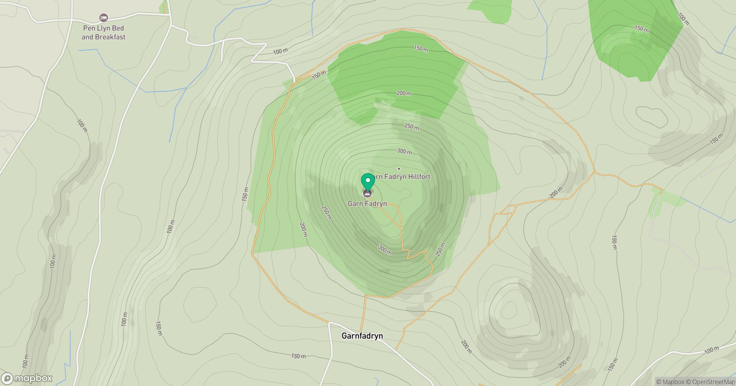
Grid reference: SH278351
View on OpenStreetMapOpens a map in a new tab, centred on the hill.
No comments yet. Be the first.