

Mynydd Cennin
Good walks are even better shared.
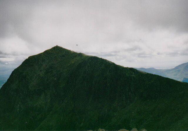
SH4545 : View towards the summit of Mynydd Cennin
Eric Jones Photo source
Overview
Mynydd Cennin
Mynydd Cennin, standing proud at 307 meters, may not be the highest hill in Snowdonia National Park, but what it lacks in height, it certainly makes up for in charm and scenery. Let’s dive into what makes this lesser-known gem a worthy addition to your hiking log.
Geology
As you trek up Mynydd Cennin, take a moment to appreciate the Ordovician slate and mudstone that make up this ancient mountain. Created during a time when the earth was still a bit rough around the edges, the rock formations tell a tale of geological turmoil.
Routes
Garn Fadryn to Mynydd Cennin
This moderate trek begins at Garn Fadryn and leads you through picturesque pastures, with the scent of wildflowers filling the air. The route is approximately 5 km long and can be tackled in about 2.5 hours. A perfect way to shake off the cobwebs!
Summit Features
At the summit, you'll find a stone cairn — a perfect spot for the obligatory summit photo. Don’t forget to give it a little pat; it’s a great listener!
Terrain Type
Expect a delightful mix of grassy patches and rocky outcrops. It’s not too strenuous, but do watch your step. We wouldn’t want you to end up doing the mountain's equivalent of a backflip!
Views
Highlights
Once you reach the top, prepare to have your breath taken away! The views span the Llyn Peninsula, with a chance to glimpse Snowdonia's towering peaks and even the Isle of Anglesey if visibility is kind.
Best Seasons
The best times to catch these views are during spring and early autumn when the skies are clearer and the landscape bursts with colours. A real treat for the eyes!
Hazards
Keep an eye on the weather! The infamous Welsh mist can roll in faster than you can say 'Boo!', turning your trail from scenic to slippery without warning. Stick to the paths and enjoy your hike without any unwanted tumbles.
Nearby Summits
If you’re feeling adventurous, nearby Garn Fadryn and Mynydd Anelog await to challenge your sense of exploration. Both offer their unique views and stunning landscapes!
Access
Getting to Mynydd Cennin is straightforward. The nearest parking is at a layby off the A497, about 2 km from the trailhead. While there is some public transport available from Pwllheli, a car is recommended for easy access.
Facilities
While Mynydd Cennin is blissfully isolated, nearby Pwllheli provides all the necessary comforts with cafes, restaurants, and public toilets. So, indulge in a post-hike treat!
History
Name Meaning
The name 'Mynydd Cennin' translates to 'mountain of the onion' — a quirky title, reflecting perhaps the local love for agriculture and produce.
Significance
Historically, Mynydd Cennin holds its place within the fabric of local folklore and tradition, making it a part of the community's identity.
In conclusion, whether you’re looking for a peaceful escape or a rewarding hike, Mynydd Cennin offers delightful scenery and a taste of Welsh cultural heritage. Happy hiking!
Explore routes near Mynydd Cennin
Walks starting near this hill. Open a route to check its map, distance and full itinerary.
Yr Eifl and the Gyrns guided mountain walk
View route
Beddgelert Forest: Llyn Llywelyn Woodland Circuit
View route
Beddgelert Forest: Derwen Circuit and Llyn Llywelyn
View route
Snowdon Pyg Track returning by Miner's Track
View route
Route planning notes
These notes describe possible approaches. Check a route's map and access information when planning your walk.
Garn Fadryn to Mynydd Cennin
A scenic route that begins at Garn Fadryn and leads you through lush valleys and bracken-covered hillsides before ascending towards the summit.
Make a day of it, together
Find someone to share the walk with, or organise a day out along a route you like.
Photo Gallery
View all Photo could not load
SH4545 : View towards the summit of Mynydd Cennin
Eric Jones
 Photo could not load
SH4544 : Mynydd Cennin
Rude Health
Hill facts and local notes
Classifications
Elevation
262m
860 ft
Prominence
105m
Coordinates
52.9798, -4.2976
SH458449
OS Map
123
Explorer: 254
At the Summit
The summit of Mynydd Cennin boasts an impressive stone cairn, perfect for a summit selfie. On a clear day, you might also find a trig point, surveying the land like a well-preserved sentinel.
Terrain & Geology
Mynydd Cennin is primarily composed of Ordovician slate and mudstone, contributing to its characteristic rugged appearance. The slate was formed during a period of intense geological activity, showcasing some fascinating folding and faulting.
Views & Scenery
From the summit, you'll be treated to sweeping views of the Llyn Peninsula, Snowdonia's majestic peaks, and, if you're lucky, a glimpse of the Isle of Anglesey on the horizon.
History & Heritage
Name Origin
The name 'Mynydd Cennin' translates to 'mountain of the onion' in Welsh, possibly reflecting the agricultural practices in the area.
Historical Significance
The mountain holds local significance, often linked to folklore and traditional farming practices in the vicinity.
Getting There & Facilities
Parking
Parking is available at the small layby off the A497, approximately 2 km from the trailhead.
Public Transport
Buses run from Pwllheli to nearby villages, but a car is recommended for easier access.
Nearby Facilities
There are no facilities on the mountain itself, but Pwllheli offers cafes, restaurants, and public toilets to cater to your needs before or after your hike.
Safety Information
Known Hazards
- Misty conditions can reduce visibility, and rocky terrain may become slippery when wet. As always, keep an eye on the weather and be mindful of where you tread!
General Safety Tips
- Check weather conditions before setting out
- Carry appropriate clothing and equipment
- Let someone know your planned route
- Take a map, compass, and GPS device
- Carry emergency supplies: food, water, first aid kit, torch
Hills
Some common questions about the hills answered
Are there group walks up Mynydd Cennin?
Many walkers use Walkmates to join or organise walks with others. You can check for group walks around Mynydd Cennin through the maps
Are there other walkers around Mynydd Cennin?
Activity varies by location and time, but Walkmates lets you see whether others have shared walks or shown interest in this area. Find other people through the walking friends search walking friends for Mynydd Cennin search or of course create your own walk for Mynydd Cennin
Can I organise a walk to Mynydd Cennin?
Yes. If there aren’t any walks listed already, you can create a walk and make it available for others to join.
If you're signed up to Walkmates, you can create a walk to Mynydd Cennin.
How do I find a walk up this hill?
There are often multiple ways to walk this hill, depending on experience and route preference. Walkmates helps you explore walks and routes that others have shared.
Can I suggest a new route up Mynydd Cennin?
Yes. You can suggest or create routes to share with others. Walkmates focuses on the social side of walking, so routes are used to help people organise walks and explore areas together, rather than as detailed navigation tools or route libraries.
Other uses really appreciate knowledgeable walkers sharing their routes. Share your favourite route to Mynydd Cennin here
The is an error or something incorrect about this hill. How do I let you know?
We always strive to keep the information on Walkmates as accurate as possible. If you find an error, please let us know through the contact form and we'll aim to correct it as quickly as possible
Community Discussion
Comments
Location
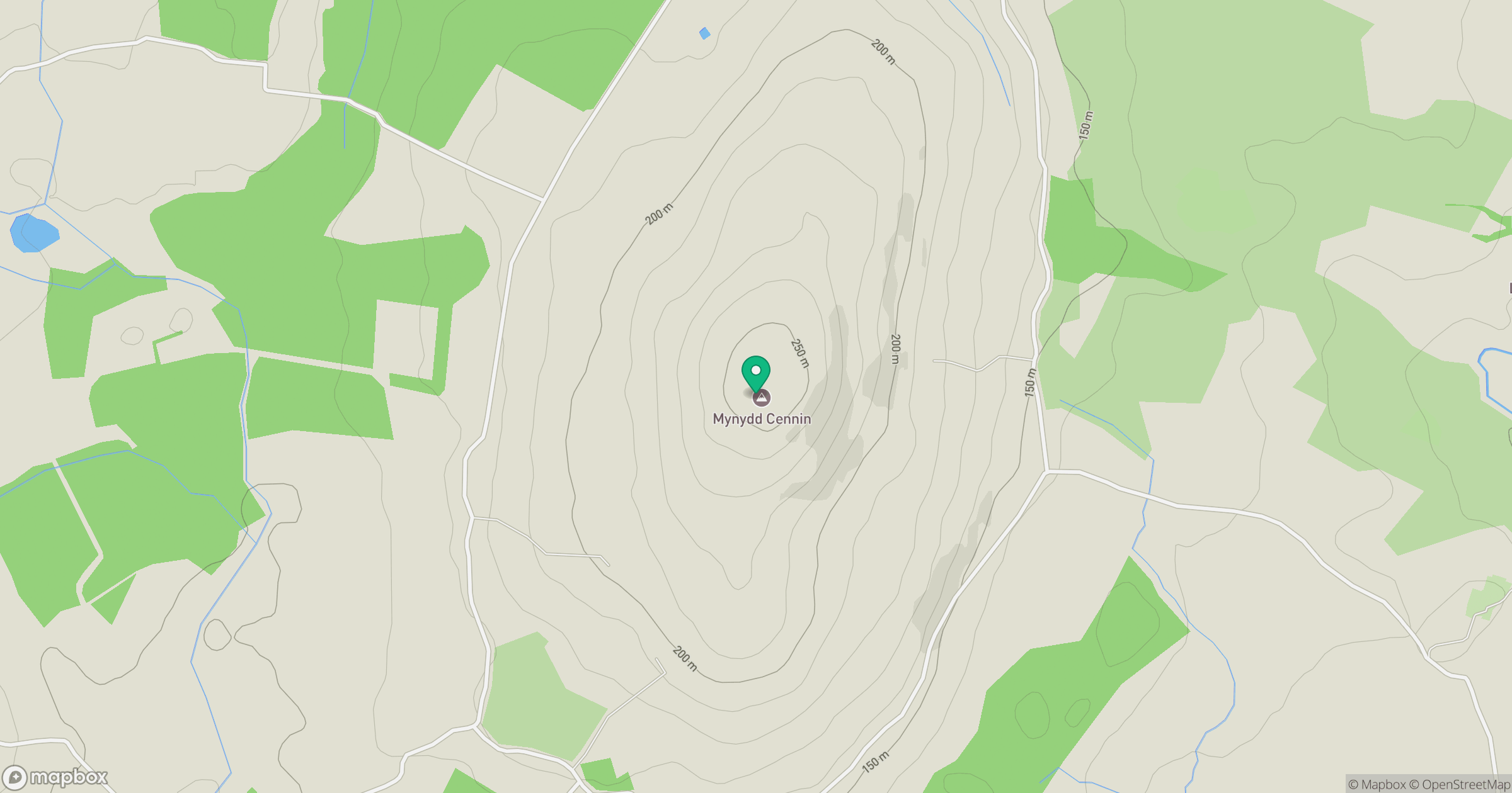
Grid reference: SH458449
View on OpenStreetMapOpens a map in a new tab, centred on the hill.
No comments yet. Be the first.