

Meluncart
Good walks are even better shared.
Overview
Meluncart: The Hidden Gem of the Lake District
Nestled gracefully in the Lake District, Meluncart may not be the highest mountain in the range, but it surely holds its own, offering a captivating experience for hikers and outdoor adventurers alike.
Geology
Meluncart boasts a striking composition of slate, characteristic of the era it formed in— the Ordovician period. This gives the mountain a distinct rugged quality, making it not just a sight to behold, but a fascinating subject for geology enthusiasts.
Access
Getting to Meluncart is a breezy affair. The nearest town, Ambleside, is well-connected by public transport, with regular buses ensuring that you won’t have to hitchhike your way to adventure. Plenty of parking is available in Ambleside, so you can leave your car and start your trek without a hitch!
The Route
The Meluncart Circuit is a popular choice amongst locals and visitors alike, clocking in at approximately 12.5 km. This moderate route offers those willing to tackle it stunning views all around, showcasing everything from shimmering lakes to majestic peaks.
Terrain and Summit Features
The mountain's terrain is an exciting mix of rocky and grassy paths, with the occasional boggy patch—so grip those boots tight! Upon reaching the summit, you'll be greeted by a lovely cairn that stands as a proud testament to fellow adventurers who have made the trek.
Views
Once at the top, prepare to be awed! The views from Meluncart are nothing short of breathtaking. You'll have an uninterrupted sightline towards Coniston Water and the rugged charm of the Langdale Pikes, making every step worth it. Aim for late spring or early autumn for the best sights and colours.
Hazards
As with any adventure in the mountains, it's wise to keep an eye on the weather. The Lake District is notorious for its unpredictability—sunshine one moment, and snow the next! Prepare accordingly to ensure a fun and safe expedition.
Nearby Summits
For those keen on a bit more hiking, nearby peaks such as Seat Sandal and Fairfield reward unwavering spirits with even higher views and challenges.
Facilities
Once you've conquered Meluncart, reward yourself in Ambleside with a slice of cake and a toilet stop. Equal parts rustic and charming, this little town is sure to hit the spot after a long day outdoors.
Conclusion
In summary, Meluncart is a delightful destination that offers wonderful experiences for any outdoor enthusiast. Whether you're a seasoned climber or simply seeking a scenic day out, Meluncart will certainly make your hiking boots happy.
Now, go forth and conquer this hidden gem of the Lake District!
Explore routes near Meluncart
Public walks starting within 80 km of this hill. Nearby does not mean a route reaches the summit; check its map and access before setting out.
Banchory to Milton of Crathes: Deeside Way return
View route
Potarch to Shooting Greens: Deeside Way return
View route
Milton of Crathes to Drumoak: Deeside Way return
View route
Loch Kinord: Muir of Dinnet Woodland Circuit
View route
Route planning notes
These notes describe possible approaches, not verified navigable routes or permission to cross land. Check current paths, local access rules and conditions before setting out.
Meluncart Circuit
A circular route starting from the village of Ambleside, taking in Meluncart and providing some delightful views of the surrounding landscape.
Make a day of it, together
Find someone to share the walk with, or organise a day out along a route you like.
Photo Gallery
View all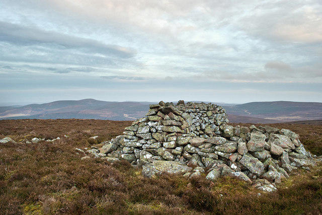 Photo could not load
NO6382 : Shelter on Meluncart
Nigel Corby
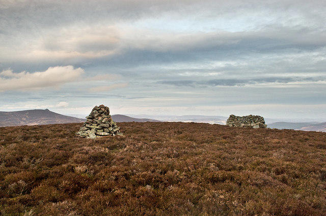 Photo could not load
NO6382 : Cairn and shelter on Meluncart
Nigel Corby
Hill facts and local notes
Classifications
Elevation
525m
1,722 ft
Prominence
106m
Coordinates
56.9280, -2.6088
NO630820
OS Map
45
Explorer: 396
At the Summit
The summit is marked by a modest but sturdy cairn—perfect for photo ops and for leaving your trail mix behind if you're feeling a bit quirky.
Terrain & Geology
Meluncart is primarily composed of Slate, a common geological feature in the Lake District that formed during the Ordovician period. This geological history gives the mountain its characteristic ruggedness and charm.
Views & Scenery
From the summit, you'll enjoy panoramic views of the nearby Coniston Water and the rugged peaks of the Langdale Pikes in the distance.
History & Heritage
Name Origin
The name 'Meluncart' is believed to derive from the Old Norse 'Mellungar,' referring to the surrounding hills and valleys.
Historical Significance
Local folklore suggests that the area was a meeting point for travellers in the past, making it a place rich with stories waiting to be told.
Getting There & Facilities
Check current local access restrictions, parking rules and transport timetables before travelling. These notes do not confirm public access to the summit.
Parking
There is ample parking available in Ambleside, with car parks typically charging a small fee. Aim for the main car park on Lake Road for easy access.
Public Transport
Ambleside is accessible via the Stagecoach bus services, which connect to larger towns like Windermere and Kendal.
Nearby Facilities
Cafes and toilets can be found in Ambleside, where you can refuel with a scone or two before your adventure.
Safety Information
Known Hazards
- Be cautious of sudden weather changes; it’s not uncommon for sun and snow to share a friendly handshake on Meluncart.
General Safety Tips
- Check weather conditions before setting out
- Carry appropriate clothing and equipment
- Let someone know your planned route
- Take a map, compass, and GPS device
- Carry emergency supplies: food, water, first aid kit, torch
Hills
Some common questions about the hills answered
Are there group walks up Meluncart?
Many walkers use Walkmates to join or organise walks with others. You can check for group walks around Meluncart through the maps
Are there other walkers around Meluncart?
Activity varies by location and time, but Walkmates lets you see whether others have shared walks or shown interest in this area. Find other people through the walking friends search walking friends for Meluncart search or of course create your own walk for Meluncart
Can I organise a walk to Meluncart?
Yes. If there aren’t any walks listed already, you can create a walk and make it available for others to join.
If you're signed up to Walkmates, you can create a walk to Meluncart.
How do I find a walk up this hill?
There are often multiple ways to walk this hill, depending on experience and route preference. Walkmates helps you explore walks and routes that others have shared.
Can I suggest a new route up Meluncart?
Yes. You can suggest or create routes to share with others. Walkmates focuses on the social side of walking, so routes are used to help people organise walks and explore areas together, rather than as detailed navigation tools or route libraries.
Other uses really appreciate knowledgeable walkers sharing their routes. Share your favourite route to Meluncart here
The is an error or something incorrect about this hill. How do I let you know?
We always strive to keep the information on Walkmates as accurate as possible. If you find an error, please let us know through the contact form and we'll aim to correct it as quickly as possible
Community Discussion
Comments
Location
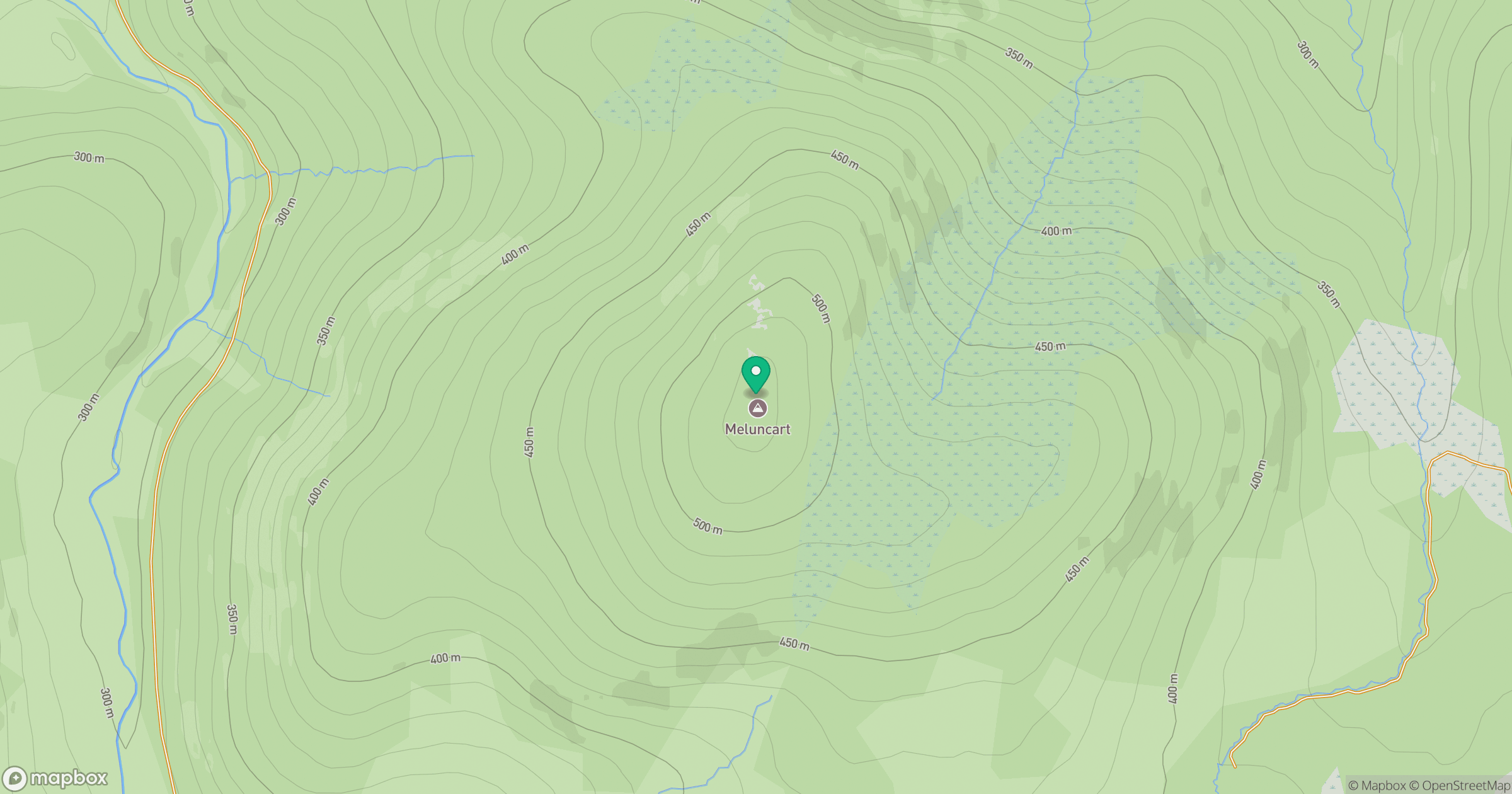
Grid reference: NO630820
View on OpenStreetMapOpens a map in a new tab, centred on the hill.
Hills within 30 km
Straight-line distance, not a walking route or confirmation of access.
No comments yet. Be the first.