

Meall Fuar-mhonaidh
Good walks are even better shared.
NH4522 : Meall Fuar-mhonaidh summit cairn
Ian Stewart Photo source
Overview
Meall Fuar-mhonaidh
Overview
Meall Fuar-mhonaidh, standing proud at 665 meters, is a gem of the Scottish Highlands. Known for its stunning vistas and delightful trails, it's a favourite amongst hikers. The mountain, with its impressive prominence and well-defined summit, is a Munro that entices both seasoned adventurers and those who are just looking for a scenic 'stroll'.
Geology
This mountain tells a tale of time with its ancient metamorphic rocks, mostly from the Moine Supergroup. Their durability lends the hill a noble robust quality, making it a sought-after destination for both geology enthusiasts and casual walkers.
Routes
The Southern Approach from Glen Geshie is the most popular. This moderate hike allows you to ascend steadily, appreciating the landscape around you as you climb. Clocking in at about 8.5 km, you can expect to spend approximately 3.5 hours getting to the top, assuming you don’t stop too much to fuss over the local sheep.
Summit Features
Upon reaching the summit, hikers will be greeted by a rocky outcrop and an inviting cairn – a perfect spot to take a breather and capture a photo. With the Highland air around you, it’s the ideal setting to ponder life’s great mysteries or perhaps just the location of the nearest pub.
Terrain
The terrain varies considerably: grassy slopes entice you upwards, while rocky outcrops challenge your footing. And yes, you may encounter a bit of heather that seems determined to play games with your ankles.
Views
The panoramic views from the top are nothing short of breathtaking. To the east, the majestic Cairngorms stretch out, while Glen Geshie lies serenely below. Take this moment to revel in your achievement, and maybe even indulge in a little daydream about making it onto a Scottish postcard.
Hazards
As with many Scottish hills, the unpredictable weather is your greatest foe. Therefore, be prepared for sudden changes—it can go from sunny to 'where did that cloud come from?' in a heartbeat.
Access
Parking
You’ll find ample parking at the Glen Geshie car park, just off the A9. Arrive early, or risk playing a game of musical chairs with your parking space.
Public Transport
Buses from Aviemore will whisk you away to the nearest town, but be prepared for a bit of footwork post-drop-off.
Nearest Town
The charming village of Newtonmore serves as an excellent starting point for your adventure, replete with small shops for anything you might need—cake, perhaps?
Facilities
Cafes and shops are the order of the day in Newtonmore, along with the odd public toilet, just in case you were wondering!
History
The name ‘Meall Fuar-mhonaidh’ hints at its boggy origins, but don’t let that put you off! It's a beloved Munro cherished by many that have ascended its slopes across generations—each adding their own stories to its rich tapestry.
Whether you’re a novice or an experienced hillwalker, a day on Meall Fuar-mhonaidh promises to be a rewarding adventure amidst the beauty of the Scottish Highlands. Pack your bags, put on your hiking boots, and let the journey begin!
Explore routes near Meall Fuar-mhonaidh
Walks starting near this hill. Open a route to check its map, distance and full itinerary.
Fort Augustus to Kytra Lock: Caledonian Canal Towpath
View route
Glen Affric: Coire Loch Woodland Trail
View route
Aviemore: Loch an Eilein and the Croft Track from Rothiemurchus
View route
Rothiemurchus: Beaver Trail and Lochan Mor
View route
Route planning notes
These notes describe possible approaches. Check a route's map and access information when planning your walk.
Southern Approach from Glen Geshie
A well-trodden path leading from the glen that offers a steady ascent to the summit, with splendid views of the surrounding hills.
Make a day of it, together
Find someone to share the walk with, or organise a day out along a route you like.
Photo Gallery
View all Photo could not load
NH4522 : Meall Fuar-mhonaidh summit cairn
Ian Stewart
 Photo could not load
NH4522 : Meall Fuar-mhonaidh
Anne Burgess
 Photo could not load
NH4522 : Meall Fuar-mhonaidh
John Hedger
 Photo could not load
NH4522 : Cairn on Meall Fuar-mhonaidh
Steven Brown
 Photo could not load
NH4522 : Summit cairn, Meall Fuar-mhonaidh.
Chris Eilbeck
 Photo could not load
NH4522 : Meall Fuar-mhonaidh from Foyers
Bill McWhirter
 Photo could not load
NH4522 : Summit cairn of Meall Fuar-mhonaidh
David Maclennan
 Photo could not load
NH4522 : Summit cairn of Meall Fuar-mhonaidh
David Maclennan
 Photo could not load
NH4522 : Summit, Meall Fuar-mhonaidh
Richard Webb

NH4522 : Summit, Meall Fuar-mhonaidh
Richard Webb
Hill facts and local notes
Classifications
Elevation
698m
2,291 ft
Prominence
233m
Coordinates
57.2645, -4.5600
NH457222
OS Map
26
Explorer: 416S
At the Summit
The summit features a distinctive rocky outcrop and a small cairn, perfect for a photo op. On a clear day, you might even spot a few locals engaging in their favourite pastime: pretending to know the names of all the other Munros in view.
Terrain & Geology
Meall Fuar-mhonaidh is predominantly composed of ancient metamorphic rocks, mainly of the Moine Supergroup. This geological formation is renowned for its resilience against erosion, providing the mountain with its rugged yet charming landscape.
Views & Scenery
From the summit, one can see a breathtaking panorama of the Cairngorms to the east and a fine view over Glen Geshie. If you squint hard enough, you might even catch a glimpse of the Loch Ness Monster, but I wouldn’t bet on it.
History & Heritage
Name Origin
The name 'Meall Fuar-mhonaidh' translates to 'The cold hill of the bog', which might make you second-guess your decision, but the views are worth it.
Historical Significance
As a Munro, it holds a special place in the hearts of Scottish hillwalkers and is often conquered as part of a larger walking adventure in the scenic Highlands.
Getting There & Facilities
Parking
There are parking facilities available at the Glen Geshie car park, located just off the A9, suitable for a good number of vehicles before the 'space' runs out.
Public Transport
The nearest bus service is from Aviemore, although it may require a bit of a walk after your ride drops you off.
Nearby Facilities
Newtonmore has a few cafes and local shops, and if you're lucky, you might even find a public toilet for those crucial moments before your climb.
Safety Information
Known Hazards
- Be mindful of sudden weather changes, especially the infamous Highland mists that can roll in unexpectedly. Also, watch your step on rocky paths and keep an eye out for soggy patches that could turn into mini lakes in rainy seasons.
General Safety Tips
- Check weather conditions before setting out
- Carry appropriate clothing and equipment
- Let someone know your planned route
- Take a map, compass, and GPS device
- Carry emergency supplies: food, water, first aid kit, torch
Hills
Some common questions about the hills answered
Are there group walks up Meall Fuar-mhonaidh?
Many walkers use Walkmates to join or organise walks with others. You can check for group walks around Meall Fuar-mhonaidh through the maps
Are there other walkers around Meall Fuar-mhonaidh?
Activity varies by location and time, but Walkmates lets you see whether others have shared walks or shown interest in this area. Find other people through the walking friends search walking friends for Meall Fuar-mhonaidh search or of course create your own walk for Meall Fuar-mhonaidh
Can I organise a walk to Meall Fuar-mhonaidh?
Yes. If there aren’t any walks listed already, you can create a walk and make it available for others to join.
If you're signed up to Walkmates, you can create a walk to Meall Fuar-mhonaidh.
How do I find a walk up this hill?
There are often multiple ways to walk this hill, depending on experience and route preference. Walkmates helps you explore walks and routes that others have shared.
Can I suggest a new route up Meall Fuar-mhonaidh?
Yes. You can suggest or create routes to share with others. Walkmates focuses on the social side of walking, so routes are used to help people organise walks and explore areas together, rather than as detailed navigation tools or route libraries.
Other uses really appreciate knowledgeable walkers sharing their routes. Share your favourite route to Meall Fuar-mhonaidh here
The is an error or something incorrect about this hill. How do I let you know?
We always strive to keep the information on Walkmates as accurate as possible. If you find an error, please let us know through the contact form and we'll aim to correct it as quickly as possible
Community Discussion
Comments
Location
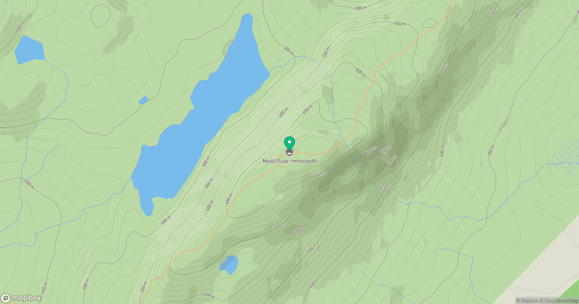
Grid reference: NH457222
View on OpenStreetMapOpens a map in a new tab, centred on the hill.
Nearby Hills
Beinn Mheadhoin
541m
Cul Mor
393m
Creag Meagaidh
1,128m
Sgurr a' Choire Ghlais
1,084m
Binnein Mor
550m
No comments yet. Be the first.