
Creag nan Eun
Good walks are even better shared.
Overview
Creag nan Eun
Welcome to Creag nan Eun, a gem nestled in the stunning Scottish Highlands. At an elevation of 689 meters, this Corbett is a favourite among hikers looking to immerse themselves in Scotland's breathtaking landscapes.
Geology
Creag nan Eun boasts ancient sedimentary rocks that tell stories of a bygone era shaped by relentless glaciers. As you ascend, keep an eye out for interesting rock formations that may just spark your inner geologist.
Routes
One of the most popular routes begins at Glen Moriston. This 10 km adventure takes approximately 4 hours, with a moderate level of difficulty, making it suitable for those with some level of hiking experience. Starting amidst lush forestry, the trail leads to grassy slopes that seem to beckon you to the summit. But beware the rocky outcrops; they have a tendency to trip up careless footers!
Summit Features
At the summit, you'll find a large stone cairn that stands proud as a testament to your ascent. It's the perfect spot for a quick selfie or for simply soaking in the panoramic views of the Highlands that lay out before you like a well-done Scottish tapestry!
Views
From the summit, you'll be treated to stunning vistas including the famous Loch Ness and the remote peaks of Glenshiel. The best seasons for enjoying this natural beauty are spring and autumn, when the air is crisp and the colours are simply magnificent.
Hazards
As with any mountain adventure, be cautious of the uneven terrain and the capricious Scottish weather. A sunny morning can easily turn into a foggy afternoon, and we wouldn't want your hike to end in a game of hide-and-seek with the clouds!
Nearby Summits
If you're looking for additional hiking challenges nearby, be sure to check out Sgurr na Sguabaich and Sgurr an Doire Leathain. These neighbouring peaks are just as stunning and will add some variety to your expedition.
Access
The nearest parking is conveniently located at the Glen Moriston trailhead, where you'll find enough space for several cars, ensuring you won’t have to play the ‘find a parking spot’ game. If you're relying on public transport, be advised that options are a bit limited; however, you can hop on a bus from Inverness to reach nearby villages. The closest town, Invermoriston, is a mere 6 km away, and you'll find basic facilities like a small shop and public toilets there to cushion your adventure.
History
The name 'Creag nan Eun' translates to 'rock of the bird', a nod to the area’s rich birdwatching opportunities. This mountain has been a staple in the hiking community for ages, well-loved for both its exhilarating views and easy access.
So, lace up your boots and prepare for an adventure — Creag nan Eun awaits your exploration!
Explore routes near Creag nan Eun
Public walks starting within 80 km of this hill. Nearby does not mean a route reaches the summit; check its map and access before setting out.
Great Glen Way low route: Fort Augustus to Invermoriston Old Bridge
View route
Fort Augustus to Kytra Lock: Caledonian Canal Towpath
View route
Glen Affric: Coire Loch Woodland Trail
View route
Loch Affric full circuit from River Affric
View route
Route planning notes
These notes describe possible approaches, not verified navigable routes or permission to cross land. Check current paths, local access rules and conditions before setting out.
From Glen Moriston
A scenic ascent starting from Glen Moriston, weaving through lush forests before tackling the grassy slopes towards the summit.
Make a day of it, together
Find someone to share the walk with, or organise a day out along a route you like.
Hill facts and local notes
Classifications
Elevation
418m
1,371 ft
Prominence
115m
Coordinates
57.2228, -4.5895
NH437176
OS Map
34
Explorer: 416S
At the Summit
The summit is marked with a large stone cairn, perfect for a photo-op, and offers a panoramic view of the surrounding highlands.
Terrain & Geology
The mountain is primarily composed of ancient sedimentary rocks, shaped by glacial activity, offering superb insights into Scotland's geological history.
Views & Scenery
Distant views of Loch Ness, the Great Glen, and the striking peaks of the nearby Glenshiel range.
History & Heritage
Name Origin
The name 'Creag nan Eun' translates to 'rock of the bird', reflecting the area’s rich avian history.
Historical Significance
This mountain has been a popular hiking destination for decades, celebrated for both its scenic views and its accessibility.
Getting There & Facilities
Check current local access restrictions, parking rules and transport timetables before travelling. These notes do not confirm public access to the summit.
Parking
Parking available at the Glen Moriston trailhead, with space for several cars.
Public Transport
Limited public transport options; however, bus services from Inverness operate to nearby villages.
Nearby Facilities
Basic facilities in Invermoriston, including a small shop and public toilets. No cafes on the mountain itself, so bring your own snacks!
Safety Information
Known Hazards
- Uneven terrain and rapidly changing weather conditions. Watch your step around the rocky sections!
General Safety Tips
- Check weather conditions before setting out
- Carry appropriate clothing and equipment
- Let someone know your planned route
- Take a map, compass, and GPS device
- Carry emergency supplies: food, water, first aid kit, torch
Hills
Some common questions about the hills answered
Are there group walks up Creag nan Eun?
Many walkers use Walkmates to join or organise walks with others. You can check for group walks around Creag nan Eun through the maps
Are there other walkers around Creag nan Eun?
Activity varies by location and time, but Walkmates lets you see whether others have shared walks or shown interest in this area. Find other people through the walking friends search walking friends for Creag nan Eun search or of course create your own walk for Creag nan Eun
Can I organise a walk to Creag nan Eun?
Yes. If there aren’t any walks listed already, you can create a walk and make it available for others to join.
If you're signed up to Walkmates, you can create a walk to Creag nan Eun.
How do I find a walk up this hill?
There are often multiple ways to walk this hill, depending on experience and route preference. Walkmates helps you explore walks and routes that others have shared.
Can I suggest a new route up Creag nan Eun?
Yes. You can suggest or create routes to share with others. Walkmates focuses on the social side of walking, so routes are used to help people organise walks and explore areas together, rather than as detailed navigation tools or route libraries.
Other uses really appreciate knowledgeable walkers sharing their routes. Share your favourite route to Creag nan Eun here
The is an error or something incorrect about this hill. How do I let you know?
We always strive to keep the information on Walkmates as accurate as possible. If you find an error, please let us know through the contact form and we'll aim to correct it as quickly as possible
Community Discussion
Comments
Location
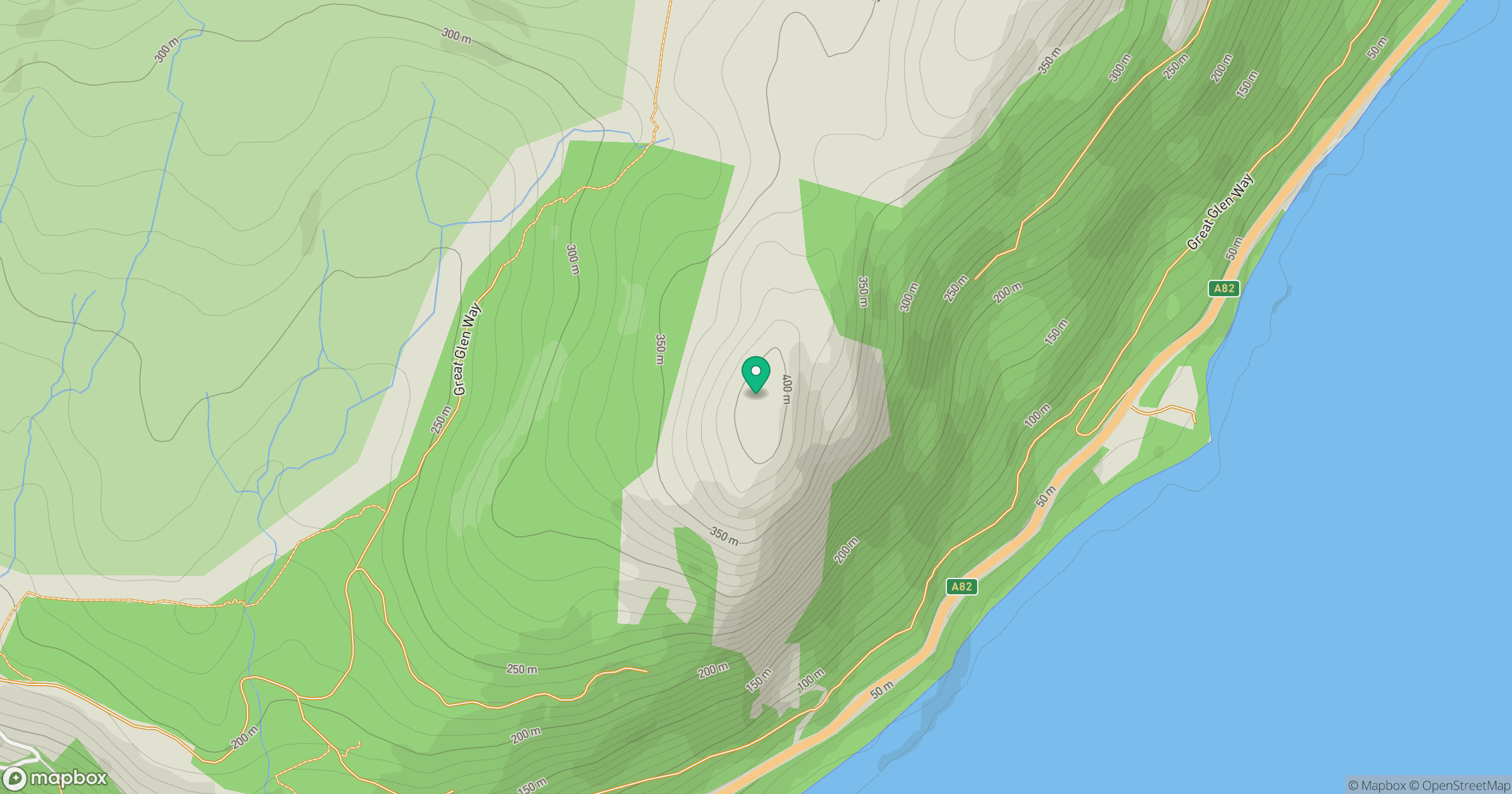
Grid reference: NH437176
View on OpenStreetMapOpens a map in a new tab, centred on the hill.
Hills within 30 km
Straight-line distance, not a walking route or confirmation of access.
No comments yet. Be the first.