

Lewesdon Hill
Good walks are even better shared.
ST4300 : Descending Lewesdon Hill
Michael Graham Photo source
Overview
Lewesdon Hill
Overview
Lewesdon Hill, standing at an impressive 279 meters, is the highest point in Dorset and offers a delightful escape for hikers and outdoor enthusiasts alike. Nestled amidst the lush landscapes of the Blackmore Vale, this Marilyn attracts visitors with its stunning views and rich history.
Geology
The geology of Lewesdon Hill is quite intriguing. Composed mainly of limestone and clay, it showcases sedimentary layers that provide a glimpse into the earth's geological history. The fascinating formations make it a perfect spot for budding geologists and casual hikers interested in natural science.
Routes
For those considering a hike, the Lewesdon Hill Circular Route is highly recommended. This scenic 5 km trail meanders through whimsical woodlands and rolling hills, making it a lovely jaunt for families or casual walkers. Alternatively, if you’re feeling sprightly, the Direct Ascent from Lewesdon Hill Car Park is a brisk path encompassing 1.5 km, leading you conveniently to the summit where you can catch your breath and enjoy the views.
Summit Features
At the summit, you’ll be greeted by a sturdy trig point, perfect for a quick selfie, along with a quaint stone bench that beckons you for a rest. Remember to bring your picnic to enjoy the splendours of nature!
Terrain Type
Expect a mix of grassy slopes with rocky outcrops; it's an easy stroll for the most part, but the odd rocky patch keeps things interesting!
Views
The summit rewards you handsomely with breathtaking panoramic views. Look out towards the Blackmore Vale and, on especially clear days, the distant Isle of Portland is visible, making it worth the trek. For the best views, visit during spring or autumn when the landscape is at its finest.
Hazards
As with any adventure, there are a few pitfalls to keep in mind. Be cautious of slippery spots after rain and steer clear of livestock that may be roaming in the fields. Your hiking boots will thank you!
Nearby Summits
If you’re feeling adventurous, consider tackling Pilsdon Pen or Cranborne Chase, two nearby summits that can easily be included in a day’s itinerary.
Access
The closest parking can be found at Lewesdon Hill Car Park, which is conveniently located at ST433010. Should you prefer public transport, Beaminster is your best bet, with regular bus services connecting you to local stops.
Facilities
After your hike, you can indulge in a hearty piece of cake or grab a refreshing drink at one of Beaminster's cafes. Keep an eye out for those public toilets, too—just in case!
History
The name 'Lewesdon' harks back to its Old English origins, meaning 'hill of the people'. This area has served as both a grazing ground and a route for ancient traders of yore, making it a point of cultural interest as well.
In summary, Lewesdon Hill is a delightful hike for all skill levels, offering a blend of stunning landscapes, interesting geology, and a sprinkle of historical charm. Don’t forget your camera and, most importantly, your sense of adventure!
Happy hiking!
Explore routes near Lewesdon Hill
Walks starting near this hill. Open a route to check its map, distance and full itinerary.
Langdon Hill Circular
View route
Dorchester Walk with Men Walking & Talking
View route
Hardy's Cottage, Stinsford and Dorchester from Thorncombe Wood
View route
Taunton Walk with Men Walking & Talking
View route
Route planning notes
These notes describe possible approaches. Check a route's map and access information when planning your walk.
Lewesdon Hill Circular Route
A scenic circular route starting from the village of Beaminsters, providing a well-marked path through woodlands and rolling hills.
Direct Ascent from Lewesdon Hill Car Park
A direct path leading straight to the summit, perfect for those who prefer a less winding route.
Make a day of it, together
Find someone to share the walk with, or organise a day out along a route you like.
Photo Gallery
View all Photo could not load
ST4300 : Descending Lewesdon Hill
Michael Graham
 Photo could not load
ST4301 : Lewesdon Hill
Richard Webb
 Photo could not load
ST4301 : Summit of Lewesdon Hill
Roger Cornfoot
 Photo could not load
ST4301 : Porcelain fungus
Roger Cornfoot
 Photo could not load
ST4301 : Lewesdon Hill
Richard Webb
 Photo could not load
ST4301 : Fallen tree, near Lewesdon Hill
Roger Cornfoot
 Photo could not load
ST4301 : On Lewesdon Hill
Michael Graham
 Photo could not load
ST4301 : Summit of Lewesdon Hill on a July evening
Maurice D Budden
 Photo could not load
ST4301 : Summit area of Lewesdon Hill
Trevor Littlewood

ST4301 : Lewesdon Hill
Rude Health
Hill facts and local notes
Classifications
Elevation
279m
914 ft
Prominence
187m
Coordinates
50.8073, -2.7994
ST437011
OS Map
193
Explorer: 116
At the Summit
The summit features a trig point that offers a perfect spot for photos, and a small stone bench for those who wish to relax and take in the view.
Terrain & Geology
The hill is primarily composed of limestone and clay, offering a fascinating mix of geological features, including sedimentary layers that tell a story of millions of years of geological activity.
Views & Scenery
Stunning panoramic views of the surrounding Blackmore Vale and the distant heights of the Quantock Hills. On a clear day, the views extend to the Isle of Portland.
History & Heritage
Name Origin
The name 'Lewesdon' is derived from the Old English words meaning 'hill of the people'.
Historical Significance
Historically, the hill has been a site for sheep grazing and has links to ancient trade routes.
Getting There & Facilities
Parking
Lewesdon Hill Car Park, located at ST433010, providing ample space for vehicles.
Public Transport
Buses are available from nearby towns to Beaminster, followed by a short walk to the starting point.
Nearby Facilities
The nearest facilities are in Beaminster, where you can find cafes, shops, and public toilets.
Safety Information
Known Hazards
- Be cautious of muddy paths during wet conditions, and watch out for livestock in the fields.
General Safety Tips
- Check weather conditions before setting out
- Carry appropriate clothing and equipment
- Let someone know your planned route
- Take a map, compass, and GPS device
- Carry emergency supplies: food, water, first aid kit, torch
Hills
Some common questions about the hills answered
Are there group walks up Lewesdon Hill?
Many walkers use Walkmates to join or organise walks with others. You can check for group walks around Lewesdon Hill through the maps
Are there other walkers around Lewesdon Hill?
Activity varies by location and time, but Walkmates lets you see whether others have shared walks or shown interest in this area. Find other people through the walking friends search walking friends for Lewesdon Hill search or of course create your own walk for Lewesdon Hill
Can I organise a walk to Lewesdon Hill?
Yes. If there aren’t any walks listed already, you can create a walk and make it available for others to join.
If you're signed up to Walkmates, you can create a walk to Lewesdon Hill.
How do I find a walk up this hill?
There are often multiple ways to walk this hill, depending on experience and route preference. Walkmates helps you explore walks and routes that others have shared.
Can I suggest a new route up Lewesdon Hill?
Yes. You can suggest or create routes to share with others. Walkmates focuses on the social side of walking, so routes are used to help people organise walks and explore areas together, rather than as detailed navigation tools or route libraries.
Other uses really appreciate knowledgeable walkers sharing their routes. Share your favourite route to Lewesdon Hill here
The is an error or something incorrect about this hill. How do I let you know?
We always strive to keep the information on Walkmates as accurate as possible. If you find an error, please let us know through the contact form and we'll aim to correct it as quickly as possible
Community Discussion
Comments
Location
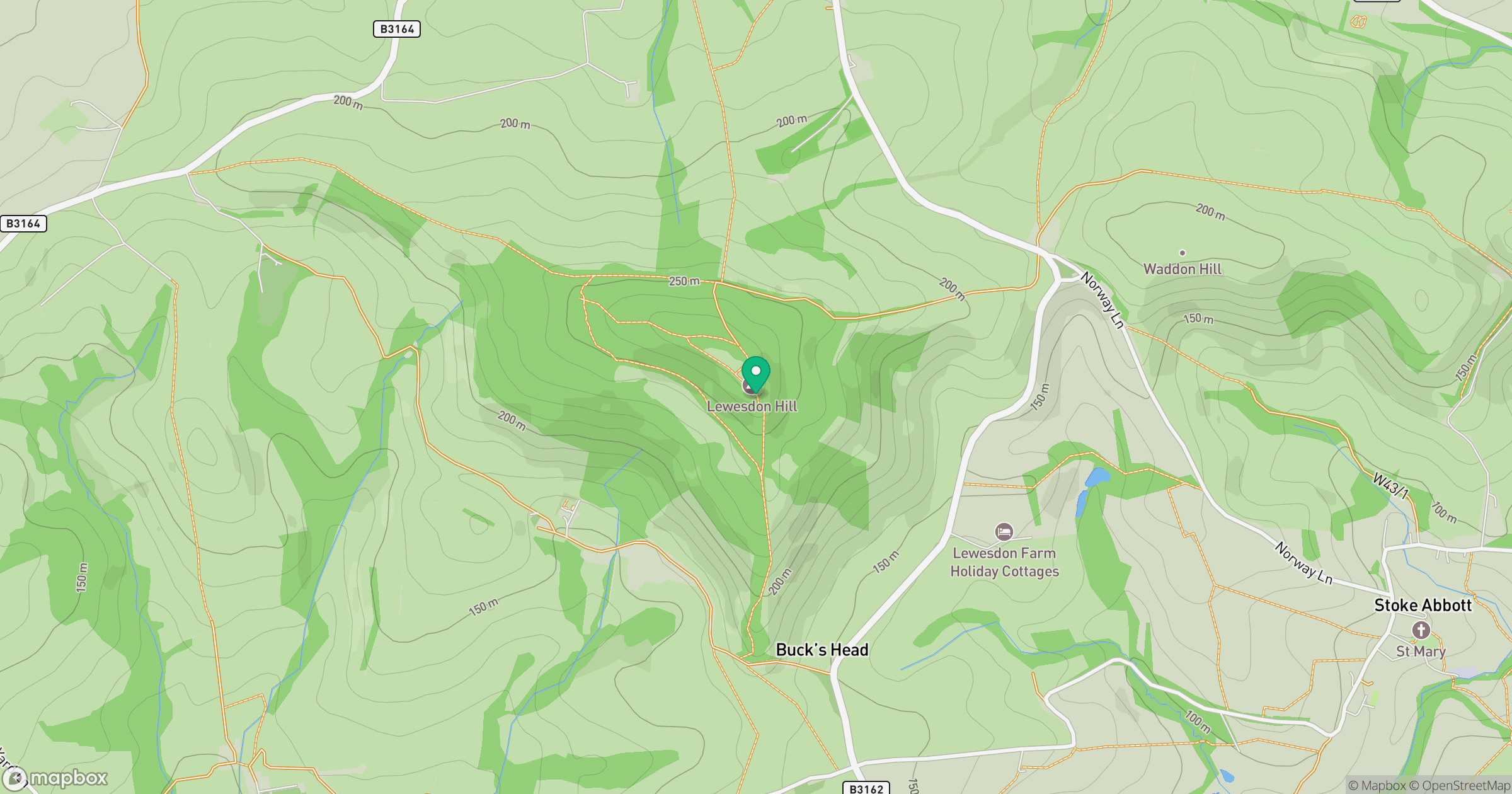
Grid reference: ST437011
View on OpenStreetMapOpens a map in a new tab, centred on the hill.
No comments yet. Be the first.