

North Berwick Law
Good walks are even better shared.
NT5584 : Trig Point on North Berwick Law & view west
Colin Park Photo source
Overview
North Berwick Law is a 187 m volcanic hill beside North Berwick in East Lothian, with views across the Firth of Forth. Its summit has a trig point and replica whale-jawbone arch. The signed ascent is short but steep, with uneven rock underfoot; longer walks can include the town and coast.
North Berwick Law
North Berwick Law rises to 187 m beside the East Lothian town of North Berwick. Its 168 m prominence makes it a Marilyn. This is a steep hill walk with uneven ground, even though the hill is close to town.
Walking options
The main summit path starts at the Law car park off the B1347, grid reference NT553842. Plantlife’s guide describes a one-mile return: follow the signed main path to the summit and descend the same way. It does not give a walking time. Avoid informal shortcuts, which damage the hill’s grassland and can be steeper.
The separate Walkhighlands town-and-coast circuit is 6.75 km, with 198 m ascent and a published time of 2–2.5 hours. It continues through the Glen, along the coast and through town before returning to the car park. See the route description for its full sequence and return.
Summit and landscape
A trig point, viewpoint indicator and replica whale-jawbone arch stand at the summit. The natural high point is rock beside the trig point. The hill is a volcanic plug subsequently shaped by glacial erosion. Visibility permitting, the outlook takes in the Firth of Forth, Bass Rock and distant Edinburgh hills.
Heritage
Prehistoric fort remains, hut circles and enclosures survive on the hill, alongside later lookout structures. Historic Environment Scotland records the prehistoric site as scheduled monument SM3863.
Access and care
Use the signed B1347 car park or walk from North Berwick. Trains link the town with Edinburgh. Toilets and refreshments are in town, rather than at the hill. Check current transport, parking and path notices.
The ascent and descent include rocky, uneven and slippery ground. Wear suitable footwear, keep to the main path and turn back if conditions exceed your experience. The low summit height does not make this a level or universally easy walk.
Explore routes near North Berwick Law
Walks starting near this hill. Open a route to check its map, distance and full itinerary.
Cottyburn to Haddington: East Lothian Railway Walk return
View route
Cockburnspath to Dunglass Dean and Old Bridge
View route
Dalkeith Country Park: Estate and North Woods Green Trail
View route
To Absent Friends: Holyrood Park walk
View route
Route planning notes
These notes describe possible approaches. Check a route's map and access information when planning your walk.
North Berwick Law from the car park (return)
From the Law car park off the B1347 (NT553842), follow the signed main path to the summit and retrace it to the car park. Plantlife describes a one-mile return, with steep, strenuous climbing and rocky, slippery or uneven sections. Keep to the signed path rather than informal shortcuts. This summit outing is separate from the longer town-and-coast circuit.
North Berwick Law, town and coast circuit
From the Law car park (B1347, NT553842), follow the signed path to the summit and retrace the upper path. Continue around the lower hillside to the housing and supermarket, cross the A198 to the Glen and follow the burn to the coast. Return via St Andrew’s Old Kirk, Seabird Centre, harbour, Quality Street, Lodge Grounds and John Muir Way links. Walkhighlands gives 6.75 km, 198 m ascent and 2–2.5 hours for this complete circuit. Some paths are steep, rough or boggy.
Make a day of it, together
Find someone to share the walk with, or organise a day out along a route you like.
Photo Gallery
View all Photo could not load
NT5584 : Trig Point on North Berwick Law & view west
Colin Park
 Photo could not load
NT5584 : Summit of North Berwick Law
John Allan
 Photo could not load
NT5584 : Summit of North Berwick Law
John Allan
 Photo could not load
NT5584 : Replica whale bone arch on North Berwick Law
Colin Park
 Photo could not load
NT5584 : North Berwick Law from the air
James Allan
 Photo could not load
NT5584 : East Lothian Landscape : The View South-East From North Berwick Law
Richard West
 Photo could not load
NT5584 : East Lothian Landscape : The Replacement Whalebone Arch On North Berwick Law
Richard West
 Photo could not load
NT5584 : Whale's Jaw Bone, North Berwick Law
Graeme Yuill
 Photo could not load
NT5584 : A ruined building at the summit area of North Berwick Law
Walter Baxter

NT5584 : North Berwick Law
Walter Baxter
Hill facts and local notes
Classifications
Elevation
187m
614 ft
Prominence
168m
Coordinates
56.0488, -2.7138
NT556842
OS Map
66
Explorer: 351E
At the Summit
The summit has a trig point, a viewpoint indicator and a fibreglass replica whale-jawbone arch. DoBIH records the natural high point as rock 3 m northeast of the trig point, on the same rocky summit outcrop.
Terrain & Geology
North Berwick Law is a resistant volcanic plug of phonolitic trachyte, formed during Carboniferous volcanic activity. Glacial erosion later shaped the hill into a crag-and-tail landform, with a tail extending eastwards. The surviving cone reflects both its volcanic origin and later erosion.
Views & Scenery
In clear weather the summit overlooks North Berwick and the Firth of Forth, including Bass Rock and other offshore islands. Views also extend towards Arthur’s Seat and the Pentland Hills to the west.
History & Heritage
Name Origin
Law is a Scots word for a rounded or conical hill, derived from Old English hlāw. The Dictionaries of the Scots Language gives Berwick Law as an example.
Historical Significance
The hill preserves a prehistoric fort, hut circles and enclosures, protected as scheduled monument SM3863. Later remains include Napoleonic-era lookout buildings and wartime observation structures. A whale-jawbone landmark has stood here since 1709; the present fibreglass replica was installed in 2008.
Getting There & Facilities
Parking
The signed Law car park is off the B1347 on the west side of the hill, at approximately NT553842. Check current signs for parking restrictions and any charges. Town-centre parking has separate charging and maximum-stay rules; do not assume spaces are available near the harbour.
Public Transport
ScotRail trains connect Edinburgh and North Berwick, and buses serve the town. East Lothian Council describes the hill as about a 20-minute walk from the station. Allow extra time for the summit climb and check current rail and bus timetables before travelling.
Nearby Facilities
There are no toilets at the Law. North Berwick has public toilets, cafés, shops and places to eat; check opening hours before relying on them.
Safety Information
Known Hazards
- The summit path is steep, rocky and uneven; mud and wet rock can be slippery, especially on the descent.
- Stay on the signed main path to limit erosion and avoid steeper informal shortcuts.
- Choose conditions that suit your ability and wear footwear with good grip. Turn back if strong wind or poor visibility makes the ascent or descent unsafe.
General Safety Tips
- Check weather conditions before setting out
- Carry appropriate clothing and equipment
- Let someone know your planned route
- Take a map, compass, and GPS device
- Carry emergency supplies: food, water, first aid kit, torch
Hills
Some common questions about the hills answered
Are there group walks up North Berwick Law?
Many walkers use Walkmates to join or organise walks with others. You can check for group walks around North Berwick Law through the maps
Are there other walkers around North Berwick Law?
Activity varies by location and time, but Walkmates lets you see whether others have shared walks or shown interest in this area. Find other people through the walking friends search walking friends for North Berwick Law search or of course create your own walk for North Berwick Law
Can I organise a walk to North Berwick Law?
Yes. If there aren’t any walks listed already, you can create a walk and make it available for others to join.
If you're signed up to Walkmates, you can create a walk to North Berwick Law.
How do I find a walk up this hill?
There are often multiple ways to walk this hill, depending on experience and route preference. Walkmates helps you explore walks and routes that others have shared.
Can I suggest a new route up North Berwick Law?
Yes. You can suggest or create routes to share with others. Walkmates focuses on the social side of walking, so routes are used to help people organise walks and explore areas together, rather than as detailed navigation tools or route libraries.
Other uses really appreciate knowledgeable walkers sharing their routes. Share your favourite route to North Berwick Law here
The is an error or something incorrect about this hill. How do I let you know?
We always strive to keep the information on Walkmates as accurate as possible. If you find an error, please let us know through the contact form and we'll aim to correct it as quickly as possible
Community Discussion
Comments
Location
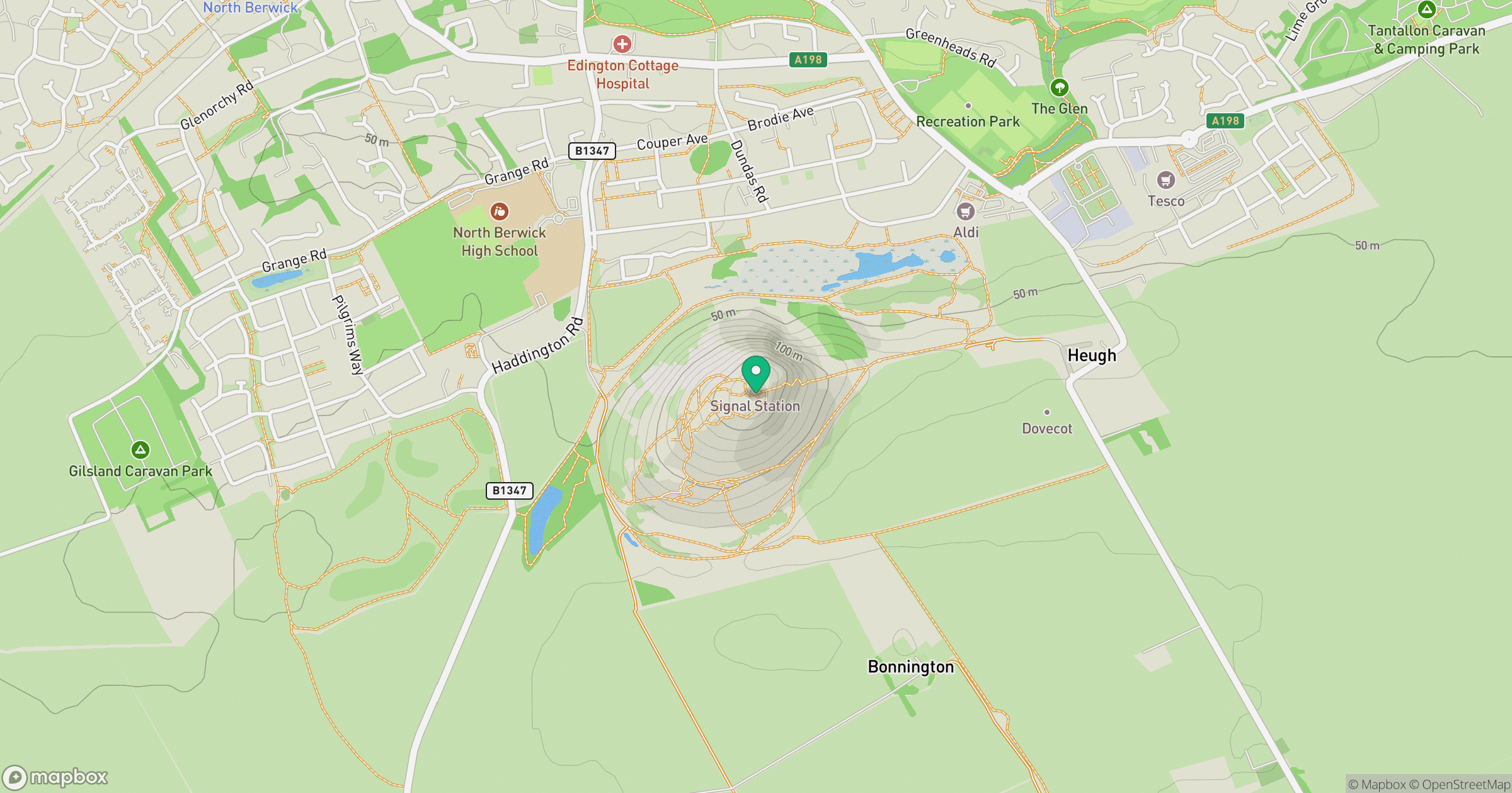
Grid reference: NT556842
View on OpenStreetMapOpens a map in a new tab, centred on the hill.
No comments yet. Be the first.