
Holne Chase
Good walks are even better shared.
Overview
Holne Chase
Located in the heart of Dartmoor National Park, Holne Chase is a gem waiting to be explored. Standing at an elevation of 367 meters, this mountain isn’t the tallest on Dartmoor, but its charm and picturesque surroundings make it a favourite among outdoor adventurers.
Geology
Holne Chase showcases the classic Devonian granite of Dartmoor. With its rugged formations and scattered boulders, the area tells the tale of millennia of geological processes. The granite outcrops create unique habitats that support diverse flora and fauna. This is a great spot to take a closer look; you never know what interesting rocks you might stumble upon!
Routes
One popular option is the Holne Chase Circular Walk, a delightful 7.5 km trek that will take you through enchanting woodlands, rolling moorland, and along the scenic River Dart. Allow about 2.5 hours to enjoy its views and maybe even grab a snack at one of the perfect picnic spots along the way. This route is rated as Moderate; a bit of a leg stretch, but nothing that will send you panting for the hills.
Summit Features
At the summit, you'll be welcomed by a large granite boulder, often referred to as 'the throne of Holne Chase'. This rocky perch provides the perfect spot for a photo op - just make sure you’re not photobombed by any sheep!
Terrain
Expect a mix of moorland, rocky outcrops, and grassy patches. Some sections may get boggy after a good rain, so sturdy boots are recommended. After all, who wants squelchy socks ruining their day?
Views
From the summit, expansive views unfold. On a clear day, take in the breathtaking vistas over the Dart Valley, rolling hills, and if you’re feeling particularly lucky, a glimpse of the coast off in the distance. Spring and autumn offer the best views, with a riot of colours greeting you at every turn.
Hazards
Moorland can be slippery when wet—think of it as Dartmoor’s way of giving you a free spa treatment. Be sure to carry a map and compass; the weather can change faster than a pub quiz on a Saturday night, and visibility can drop in an instant.
Nearby Summits
For those who want to keep the adventure going, Hound Tor and Great Mis Tor are just a short distance away and worth the extra effort.
Access
Parking can be found at the Holne Chase car park (SX 718 704). The nearest town, Ashburton, is approximately 5 km away, and it has several cafes and shops to refuel after your hike. Buses also run from Ashburton to Holne, providing easy access for those relying on public transport.
Facilities
Although there are no facilities directly on Holne Chase, Ashburton offers various amenities including cafes, shops, and public toilets. Just remember to hydrate and nibble a little something before venturing out into the wild!
History
The name 'Holne' comes from the Old English word 'holin', meaning 'hollow', a nod to the dips and valleys of the area. Holne Chase has been an important site throughout history, with assorted archaeological finds dating back to prehistoric times, hinting at the long-standing connection of people to this enchanting landscape.
In summary, Holne Chase offers a delightful escape into nature, with plenty of stunning views, interesting geology, and a good measure of adventure. Just remember to tread lightly and take it all in—you never know what surprises nature might have in store!
Explore routes near Holne Chase
Walks starting near this hill. Open a route to check its map, distance and full itinerary.
Moretonhampstead to Lustleigh: Wray Valley woodland railway trail
View route
Castle Drogo and Fingle Bridge: Teign Gorge woodland circuit
View route
Exeter Canal, Double Locks and Countess Wear river circuit
View route
Cotehele: Danescombe Valley and Mining Heritage Circuit
View route
Route planning notes
These notes describe possible approaches. Check a route's map and access information when planning your walk.
Holne Chase Circular Walk
A beautiful circular route around Holne Chase, combining woodland, open moorland, and the stunning River Dart.
Make a day of it, together
Find someone to share the walk with, or organise a day out along a route you like.
Hill facts and local notes
Classifications
Elevation
198m
650 ft
Prominence
50m
Coordinates
50.5306, -3.8034
SX722716
OS Map
202
Explorer: OL28S
At the Summit
The summit features a large granite boulder that provides an excellent viewpoint, often referred to as 'the throne of Holne Chase'.
Terrain & Geology
Holne Chase is primarily composed of Devonian granite, which is renowned for its rugged resilience and distinctive boulders, perfect for both climbers and flora enthusiasts. The area showcases typical Dartmoor granite scenery, complete with fascinating tors and wooded valleys.
Views & Scenery
From the summit, you can enjoy panoramic views over the Dart Valley, the rolling hills of Dartmoor, and on a clear day, even glimpse the distant coast.
History & Heritage
Name Origin
The name 'Holne' is derived from the Old English word 'holin', meaning 'hollow'.
Historical Significance
Historically, the area has been used for farming and is rich in archaeological sites dating back to prehistoric times.
Getting There & Facilities
Parking
Parking is available at the Holne Chase car park (SX 718 704), which provides easy access to the trails.
Public Transport
Buses run from Ashburton to Holne; check local timetables for current service details.
Nearby Facilities
There are no facilities directly at Holne Chase, but nearby Ashburton offers cafes, shops, and public toilets.
Safety Information
Known Hazards
- Moorland can be slippery when wet, and visibility can drop rapidly in fog. Always carry a map and compass, as GPS can be unreliable in the area.
General Safety Tips
- Check weather conditions before setting out
- Carry appropriate clothing and equipment
- Let someone know your planned route
- Take a map, compass, and GPS device
- Carry emergency supplies: food, water, first aid kit, torch
Hills
Some common questions about the hills answered
Are there group walks up Holne Chase?
Many walkers use Walkmates to join or organise walks with others. You can check for group walks around Holne Chase through the maps
Are there other walkers around Holne Chase?
Activity varies by location and time, but Walkmates lets you see whether others have shared walks or shown interest in this area. Find other people through the walking friends search walking friends for Holne Chase search or of course create your own walk for Holne Chase
Can I organise a walk to Holne Chase?
Yes. If there aren’t any walks listed already, you can create a walk and make it available for others to join.
If you're signed up to Walkmates, you can create a walk to Holne Chase.
How do I find a walk up this hill?
There are often multiple ways to walk this hill, depending on experience and route preference. Walkmates helps you explore walks and routes that others have shared.
Can I suggest a new route up Holne Chase?
Yes. You can suggest or create routes to share with others. Walkmates focuses on the social side of walking, so routes are used to help people organise walks and explore areas together, rather than as detailed navigation tools or route libraries.
Other uses really appreciate knowledgeable walkers sharing their routes. Share your favourite route to Holne Chase here
The is an error or something incorrect about this hill. How do I let you know?
We always strive to keep the information on Walkmates as accurate as possible. If you find an error, please let us know through the contact form and we'll aim to correct it as quickly as possible
Community Discussion
Comments
Location
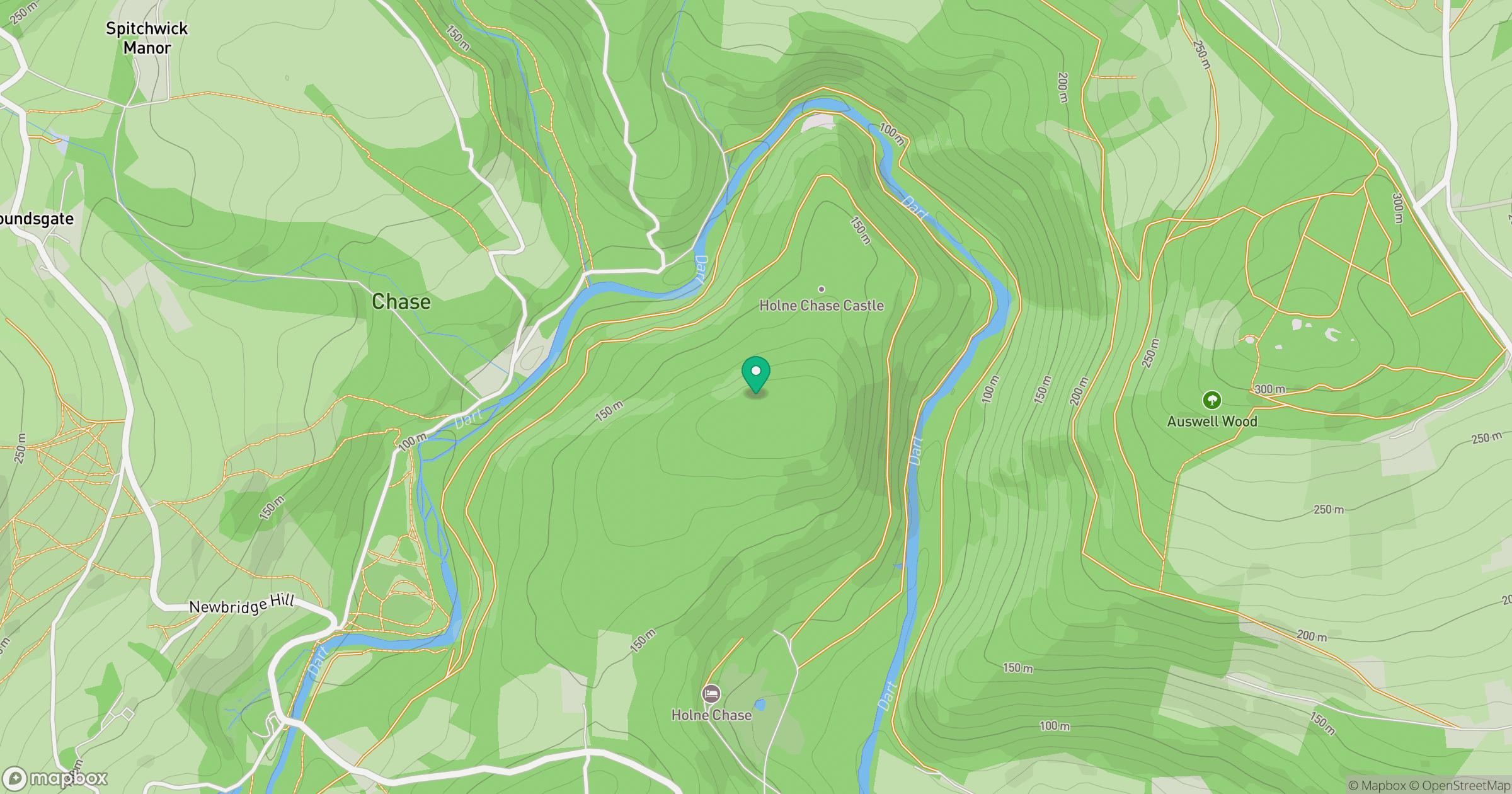
Grid reference: SX722716
View on OpenStreetMapOpens a map in a new tab, centred on the hill.
Nearby Hills

High Willhays
622m

Brent Tor
334m

Dunkery Beacon
520m
Brown Willy
420m
Rhossili Down - The Beacon
193m
No comments yet. Be the first.