

Hindleap Hill
Good walks are even better shared.
Overview
Hindleap Hill
Hindleap Hill is a delightful spot for hikers of all abilities, standing at an elevation of 197 meters within the scenic South Downs National Park.
Geology
This area showcases the Wealden geologic formation, which comprises clay and sandstone layers, resulting in captivating scenery and fertile ground for local flora. The hill's surface is mostly grassy, with a few rocky patches that might catch you unaware—so mind your footing!
Routes
Two popular routes lead to the summit:
- Hindleap Hill Circular Walk: This moderate trail begins at Ditchling Common and loops around the hill, providing plenty of opportunities to appreciate the surrounding woodlands.
- Ditchling Beacon to Hindleap Hill: A vibrant jaunt that connects to a nearby high point, offering splendid panoramic views along the way.
Summit Features
At the summit, you'll find an undulating grass mound with sweeping vistas. Apart from the occasional cow contemplating life, there is no significant structure, but nature's beauty steals the show here.
Terrain Type
Prepare for a grassy summit and inviting woodland paths, mingled with the odd rocky outcrop that reminds you you’re actually in the hills!
Views
The views from Hindleap Hill are the icing on the cake. You can take in the rolling hills of East Sussex and, on a clear day, even spot the famous Isle of Wight in the distance. Truly a sight to behold!
Visiting in spring or autumn is highly recommended, as you'll be treated to flowering displays or fiery autumn leaves.
Hazards
Be cautious of muddy paths after rainfall, and don't be surprised if you share the trail with some curious cows grazing nearby. They can be quite the characters!
Nearby Summits
Don’t miss a chance to visit Ditchling Beacon or Black Cap, both offering additional hiking experiences and views worth their weight in gold.
Access
You can park at Ditchling Common, just a stone’s throw away from the path. Convenient transport links to Ditchling from Brighton are also available, making it an easily accessible outdoor getaway.
Facilities
While you won’t find facilities at the summit, Ditchling has plenty of delightful cafés and shops to refuel after your adventure.
History
Curiously, the name 'Hindleap' suggests a hidden spot where one might leap in joy, and its historical significance has made it a cherished destination among hikers.
So, lace up those boots and get ready to explore Hindleap Hill! Whether you're scanning the horizon or helping a cow with their existential crisis, nature has something in store for you.
Explore routes near Hindleap Hill
Public walks starting within 80 km of this hill. Nearby does not mean a route reaches the summit; check its map and access before setting out.
Twilight wildlife walk at Old Lodge
View route
Forest Way: Herontye Drive to Corseley Road
View route
Ashdown Forest Wellington Crash Site and Airman's Grave
View route
Worth Way: East Grinstead to Three Bridges Station
View route
Route planning notes
These notes describe possible approaches, not verified navigable routes or permission to cross land. Check current paths, local access rules and conditions before setting out.
Hindleap Hill Circular Walk
An enjoyable circular route starting from Ditchling Common, which takes you around the hill and back through beautiful woodlands.
Ditchling Beacon to Hindleap Hill
A scenic hike connecting the nearby Ditchling Beacon with Hindleap Hill, offering breathtaking views along the South Downs Way.
Make a day of it, together
Find someone to share the walk with, or organise a day out along a route you like.
Photo Gallery
View all Photo could not load
TQ4132 : Ashdown Forest
Simon Carey
 Photo could not load
TQ4132 : Hindleap Lane
Oast House Archive
 Photo could not load
TQ4132 : Ride, Ashdown Forest
Robin Webster
 Photo could not load
TQ4132 : Parking area off Hindleap Lane
Oast House Archive
 Photo could not load
TQ4132 : Herring-bone tree
Robin Webster
 Photo could not load
TQ4132 : Pines, Ashdown Forest
Robin Webster
 Photo could not load
TQ4132 : Birches by the car park at Wych Cross
Dave Spicer
 Photo could not load
TQ4132 : Clump of trees surrounding car park on Hindleap Lane
Dave Spicer
Hill facts and local notes
Classifications
Elevation
203m
666 ft
Prominence
66m
Coordinates
51.0708, 0.0170
TQ414320
OS Map
187 198
Explorer: 135
At the Summit
The summit features a simple grassy mound with an expansive view. There’s no trig point, but the lack of obstructions ensures panoramic views.
Terrain & Geology
Hindleap Hill is primarily composed of Wealden clay and sandstone, providing a mix of sturdy footing and a few slippery patches when wet. The landscape is shaped by the characteristic rolling hills of the South Downs.
Views & Scenery
From the summit, you can see the rolling landscapes of East Sussex, the distant waves of the English Channel, and on a clear day, even as far as the Isle of Wight.
History & Heritage
Name Origin
The name 'Hindleap' likely derives from the old English words for 'hidden leap', reflecting its secluded position amidst the hills.
Historical Significance
Hindleap Hill, with its natural beauty, has long been a beloved walking destination for locals and nature enthusiasts alike.
Getting There & Facilities
Check current local access restrictions, parking rules and transport timetables before travelling. These notes do not confirm public access to the summit.
Parking
Ditchling Common car park is the nearest, with ample space. Just a short walk to the trailhead.
Public Transport
Regular bus services run to Ditchling from Brighton; check the latest schedules for details.
Nearby Facilities
There are no facilities at the top, but Ditchling offers several cafes and small shops for pre- or post-hike refreshments.
Safety Information
Known Hazards
- The paths can be muddy after rain, and some areas may be slippery. Watch out for livestock on the paths, especially in summer.
General Safety Tips
- Check weather conditions before setting out
- Carry appropriate clothing and equipment
- Let someone know your planned route
- Take a map, compass, and GPS device
- Carry emergency supplies: food, water, first aid kit, torch
Hills
Some common questions about the hills answered
Are there group walks up Hindleap Hill?
Many walkers use Walkmates to join or organise walks with others. You can check for group walks around Hindleap Hill through the maps
Are there other walkers around Hindleap Hill?
Activity varies by location and time, but Walkmates lets you see whether others have shared walks or shown interest in this area. Find other people through the walking friends search walking friends for Hindleap Hill search or of course create your own walk for Hindleap Hill
Can I organise a walk to Hindleap Hill?
Yes. If there aren’t any walks listed already, you can create a walk and make it available for others to join.
If you're signed up to Walkmates, you can create a walk to Hindleap Hill.
How do I find a walk up this hill?
There are often multiple ways to walk this hill, depending on experience and route preference. Walkmates helps you explore walks and routes that others have shared.
Can I suggest a new route up Hindleap Hill?
Yes. You can suggest or create routes to share with others. Walkmates focuses on the social side of walking, so routes are used to help people organise walks and explore areas together, rather than as detailed navigation tools or route libraries.
Other uses really appreciate knowledgeable walkers sharing their routes. Share your favourite route to Hindleap Hill here
The is an error or something incorrect about this hill. How do I let you know?
We always strive to keep the information on Walkmates as accurate as possible. If you find an error, please let us know through the contact form and we'll aim to correct it as quickly as possible
Community Discussion
Comments
Location
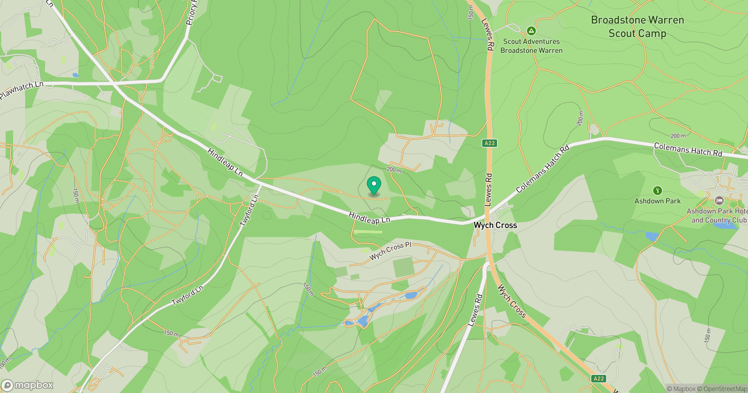
Grid reference: TQ414320
View on OpenStreetMapOpens a map in a new tab, centred on the hill.
Hills within 30 km
Straight-line distance, not a walking route or confirmation of access.
No comments yet. Be the first.