

Grandtully Hill
Good walks are even better shared.
Overview
Grandtully Hill: Your Next Hiking Adventure!
Nestled in the heart of Central Scotland, Grandtully Hill stands at 313 meters high. It's classified as a Marilyn, which means it’s a hill with a prominence of at least 150 meters—yes, it does hold its head high amongst its peers!
Getting There
Finding your way to this hidden gem is a breeze. The closest nearest town is Aberfeldy, just around 8 km away. Once you gear up, make your way to the nearby parking near the Grandtully village hall. But heed the warning: it can fill up faster than you can tie your shoelaces on a summer weekend!
Should you prefer the thrill of public transport, you can hop on a bus to Aberfeldy, and then stretch your legs with a 10 km walk to your hiking paradise.
The Route
For a delightful experience, attempt the West Balquhidder Route. This 4.5 km trail takes you through luscious woodlands before leading you to the summit, and should take approximately 1.5 hours to complete. It’s rated moderate, so prepare for a nice workout without completely wearing out those calf muscles!
The Summit
When you reach the top, there’s a small cairn waiting to celebrate your victory. Grab a seat and soak in the stunning views—on a clear day, you can spot the alluring hills of the Grampians and the meandering twists of the River Tay far below. Don’t forget to take plenty of snaps, and perhaps a selfie (or three)! As for the best seasons to hike? Spring and early autumn are prime time for clearer views, while summer provides that dazzling green landscape…just be sure to stock up on insect repellent for those pesky midges!
Hazards to Keep in Mind
Like any outdoor adventure, Grandtully Hill has its quirks. Be vigilant of the uneven terrain, especially after rain, as it can become quite slippery. And let's not forget Mother Nature's unpredictable whims; dress in layers and be prepared for rapid weather changes.
Nearby Adventures
If you’re feeling particularly ambitious, consider tackling Ben Lawers, which rises majestically to 1214 meters just a stone's throw away from Grandtully Hill. What a way to impress your fellow hikers!
Wrap-Up
In summary, Grandtully Hill is a superb spot for both novice and experienced hikers. With charming wildlife, rich history, and breathtaking views, this hill proves that great things come in small packages.
So lace up those boots, pack your sandwiches, and embrace the great Scottish outdoors!
Last Updated: 2023-10-01
Explore routes near Grandtully Hill
Public walks starting within 80 km of this hill. Nearby does not mean a route reaches the summit; check its map and access before setting out.
Aberfeldy: Glassie Woodland and River Tay Circular
View route
Kenmore: Drummond Hill Black Rock Trail above Loch Tay
View route
Glen Banvie Trail with the Bruar viewpoint
View route
Crieff: Lady Mary's Walk and the River Earn
View route
Route planning notes
These notes describe possible approaches, not verified navigable routes or permission to cross land. Check current paths, local access rules and conditions before setting out.
West Balquhidder Route
This route starts at the village of Grandtully and follows a well-defined path that meanders through beautiful woodlands before ascending to the summit.
Make a day of it, together
Find someone to share the walk with, or organise a day out along a route you like.
Photo Gallery
View all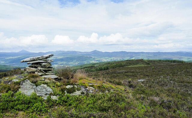 Photo could not load
NN9147 : Heather moorland of Grandtully Hill
Trevor Littlewood
Hill facts and local notes
Classifications
Elevation
532m
1,745 ft
Prominence
135m
Coordinates
56.6078, -3.7754
NN911476
OS Map
52
Explorer: 379W
At the Summit
The summit boasts a small cairn, which serves as a perfect perch for a scenic picnic, alongside sweeping views of the surrounding countryside.
Terrain & Geology
Primarily composed of sedimentary rock, Grandtully Hill exhibits fascinating layers of sandstone and shale that tell a story of ancient seabeds and geological upheaval.
Views & Scenery
From the summit, you can enjoy picturesque views of the Tay Forest Park, the River Tay, and the distant peaks of the Grampians.
History & Heritage
Name Origin
The name 'Grandtully' is derived from Gaelic, meaning 'the hill of the grove', which invites hikers to appreciate its verdant beauty.
Historical Significance
Historically, this area was significant for lumber and agriculture, and it continues to hold importance for outdoor recreation.
Getting There & Facilities
Check current local access restrictions, parking rules and transport timetables before travelling. These notes do not confirm public access to the summit.
Parking
There is a small parking area near the Grandtully village hall. Arrive early as it can fill up quickly on weekends.
Public Transport
The nearest public transport is a bus service connecting to Pitlochry. From there, it's a 10 km walk to reach the starting point.
Nearby Facilities
Aberfeldy offers several cafes, restaurants, and public toilets—perfect for refueling after your ascent!
Safety Information
Known Hazards
- Uneven terrain can lead to trips and falls, especially in wet conditions. Be wary of sudden weather changes in the hills.
General Safety Tips
- Check weather conditions before setting out
- Carry appropriate clothing and equipment
- Let someone know your planned route
- Take a map, compass, and GPS device
- Carry emergency supplies: food, water, first aid kit, torch
Hills
Some common questions about the hills answered
Are there group walks up Grandtully Hill?
Many walkers use Walkmates to join or organise walks with others. You can check for group walks around Grandtully Hill through the maps
Are there other walkers around Grandtully Hill?
Activity varies by location and time, but Walkmates lets you see whether others have shared walks or shown interest in this area. Find other people through the walking friends search walking friends for Grandtully Hill search or of course create your own walk for Grandtully Hill
Can I organise a walk to Grandtully Hill?
Yes. If there aren’t any walks listed already, you can create a walk and make it available for others to join.
If you're signed up to Walkmates, you can create a walk to Grandtully Hill.
How do I find a walk up this hill?
There are often multiple ways to walk this hill, depending on experience and route preference. Walkmates helps you explore walks and routes that others have shared.
Can I suggest a new route up Grandtully Hill?
Yes. You can suggest or create routes to share with others. Walkmates focuses on the social side of walking, so routes are used to help people organise walks and explore areas together, rather than as detailed navigation tools or route libraries.
Other uses really appreciate knowledgeable walkers sharing their routes. Share your favourite route to Grandtully Hill here
The is an error or something incorrect about this hill. How do I let you know?
We always strive to keep the information on Walkmates as accurate as possible. If you find an error, please let us know through the contact form and we'll aim to correct it as quickly as possible
Community Discussion
Comments
Location
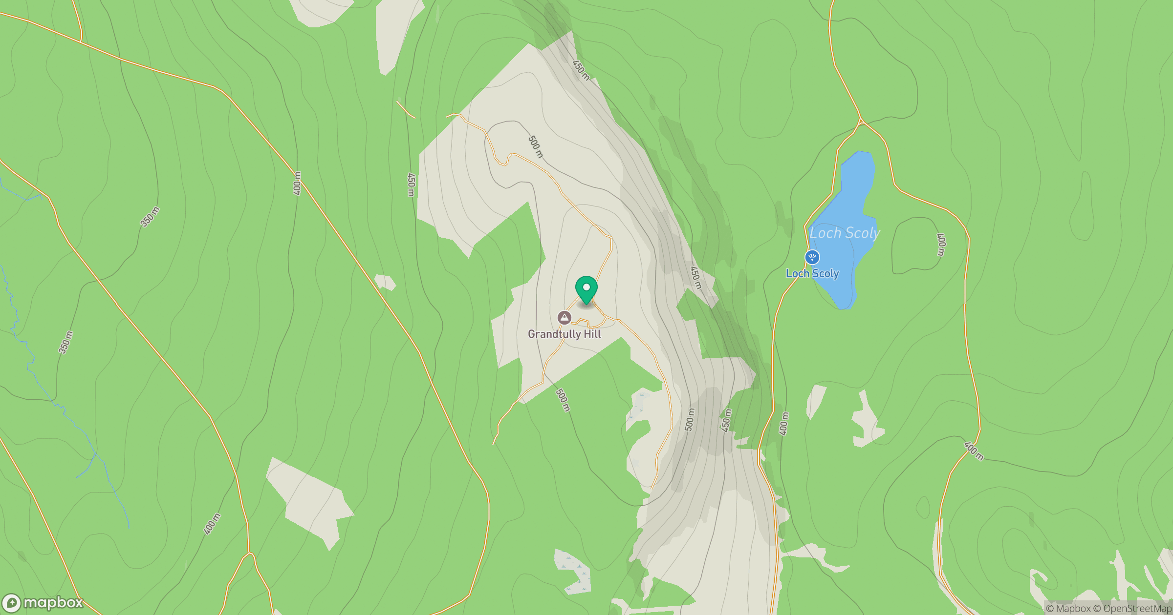
Grid reference: NN911476
View on OpenStreetMapOpens a map in a new tab, centred on the hill.
Hills within 30 km
Straight-line distance, not a walking route or confirmation of access.
Beinn a' Ghlo - Carn Liath
976m
Beinn a' Ghlo - Braigh Coire Chruinn-bhalgain
1,070m
Beinn a' Ghlo - Carn nan Gabhar
1,122m
Schiehallion
1,083m
An Stuc
1,117m
No comments yet. Be the first.