
Cummeen
Good walks are even better shared.
Overview
Cummeen: A Marvelous Marilyn in Donegal
Nestled within the picturesque Donegal Mountains, Cummeen stands proud at an elevation of 536 meters. As a Marilyn, it boasts a distinct prominence that draws the attention of hikers looking to stretch their legs without the drama of a towering Munro.
Geology
If rocks could talk, Cummeen's sandstone layers would regale tales of ancient seas and sedimentary deposits! The geology here provides not just a trek, but a stroll through time. Bounce along these ancient beds and ponder how millions of years have shaped this striking landscape.
The Routes
Ballybofey Route is the most travelled path, weaving through idyllic forests that will have you thinking you're in a fairy tale (minus the elves, hopefully!). At approximately 8 km, it is a moderate route that takes around 3.5 hours. Pack a picnic and prepare for a gradual climb that rewards every effort with sweeping views at the summit.
Summit Features
As you reach the top, you’re greeted by a stone cairn that not only marks your achievement but also provides the perfect backdrop for the obligatory summit selfie. You’ll also find a bench, inviting you to sit back and soak in the breathtaking scenery.
Terrain Type
The terrain is a delightful mix of grassy slopes and rocky outcrops, which teeters precariously on the edge of being 'nature's own adventure course'. Just keep an eye out for those sticky patches of heather trying to trip you up!
Views
From the summit, the vista is truly stunning. You can catch sight of Lough Allen shimmering in the distance, and if you're lucky, the Atlantic Ocean making a cheeky appearance. The best time to appreciate these views? Late spring and autumn—when the air is clear and the colours are positively Instagrammable!
Hazards
Every adventure has its risks. Be sure to watch your step on the wet, slippery rocks, especially after a good rain. And keep your eyes peeled for those sneaky changes in weather that can turn a lovely hike into a surprise shower! Always be prepared.
Access
Starting out from Ballybofey, there's plenty of free parking at the local forest park. Plus, if you prefer not to drive, public transport runs regularly from Donegal Town, and local taxis are always on standby. Convenient!
Facilities
In Ballybofey, you'll find everything from cosy cafes to shops, ensuring you're well-fueled before your hike. Public toilets are also available, because, let's face it, nature calls!
History
The name 'Cummeen', meaning 'the little hill' in Gaelic, may be modest, but don't let that fool you—it is indeed a treasure for hikers! Regionally significant, Cummeen is steeped in folklore, steeped in culture, and remains a cherished destination for those seeking a slice of Donegal adventure.
In conclusion, Cummeen is not just a mountain; it’s an experience waiting to unfold. So lace up those boots, pack your sense of humour, and embark on a journey that promises to be as rewarding as it is invigorating!
Explore routes near Cummeen
Public walks starting within 80 km of this hill. Nearby does not mean a route reaches the summit; check its map and access before setting out.
No public routes are currently listed within 80 km of Cummeen on Walkmates. This does not mean there are no paths here. Explore the map and check local access information before planning a walk.
Route planning notes
These notes describe possible approaches, not verified navigable routes or permission to cross land. Check current paths, local access rules and conditions before setting out.
Ballybofey Route
A scenic route beginning from the village of Ballybofey, winding through lush forests before ascending to the summit.
Make a day of it, together
Find someone to share the walk with, or organise a day out along a route you like.
Hill facts and local notes
Classifications
Elevation
478m
1,568 ft
Prominence
159m
Coordinates
52.2036, -10.0047
Q630076
OS Map
71
At the Summit
At the summit, you'll find a well-constructed stone cairn, offering the perfect photo opportunity. There's also a small bench for those wanting to rest and admire the view.
Terrain & Geology
The mountain is primarily composed of sandstone, with layers indicating ancient sea deposits. The erosion pattern reveals fascinating geological histories, making it a hotspot for geology enthusiasts.
Views & Scenery
On a clear day, expect breathtaking views of the surrounding Donegal countryside, including Lough Allen and the distant Atlantic Ocean.
History & Heritage
Name Origin
The name 'Cummeen' is derived from Gaelic, meaning 'the little hill', which is a fitting description for this charming peak.
Historical Significance
Cummeen holds cultural significance in local folklore and is a popular destination for both locals and tourists seeking adventure.
Getting There & Facilities
Check current local access restrictions, parking rules and transport timetables before travelling. These notes do not confirm public access to the summit.
Parking
Free parking available at the entrance of the Ballybofey forest park, roughly 3 km from the trailhead.
Public Transport
Regular buses operate from Donegal Town to Ballybofey, with local taxis plentiful in the area.
Nearby Facilities
Ballybofey has several cafes, shops, and public toilets available for use before or after your hike.
Safety Information
Known Hazards
- Wet and slippery rocks, especially after rain; be wary of sudden weather changes and ensure you have proper gear.
General Safety Tips
- Check weather conditions before setting out
- Carry appropriate clothing and equipment
- Let someone know your planned route
- Take a map, compass, and GPS device
- Carry emergency supplies: food, water, first aid kit, torch
Hills
Some common questions about the hills answered
Are there group walks up Cummeen?
Many walkers use Walkmates to join or organise walks with others. You can check for group walks around Cummeen through the maps
Are there other walkers around Cummeen?
Activity varies by location and time, but Walkmates lets you see whether others have shared walks or shown interest in this area. Find other people through the walking friends search walking friends for Cummeen search or of course create your own walk for Cummeen
Can I organise a walk to Cummeen?
Yes. If there aren’t any walks listed already, you can create a walk and make it available for others to join.
If you're signed up to Walkmates, you can create a walk to Cummeen.
How do I find a walk up this hill?
There are often multiple ways to walk this hill, depending on experience and route preference. Walkmates helps you explore walks and routes that others have shared.
Can I suggest a new route up Cummeen?
Yes. You can suggest or create routes to share with others. Walkmates focuses on the social side of walking, so routes are used to help people organise walks and explore areas together, rather than as detailed navigation tools or route libraries.
Other uses really appreciate knowledgeable walkers sharing their routes. Share your favourite route to Cummeen here
The is an error or something incorrect about this hill. How do I let you know?
We always strive to keep the information on Walkmates as accurate as possible. If you find an error, please let us know through the contact form and we'll aim to correct it as quickly as possible
Community Discussion
Comments
Location
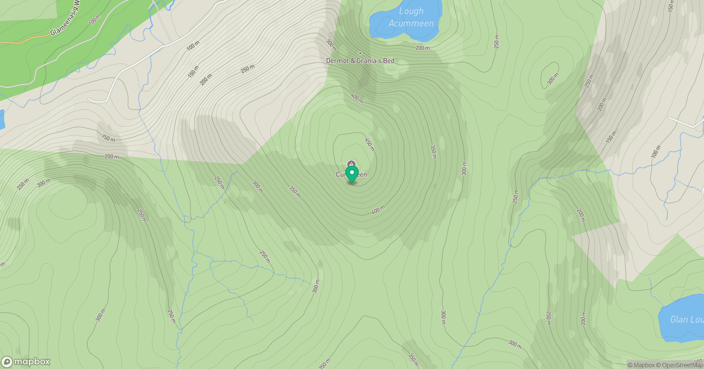
Grid reference: Q630076
View on OpenStreetMapOpens a map in a new tab, centred on the hill.
Hills within 30 km
Straight-line distance, not a walking route or confirmation of access.
No comments yet. Be the first.