
Curra Hill
Good walks are even better shared.
Overview
Curra Hill: A Hiker's Delight
Nestled in the tranquil hills of County Tyrone, Curra Hill stands proudly at 519 meters. A Marilyn in classification, it offers a perfect adventure for hikers of various skill levels, with a route that's both engaging and rewarding.
Geology
Curra Hill’s geology tells a tale of ancient volcanic history, with its granite and sandstone foundation. The remnants of glaciation add another intriguing layer, quite literally, to the landscape. It’s the kind of place where you might feel as if you’re walking on the crust of the earth!
Routes
The Brougher Mountain Circular is a popular choice, looping back to Fintona and making for a superb day out. It spans 12 kilometers, typically taking about 4.5 hours to complete. This moderate hike will leave you with ample opportunity to catch your breath (and photos) at various scenic spots.
Summit Features
At the summit, you’ll be greeted by a charming cairn, a testament to the many adventurers who have tread the same path. The views are nothing short of magnificent, rewarding your effort with a feast for the eyes.
Terrain
Prepare for a delightful mix of grassy slopes and rocky bits that beg for you to trip (just kidding, but do watch your step!). Keep an eye out for boggy areas, especially after a good rain, as they can add some unexpected challenge.
Views
The panoramic views from Curra Hill are spectacular. Gaze upon the Sperrin Mountains to the north and the serene Lough Neagh shimmering on the horizon. Spring and early summer is when the scenery really shines, with wildflowers bursting into life beneath a bright blue sky.
Hazards
As with any mountain, be mindful of the hazards. Keep an eye on the weather—Northern Ireland can be a bit temperamental. And make sure to navigate those muddy patches with care; nobody wants a slip and slide!
Nearby Summits
For those looking for a bit more adventure, consider tackling nearby Brougher Mountain, the highest in the area, or Slieve Beagh, another local favourite.
Access
Parking in Fintona is straightforward, ensuring your car is secure while you conquer the hill. Limited public transport options might make driving the most convenient choice, but hey, a little road trip never hurt anyone!
Facilities
Fintona provides all necessary amenities, from cafes to public toilets, making it easy to refuel before or after your hike.
History
The name 'Curra' translates to 'round hill' in Irish, perfectly capturing the essence of this rounded beauty. Curra Hill has been a staple in local folklore, making it not just a geographical feature, but a cultural landmark.
Conclusion
Curra Hill is a gem for those looking to escape into nature. Whether you're an experienced hiker or just enjoying a gentle jaunt, this mountain offers something for everyone. So lace up your boots, grab your camera, and don’t forget to embrace the views. Happy hiking!
Explore routes near Curra Hill
Public walks starting within 80 km of this hill. Nearby does not mean a route reaches the summit; check its map and access before setting out.
No public routes are currently listed within 80 km of Curra Hill on Walkmates. This does not mean there are no paths here. Explore the map and check local access information before planning a walk.
Route planning notes
These notes describe possible approaches, not verified navigable routes or permission to cross land. Check current paths, local access rules and conditions before setting out.
Brougher Mountain Circular
A scenic loop that starts from the village of Fintona and takes in Curra Hill, providing beautiful views of the surrounding countryside.
Make a day of it, together
Find someone to share the walk with, or organise a day out along a route you like.
Hill facts and local notes
Classifications
Elevation
275m
902 ft
Prominence
170m
Coordinates
52.0488, -9.9628
V654903
OS Map
78
At the Summit
The summit features a prominent cairn and offers a stunning 360-degree view of the rolling hills and valleys of County Tyrone.
Terrain & Geology
Curra Hill is primarily composed of granite and sandstone, indicative of ancient volcanic activity in the region. The area also features glacial deposits, which have shaped the unique topography you see today.
Views & Scenery
From the summit, hikers can enjoy views of the Sperrin Mountains to the north and the rolling hills of the surrounding countryside. On a clear day, you may even spot Lough Neagh in the distance.
History & Heritage
Name Origin
The name 'Curra' derives from the Irish 'corr', meaning a 'round hill'.
Historical Significance
The mountain is part of the ancient landscape shaping, playing a role in local folklore and cultural stories.
Getting There & Facilities
Check current local access restrictions, parking rules and transport timetables before travelling. These notes do not confirm public access to the summit.
Parking
Free parking is available in Fintona, from where you can access the route. Please park considerately.
Public Transport
Limited public transport options are available; check local bus services for availability to Fintona.
Nearby Facilities
Fintona offers several cafes and shops for refreshments, along with public toilets.
Safety Information
Known Hazards
- Watch out for sudden weather changes and be cautious of muddy or slippery sections, particularly after rain.
General Safety Tips
- Check weather conditions before setting out
- Carry appropriate clothing and equipment
- Let someone know your planned route
- Take a map, compass, and GPS device
- Carry emergency supplies: food, water, first aid kit, torch
Hills
Some common questions about the hills answered
Are there group walks up Curra Hill?
Many walkers use Walkmates to join or organise walks with others. You can check for group walks around Curra Hill through the maps
Are there other walkers around Curra Hill?
Activity varies by location and time, but Walkmates lets you see whether others have shared walks or shown interest in this area. Find other people through the walking friends search walking friends for Curra Hill search or of course create your own walk for Curra Hill
Can I organise a walk to Curra Hill?
Yes. If there aren’t any walks listed already, you can create a walk and make it available for others to join.
If you're signed up to Walkmates, you can create a walk to Curra Hill.
How do I find a walk up this hill?
There are often multiple ways to walk this hill, depending on experience and route preference. Walkmates helps you explore walks and routes that others have shared.
Can I suggest a new route up Curra Hill?
Yes. You can suggest or create routes to share with others. Walkmates focuses on the social side of walking, so routes are used to help people organise walks and explore areas together, rather than as detailed navigation tools or route libraries.
Other uses really appreciate knowledgeable walkers sharing their routes. Share your favourite route to Curra Hill here
The is an error or something incorrect about this hill. How do I let you know?
We always strive to keep the information on Walkmates as accurate as possible. If you find an error, please let us know through the contact form and we'll aim to correct it as quickly as possible
Community Discussion
Comments
Location
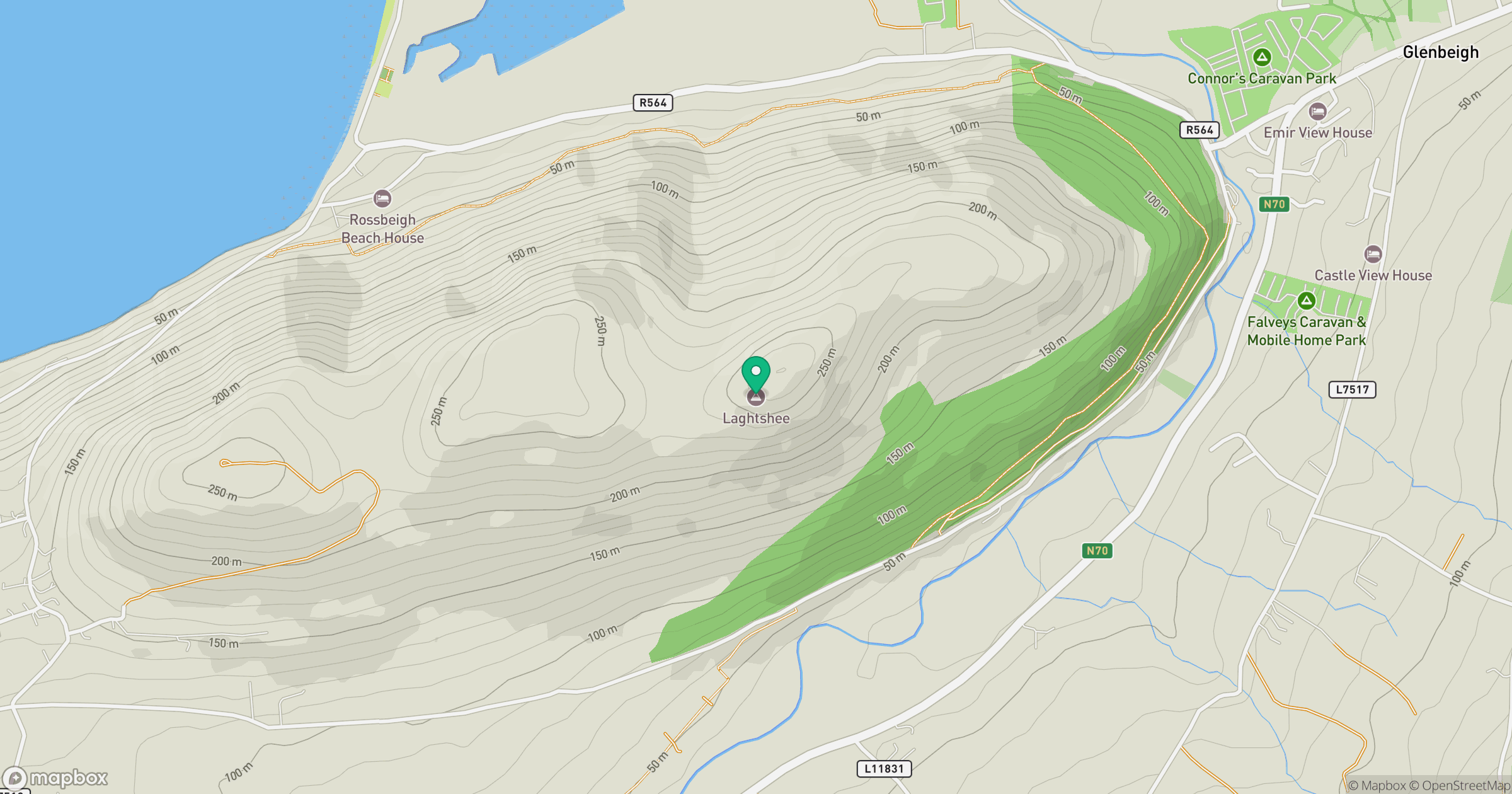
Grid reference: V654903
View on OpenStreetMapOpens a map in a new tab, centred on the hill.
Hills within 30 km
Straight-line distance, not a walking route or confirmation of access.
Caherconree
834m
Carrauntoohil
1,039m
Seefin [Sui Finn]
493m
Callahaniska
217m
Colly [An Bheann Mhor]
679m
No comments yet. Be the first.