
Crotlieve Mountain
Good walks are even better shared.
Overview
Crotlieve Mountain: A Hidden Gem in the Mournes
If you're looking for a delightful day out amidst nature, Crotlieve Mountain should be on your list. Standing at a proud 558 meters, it may not be the tallest in the Mournes, but its charm is undeniable!
Geology
Crotlieve is primarily composed of granite, with lush schist formations that create a captivating landscape. These geological features tell the story of a time when glacial activity sculpted the mountains we see today. Bring your rock hammer—or simply your sense of wonder!
Routes
The most popular route is the Crotlieve Loop, a friendly circular path that caters to most hikers. It covers about 6.5 km and takes roughly 2.5 hours. If you're feeling more ambitious, the Direct Ascent from Crotlieve Road is a shorter and steeper adventure.
Summit Features
Atop the mountain, you'll discover a granite trig point, perfect for summiting selfies or landscape photographs. This unique feature not only serves as a milestone but also as a beacon for navigators in the area.
Terrain
Expect varied terrain, with rocky outcrops, grassy slopes, and a few boggy spots—so maybe skip the flip-flops. It's not just a walk in the park, but a delightful dance with nature!
Views
The views from Crotlieve are nothing short of spectacular. Look out for the majestic Mourne Mountains, the bucolic fields of County Down, and the shimmering Carlingford Lough. Best viewed in spring and autumn, when the visibility is at its peak.
Hazards
Keep an eye on the weather; it can turn quicker than you can say 'Jack Frost'. And those rocks? They can get slippery, especially after a downpour.
Nearby Summits
Don't stop at Crotlieve! Nearby summits like Slieve Donard and Slieve Comedagh provide ample opportunity for exploration.
Access
You can find ample parking at Mourne Golf Club, just a stone's throw away from the trailhead. Newcastle offers several bus routes, making it easy for less mobile adventurers. And if you need to refuel post-hike, the town's cafes and toilets will welcome you back into the arms of modern convenience.
History
The name Crotlieve means 'the hill of the leaves’, a fitting tribute to its green surroundings. Locals and visitors alike have enjoyed this mountain for generations, making it a beloved part of the area’s culture.
In conclusion, whether you’re conquering the summit or simply strolling through its enchanting trails, Crotlieve Mountain offers a memorable experience that’s as refreshing as a cup of tea on a rainy day. Happy hiking!
Explore routes near Crotlieve Mountain
Public walks starting within 80 km of this hill. Nearby does not mean a route reaches the summit; check its map and access before setting out.
Silent Valley to Ben Crom Dam: Reservoir Road Walk, County Down
View route
Tollymore Forest Park: Mountain and Drinns Trail
View route
Tollymore Forest Park: River Trail near Newcastle
View route
Castlewellan Forest Park: Lake, Arboretum and Mitchell's Lake Circuit
View route
Route planning notes
These notes describe possible approaches, not verified navigable routes or permission to cross land. Check current paths, local access rules and conditions before setting out.
Crotlieve Loop
A popular circular route starting from the car park near the Mourne Golf Club, providing scenic views and a rewarding summit.
Direct Ascent from Crotlieve Road
A straightforward ascent following the established path directly from Crotlieve Road for those looking for a faster way to the top.
Make a day of it, together
Find someone to share the walk with, or organise a day out along a route you like.
Hill facts and local notes
Classifications
Elevation
347m
1,138 ft
Prominence
111m
Coordinates
54.1499, -6.1504
J209239
OS Map
29
At the Summit
The summit features a distinctive granite trig point, which offers an excellent photo opportunity and serves as a reliable landmark for navigators.
Terrain & Geology
Crotlieve Mountain is primarily composed of granite and lightweight schist, which gives the mountain its rolling contours and provides a unique landscape shaped by glacial activity during the last Ice Age. The rock formations reveal a fascinating history as they were formed under high pressure conditions deep within the Earth's crust.
Views & Scenery
From the summit, hikers can enjoy panoramic views of the surrounding Mourne Mountains, the lush landscapes of County Down, and on a clear day, even the coast of Carlingford Lough.
History & Heritage
Name Origin
The name Crotlieve is derived from the Irish 'Croimleabh', meaning 'the hill of the leaves', which reflects the lush vegetation found on the lower slopes.
Historical Significance
Crotlieve Mountain has been a beloved hiking destination for locals and visitors alike, making it a staple of outdoor recreation in the area.
Getting There & Facilities
Check current local access restrictions, parking rules and transport timetables before travelling. These notes do not confirm public access to the summit.
Parking
A large car park is available at the Mourne Golf Club, just a short walk to the start of the Crotlieve Loop.
Public Transport
Bus services operate from Newcastle and surrounding areas; check local timetables for details.
Nearby Facilities
Facilities in Newcastle include cafes, restaurants, and public toilets, making it a great spot to refuel before or after your hike.
Safety Information
Known Hazards
- Sudden changes in weather can pose risks. Watch out for slippery rocks, especially after rain. As with any hike in the Mournes, respect the landscape and the local wildlife.
General Safety Tips
- Check weather conditions before setting out
- Carry appropriate clothing and equipment
- Let someone know your planned route
- Take a map, compass, and GPS device
- Carry emergency supplies: food, water, first aid kit, torch
Hills
Some common questions about the hills answered
Are there group walks up Crotlieve Mountain?
Many walkers use Walkmates to join or organise walks with others. You can check for group walks around Crotlieve Mountain through the maps
Are there other walkers around Crotlieve Mountain?
Activity varies by location and time, but Walkmates lets you see whether others have shared walks or shown interest in this area. Find other people through the walking friends search walking friends for Crotlieve Mountain search or of course create your own walk for Crotlieve Mountain
Can I organise a walk to Crotlieve Mountain?
Yes. If there aren’t any walks listed already, you can create a walk and make it available for others to join.
If you're signed up to Walkmates, you can create a walk to Crotlieve Mountain.
How do I find a walk up this hill?
There are often multiple ways to walk this hill, depending on experience and route preference. Walkmates helps you explore walks and routes that others have shared.
Can I suggest a new route up Crotlieve Mountain?
Yes. You can suggest or create routes to share with others. Walkmates focuses on the social side of walking, so routes are used to help people organise walks and explore areas together, rather than as detailed navigation tools or route libraries.
Other uses really appreciate knowledgeable walkers sharing their routes. Share your favourite route to Crotlieve Mountain here
The is an error or something incorrect about this hill. How do I let you know?
We always strive to keep the information on Walkmates as accurate as possible. If you find an error, please let us know through the contact form and we'll aim to correct it as quickly as possible
Community Discussion
Comments
Location
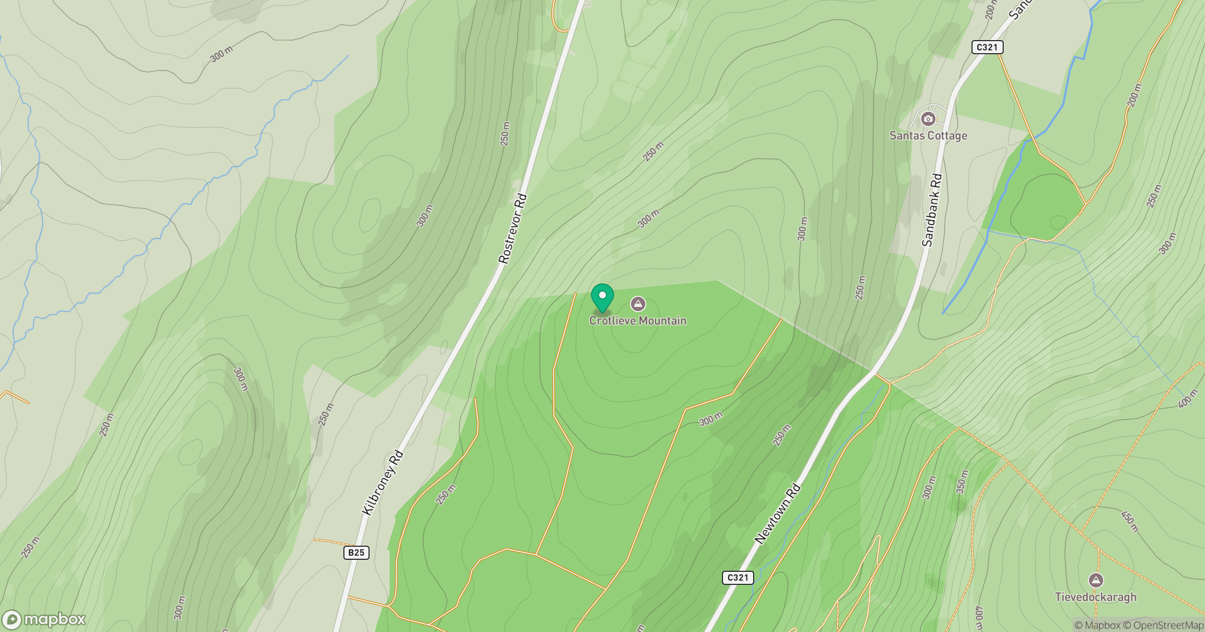
Grid reference: J209239
View on OpenStreetMapOpens a map in a new tab, centred on the hill.
Hills within 30 km
Straight-line distance, not a walking route or confirmation of access.
No comments yet. Be the first.