

Crib Goch
Good walks are even better shared.
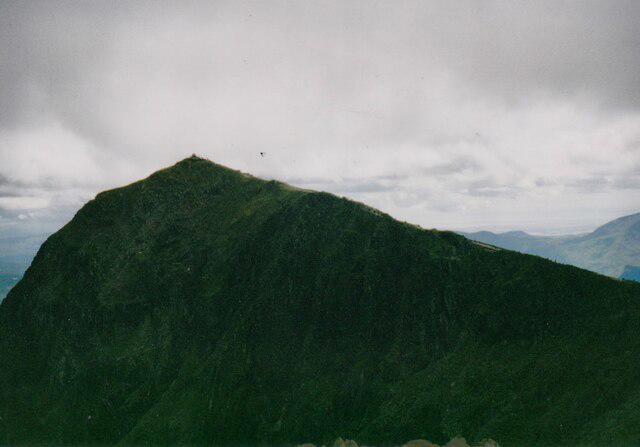
SH6255 : Crib Goch from the Pyg Track
Eirian Evans Photo source
Overview
Crib Goch is a 923.9 m summit and knife-edge ridge in the Yr Wyddfa (Snowdon) massif, Eryri. Its usual East Ridge approach and traverse are exposed Grade 1 scrambling requiring hands, feet, confident route-finding and previous scrambling experience. It is unsuitable for inexperienced walkers or wet and windy conditions.
Crib Goch
Crib Goch is a 923.9 m summit and narrow ridge in the Yr Wyddfa (Snowdon) massif in Eryri. Its name means “red ridge”. The usual East Ridge ascent and ridge traverse are Grade 1 scrambles with serious exposure. They require previous scrambling experience, confident route-finding and the use of hands as well as feet.
Routes and returns
The usual approach starts at Pen y Pass on the Pyg Track and leaves it at Bwlch y Moch for the East Ridge. The traverse continues over the ridge and pinnacles to Bwlch Coch, then over Crib y Ddysgl to Garnedd Ugain and via Bwlch Glas to Yr Wyddfa. For a circuit back to Pen y Pass, return to Bwlch Glas and descend the Pyg Track. The Llanberis Path leads to Llanberis, so it is not a return to the same starting point.
The longer Snowdon Horseshoe adds Y Lliwedd. From Yr Wyddfa, descend the upper southwest ridge to the Watkin Path junction, then follow the Watkin route via Bwlch y Saethau to Bwlch Ciliau before continuing over Y Lliwedd and Lliwedd Bach. Descend to Llyn Llydaw and follow the Miners’ Track back to Pen y Pass. This complete circuit is about 12 km and includes further exposed scrambling. The Miners’ Track is a return leg here, not a direct East Ridge ascent.
These are route summaries, not turn-by-turn navigation instructions. Use a suitable map and a detailed scrambling guide, and plan the full descent.
Terrain and safety
The narrow crest, steep drops, pinnacles and slippery or loose rock demand sustained care. There is no straightforward escape from the committed ridge. A Grade 1 rating does not make this a low-risk walk. Eryri advises against attempting it in wet or windy weather, and says dogs must not be taken. If your experience or conditions are unsuitable, choose another route before committing.
Snow and ice make this a winter mountaineering undertaking requiring appropriate equipment and ice-axe and crampon skills. Check the mountain forecast and ground conditions. In a mountain emergency, call 999 or 112 and ask for Police, then Mountain Rescue.
Summit, geology and views
The summit is a rocky high point. The high ridge is intrusive rhyolite within the Ordovician volcanic succession. In clear weather there are views towards Garnedd Ugain and Yr Wyddfa; cloud can quickly obscure the surrounding mountains.
Access and facilities
Pen y Pass parking uses seasonal advance booking; check current arrangements before travelling. Sherpa’r Wyddfa buses provide an alternative from Llanberis and Nant Peris. Check the last return service in advance. Public toilets are listed at Pen y Pass Warden Centre; carry enough food and water for the day.
Cultural history
Crib Goch features in T. Rowland Hughes’s 1948 poem of the same name and in paintings by Kyffin Williams.
Explore routes near Crib Goch
Walks starting near this hill. Open a route to check its map, distance and full itinerary.
Snowdon Pyg Track returning by Miner's Track
View route
Beddgelert Forest: Derwen Circuit and Llyn Llywelyn
View route
Beddgelert Forest: Llyn Llywelyn Woodland Circuit
View route
Llyn Crafnant: Lakeside Circuit from the NRW Car Park
View route
Route planning notes
These notes describe possible approaches. Check a route's map and access information when planning your walk.
Crib Goch East Ridge and Yr Wyddfa, returning by the Pyg Track
From Pen y Pass, use the Pyg Track approach to Bwlch y Moch, then the East Ridge scramble. Traverse Crib Goch and its pinnacles to Bwlch Coch, continue over Crib y Ddysgl to Garnedd Ugain, then via Bwlch Glas to Yr Wyddfa. Return to Bwlch Glas and descend the Pyg Track to Pen y Pass. Serious exposure and route-finding throughout the scrambles; this outline is not a navigation guide.
Snowdon Horseshoe via Crib Goch and Y Lliwedd
From Pen y Pass, follow the Pyg approach, Crib Goch East Ridge and traverse, Crib y Ddysgl, Garnedd Ugain and Bwlch Glas to Yr Wyddfa. Descend the upper southwest ridge to the Watkin Path junction, then via Bwlch y Saethau and Bwlch Ciliau to Y Lliwedd. Cross its summits and Lliwedd Bach, descend to Llyn Llydaw and return on the Miners’ Track to Pen y Pass. About 12 km; sustained exposed scrambling and careful navigation.
Make a day of it, together
Find someone to share the walk with, or organise a day out along a route you like.
Photo Gallery
View all Photo could not load
SH6255 : Crib Goch from the Pyg Track
Eirian Evans
 Photo could not load
SH6255 : Heading along Crib Goch's ridge
Gareth James
 Photo could not load
SH6255 : Crib Goch
Eirian Evans
 Photo could not load
SH6255 : Walkers on Grib Goch
Eric Jones
 Photo could not load
SH6255 : Approaching the pinnacles of Grib Goch
Julian Paren
 Photo could not load
SH6255 : Along the Crib Goch ridge
Trevor Littlewood
 Photo could not load
SH6255 : Crib Goch from Watkin Path
Stephen MARSDEN
 Photo could not load
SH6255 : Look back along the Crib Goch ridge
Peter S
 Photo could not load
SH6255 : Christmas Day 2010: The evening sun catching Crib Goch
David Medcalf

SH6255 : Look back at Crib Goch
Peter S
Hill facts and local notes
Classifications
Elevation
924m
3,031 ft
Prominence
67m
Coordinates
53.0761, -4.0552
SH624551
OS Map
115
Explorer: OL17W
At the Summit
Rocky high point on the narrow ridge.
Terrain & Geology
The high ridge and summit are formed of intrusive rhyolite within the Ordovician volcanic succession of the Snowdon massif. British Geological Survey describes the rhyolite intruding the Bedded Pyroclastic Formation above the Lower Rhyolitic Tuff Formation.
Views & Scenery
In clear weather, views along the ridge include Garnedd Ugain and Yr Wyddfa (Snowdon), with the surrounding Eryri mountains. Low cloud can obscure the views and make route-finding harder.
History & Heritage
Name Origin
Crib Goch means “red ridge” in Welsh.
Historical Significance
Crib Goch appears in Welsh art and literature, including T. Rowland Hughes’s 1948 poem “Crib Goch” and paintings by Kyffin Williams, documented in Cadw’s artistic-heritage interpretation plan.
Getting There & Facilities
Parking
Pen y Pass is the usual starting point for the East Ridge approach. Parking is limited and uses seasonal advance booking: check Eryri’s current arrangements and book when required. Arriving early does not replace a booking. Nant Peris park-and-ride with the Sherpa’r Wyddfa bus is an alternative.
Public Transport
Sherpa’r Wyddfa buses link Llanberis and Nant Peris with Pen y Pass; connecting services also serve other Eryri towns. Check the current timetable, seasonal service and last return before setting out.
Nearby Facilities
Public toilets are listed at Pen y Pass Warden Centre. Check refreshment opening times before travelling and carry sufficient food and water for the whole route.
Safety Information
Known Hazards
- Severe exposure and steep drops: a slip can be fatal. Grade 1 describes technical difficulty, not low risk.
- The ridge and pinnacles require hands-on scrambling and careful route-finding; there is no straightforward escape once committed to the ridge.
- Loose or polished rock can be slippery, especially when damp; wind can make balance precarious.
- Unsuitable for inexperienced walkers and for wet or windy conditions. Eryri advises that dogs must not be taken.
Seasonal Hazards
Snow and ice turn Crib Goch into a winter mountaineering route requiring appropriate experience, ice-axe and crampon skills and equipment. Wet rock, strong wind and poor visibility can make it hazardous in any season. Check mountain weather and ground conditions before committing.
General Safety Tips
- Check weather conditions before setting out
- Carry appropriate clothing and equipment
- Let someone know your planned route
- Take a map, compass, and GPS device
- Carry emergency supplies: food, water, first aid kit, torch
Hills
Some common questions about the hills answered
Are there group walks up Crib Goch?
Many walkers use Walkmates to join or organise walks with others. You can check for group walks around Crib Goch through the maps
Are there other walkers around Crib Goch?
Activity varies by location and time, but Walkmates lets you see whether others have shared walks or shown interest in this area. Find other people through the walking friends search walking friends for Crib Goch search or of course create your own walk for Crib Goch
Can I organise a walk to Crib Goch?
Yes. If there aren’t any walks listed already, you can create a walk and make it available for others to join.
If you're signed up to Walkmates, you can create a walk to Crib Goch.
How do I find a walk up this hill?
There are often multiple ways to walk this hill, depending on experience and route preference. Walkmates helps you explore walks and routes that others have shared.
Can I suggest a new route up Crib Goch?
Yes. You can suggest or create routes to share with others. Walkmates focuses on the social side of walking, so routes are used to help people organise walks and explore areas together, rather than as detailed navigation tools or route libraries.
Other uses really appreciate knowledgeable walkers sharing their routes. Share your favourite route to Crib Goch here
The is an error or something incorrect about this hill. How do I let you know?
We always strive to keep the information on Walkmates as accurate as possible. If you find an error, please let us know through the contact form and we'll aim to correct it as quickly as possible
Community Discussion
Comments
Location
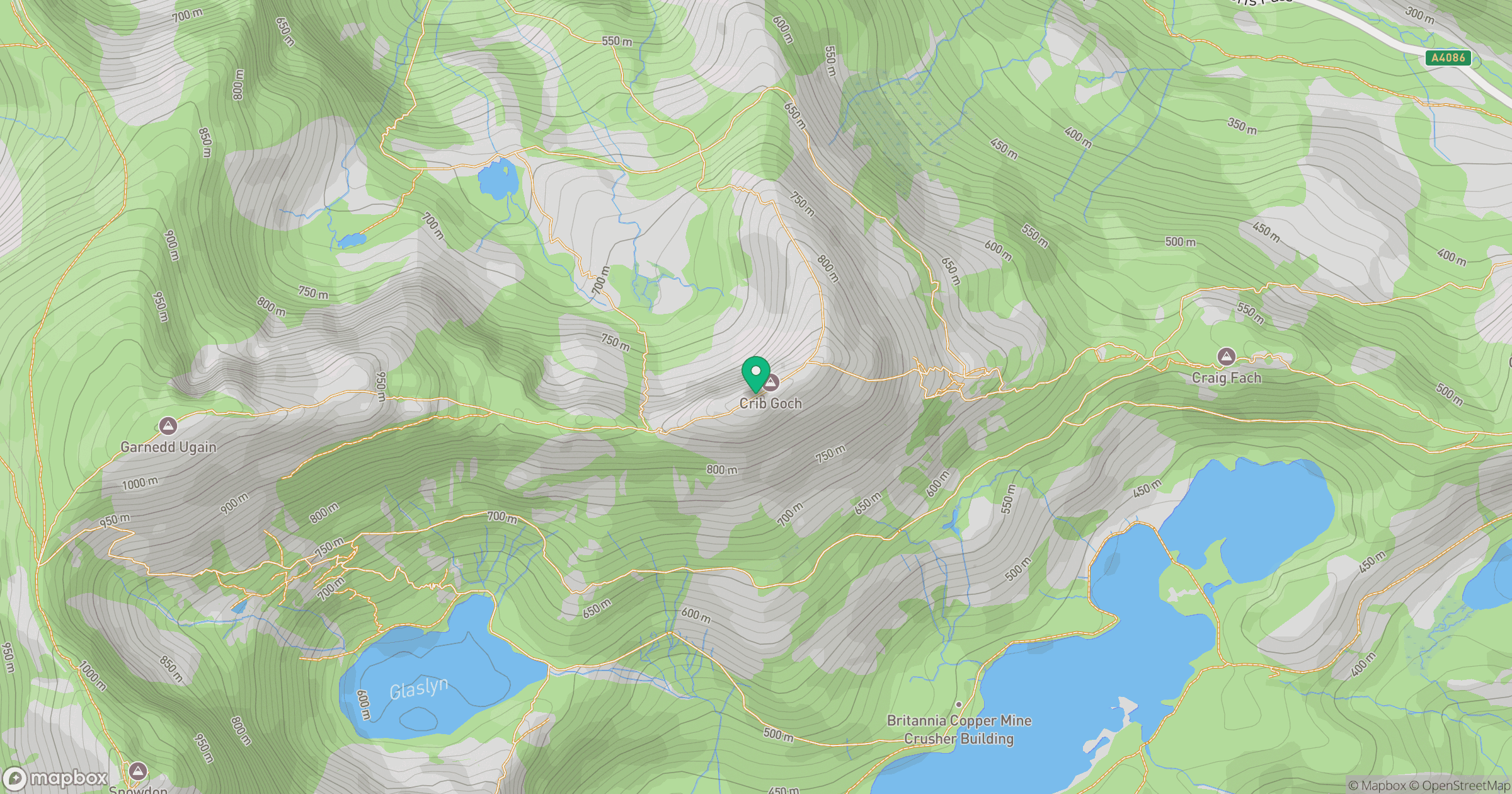
Grid reference: SH624551
View on OpenStreetMapOpens a map in a new tab, centred on the hill.
No comments yet. Be the first.