

Carnedd Dafydd
Good walks are even better shared.
SH6662 : Approaching the summit of Carnedd Dafydd
Jeremy Bolwell Photo source
Overview
Carnedd Dafydd
Carnedd Dafydd rises to 1,044.5 m (3,427 ft) in the Carneddau of Eryri (Snowdonia). Its rocky summit is linked by high ridges to Pen yr Ole Wen and Carnedd Llewelyn. The summit has a cairn and stone shelters; the former Ordnance Survey triangulation pillar is recorded as destroyed.
Routes
These are planning summaries, not turn-by-turn directions. Choose a complete route on a suitable map and work out distance, ascent and timing from your actual starting point. All five options are strenuous mountain outings; some include scrambling.
1. Carnedd Dafydd via Pen yr Ole Wen Circular
From Ogwen Cottage, climb the steep south spur of Pen yr Ole Wen, then follow the ridge past Carnedd Fach to Carnedd Dafydd. Retrace the ridge to Pen yr Ole Wen before descending its east ridge, with a short scramble, to Afon Lloer and Tal y Llyn. Return beside Llyn Ogwen. This strenuous mountain circuit needs confident navigation.
2. Carnedd Dafydd and Carnedd Llewelyn Ridge Walk
From the eastern end of Llyn Ogwen, follow Afon Lloer and scramble onto Pen yr Ole Wen. Continue over Carnedd Dafydd and Cefn Ysgolion Duon to Carnedd Llewelyn. Descend towards Bwlch Eryl Farchog, then south to Ffynnon Llugwy and the valley paths. This long circuit includes steep ground and scrambling; plan the return to your exact start.
3. Carnedd Dafydd via Afon Lloer and Pen yr Ole Wen
Approach Cwm Lloer from the eastern end of Llyn Ogwen beside Afon Lloer. Take the established east-ridge route, including a short scramble, to Pen yr Ole Wen, then continue past Carnedd Fach to Carnedd Dafydd. Return by the same route. Wet ground, stream crossings and steep rock require care; this is a strenuous mountain outing.
4. Carnedd Dafydd from Gerlan via Mynydd Du
From Gerlan above Bethesda, use the Cwm Llafar approach to reach Mynydd Du and ascend towards Foel Meirch and Carnedd Dafydd. The upper climb is steep and rocky, with rough or indistinct sections. Return by the same route. Strong navigation is essential, especially in mist, and village parking must not obstruct residents or access.
5. Carnedd Dafydd, Carnedd Llewelyn and Yr Elen from Gerlan
A demanding circuit from Gerlan: ascend via Mynydd Du and Foel Meirch to Carnedd Dafydd, follow Cefn Ysgolion Duon to Carnedd Llewelyn, then cross to Yr Elen. Descend towards Cwm Caseg and return to Gerlan. Expect a long mountain day with steep rock and pathless ground; plan the full route on a map and allow for difficult navigation.
Terrain, views and safety
Expect rocky ridges, boulders, scree, grassy slopes and wet ground on some approaches. In clear weather, the views include the Glyderau, Tryfan, Yr Wyddfa and Carnedd Llewelyn. Visibility and weather, rather than a particular season, determine what can be seen.
The northern cliffs and the edges beside Cefn Ysgolion Duon demand care. Mist can make navigation difficult even on broad summit ground. Check a mountain forecast, carry a map and compass and know how to use them. Bring suitable footwear, warm and waterproof layers, food, water and a torch. Snow or ice requires winter mountaineering equipment and skills. Turn back if conditions exceed the group’s abilities. In a mountain emergency, call 999 and ask for Police, then Mountain Rescue.
Geology
The Carneddau have an Ordovician volcanic and sedimentary setting. BGS places the type area of the Llewelyn Volcanic Group between Carnedd Dafydd and Conwy Mountain. This group includes ash-flow tuffs and other volcanic rocks. Glaciation later shaped the surrounding Ogwen landscape.
Access and facilities
The small Ogwen Centre car park near Ogwen Cottage is at the western end of Llyn Ogwen. Parking is limited; use lawful spaces and observe A5 restrictions. Gerlan is a separate starting point for the western approaches, where parking must not obstruct residents or access.
The T10 links Bangor, Bethesda, Ogwen and Betws-y-Coed. Check the current timetable and last return service. The Ogwen Centre provides toilets and a snack bar, but carry everything needed for the mountain day and check refreshment opening arrangements.
Name and history
Carnedd Dafydd means Dafydd’s cairn, or David’s cairn. Traditions connect the name with a medieval Welsh prince, but sources differ over whether this was Dafydd ap Llywelyn or Dafydd ap Gruffydd. Coflein records the summit cairn as a probable Bronze Age burial monument, much older than either prince. Its stones should be left undisturbed.
Nearby summits
Carnedd Llewelyn (1,061.8 m) and Pen yr Ole Wen (978.5 m) are connected by the main ridge system. Elevations follow DoBIH v18.6; older guides often give different figures.
Explore routes near Carnedd Dafydd
Walks starting near this hill. Open a route to check its map, distance and full itinerary.
Snowdon Pyg Track returning by Miner's Track
View route
Llyn Crafnant: Lakeside Circuit from the NRW Car Park
View route
Beddgelert Forest: Derwen Circuit and Llyn Llywelyn
View route
Beddgelert Forest: Llyn Llywelyn Woodland Circuit
View route
Route planning notes
These notes describe possible approaches. Check a route's map and access information when planning your walk.
Carnedd Dafydd via Pen yr Ole Wen Circular
From Ogwen Cottage, climb the steep south spur of Pen yr Ole Wen, then follow the ridge past Carnedd Fach to Carnedd Dafydd. Retrace the ridge to Pen yr Ole Wen before descending its east ridge, with a short scramble, to Afon Lloer and Tal y Llyn. Return beside Llyn Ogwen. This strenuous mountain circuit needs confident navigation.
Carnedd Dafydd and Carnedd Llewelyn Ridge Walk
From the eastern end of Llyn Ogwen, follow Afon Lloer and scramble onto Pen yr Ole Wen. Continue over Carnedd Dafydd and Cefn Ysgolion Duon to Carnedd Llewelyn. Descend towards Bwlch Eryl Farchog, then south to Ffynnon Llugwy and the valley paths. This long circuit includes steep ground and scrambling; plan the return to your exact start.
Carnedd Dafydd via Afon Lloer and Pen yr Ole Wen
Approach Cwm Lloer from the eastern end of Llyn Ogwen beside Afon Lloer. Take the established east-ridge route, including a short scramble, to Pen yr Ole Wen, then continue past Carnedd Fach to Carnedd Dafydd. Return by the same route. Wet ground, stream crossings and steep rock require care; this is a strenuous mountain outing.
Carnedd Dafydd from Gerlan via Mynydd Du
From Gerlan above Bethesda, use the Cwm Llafar approach to reach Mynydd Du and ascend towards Foel Meirch and Carnedd Dafydd. The upper climb is steep and rocky, with rough or indistinct sections. Return by the same route. Strong navigation is essential, especially in mist, and village parking must not obstruct residents or access.
Carnedd Dafydd, Carnedd Llewelyn and Yr Elen from Gerlan
A demanding circuit from Gerlan: ascend via Mynydd Du and Foel Meirch to Carnedd Dafydd, follow Cefn Ysgolion Duon to Carnedd Llewelyn, then cross to Yr Elen. Descend towards Cwm Caseg and return to Gerlan. Expect a long mountain day with steep rock and pathless ground; plan the full route on a map and allow for difficult navigation.
Make a day of it, together
Find someone to share the walk with, or organise a day out along a route you like.
Photo Gallery
View all Photo could not load
SH6662 : Approaching the summit of Carnedd Dafydd
Jeremy Bolwell
 Photo could not load
SH6662 : Cairn near the summit of Carnedd Dafydd
Philip Halling
 Photo could not load
SH6662 : Approach to the summit of Carnedd Dafydd
Kenneth Yarham
 Photo could not load
SH6662 : The path towards Carnedd Dafydd from Pen Yr Ole Wen
Jeremy Bolwell
 Photo could not load
SH6662 : Carnedd Dafydd from Pen Yr Ole Wen
Jeremy Bolwell
 Photo could not load
SH6663 : Carnedd Dafydd - the shelter and the summit cairn
Ian Greig
 Photo could not load
SH6663 : Carnedd Dafydd from the south western slopes of Carnedd Llewelyn
Colin Park
 Photo could not load
SH6662 : View of Carnedd Dafydd from Pen yr Ole Wen
Chris Andrews
 Photo could not load
SH6662 : Shelter cairn near the summit of Carnedd Dafydd
Jeremy Bolwell

SH6663 : Carnedd Dafydd
Chris Andrews
Hill facts and local notes
Classifications
Elevation
1,044m
3,427 ft
Prominence
115m
Coordinates
53.1477, -4.0008
SH662630
OS Map
115
Explorer: OL17W
At the Summit
A summit cairn and stone shelters. The former Ordnance Survey triangulation pillar is recorded as destroyed.
Terrain & Geology
The Carneddau contain Ordovician volcanic and sedimentary rocks. BGS places the type area of the Llewelyn Volcanic Group between Carnedd Dafydd and Conwy Mountain; the group includes acidic ash-flow tuffs and other volcanic rocks. Later glaciation shaped the surrounding Ogwen landscape.
Views & Scenery
In clear weather, views extend across the Glyderau and Tryfan towards Yr Wyddfa (Snowdon), with Carnedd Llewelyn nearby and Anglesey to the north-west.
History & Heritage
Name Origin
Dafydd’s cairn (David’s cairn). The name is traditionally linked with a medieval Welsh prince, but sources differ between Dafydd ap Llywelyn and Dafydd ap Gruffydd; the identity should not be stated as certain.
Historical Significance
Coflein records a probable Bronze Age burial cairn on the summit, later disturbed by stone shelters and an Ordnance Survey triangulation pillar, now destroyed. The archaeological cairn predates the medieval princes associated with the mountain’s name. Leave the cairn and its stones undisturbed.
Getting There & Facilities
Parking
For Ogwen approaches, use the small Ogwen Centre car park near Ogwen Cottage at the western end of Llyn Ogwen, or other lawful parking appropriate to your route. Spaces are limited and A5 restrictions apply. Gerlan approaches have a different starting point; avoid obstructing residents, gates or emergency access.
Public Transport
The TrawsCymru T10 links Bangor, Bethesda and Betws-y-Coed and stops at Ogwen. Check the current timetable and your last return service before travelling: https://eryri.gov.wales/visit/ogwen/
Nearby Facilities
The Ogwen Centre has public toilets and a snack bar serving drinks and food. These facilities are in the valley, so carry sufficient food, water and mountain equipment for the whole route; check current opening arrangements before relying on refreshments.
Safety Information
Known Hazards
- Steep crags and drops, particularly beside the northern cliffs and Cefn Ysgolion Duon
- Loose stones, boulders and scree; short scrambling sections on some approaches
- Difficult navigation on broad summit ground and indistinct paths in mist
- Strong winds, rapid weather changes, wet ground and stream crossings
Seasonal Hazards
Snow and ice can turn these routes into serious winter mountaineering. Suitable winter equipment and the skills to use it are essential. Check mountain forecasts, allow for short daylight hours and turn back if conditions exceed the group’s abilities.
General Safety Tips
- Check weather conditions before setting out
- Carry appropriate clothing and equipment
- Let someone know your planned route
- Take a map, compass, and GPS device
- Carry emergency supplies: food, water, first aid kit, torch
Hills
Some common questions about the hills answered
Are there group walks up Carnedd Dafydd?
Many walkers use Walkmates to join or organise walks with others. You can check for group walks around Carnedd Dafydd through the maps
Are there other walkers around Carnedd Dafydd?
Activity varies by location and time, but Walkmates lets you see whether others have shared walks or shown interest in this area. Find other people through the walking friends search walking friends for Carnedd Dafydd search or of course create your own walk for Carnedd Dafydd
Can I organise a walk to Carnedd Dafydd?
Yes. If there aren’t any walks listed already, you can create a walk and make it available for others to join.
If you're signed up to Walkmates, you can create a walk to Carnedd Dafydd.
How do I find a walk up this hill?
There are often multiple ways to walk this hill, depending on experience and route preference. Walkmates helps you explore walks and routes that others have shared.
Can I suggest a new route up Carnedd Dafydd?
Yes. You can suggest or create routes to share with others. Walkmates focuses on the social side of walking, so routes are used to help people organise walks and explore areas together, rather than as detailed navigation tools or route libraries.
Other uses really appreciate knowledgeable walkers sharing their routes. Share your favourite route to Carnedd Dafydd here
The is an error or something incorrect about this hill. How do I let you know?
We always strive to keep the information on Walkmates as accurate as possible. If you find an error, please let us know through the contact form and we'll aim to correct it as quickly as possible
Community Discussion
Comments
Location
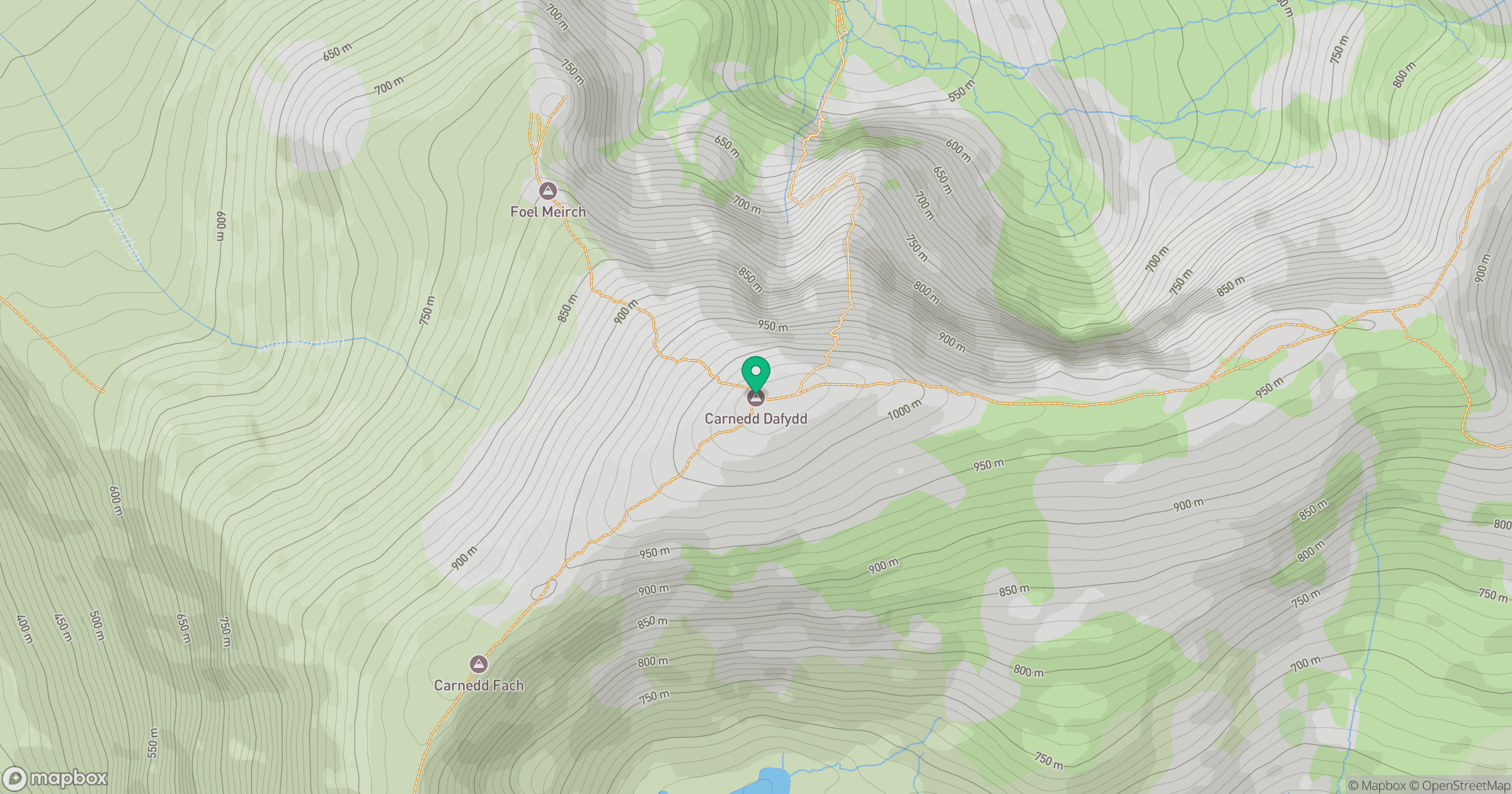
Grid reference: SH662630
View on OpenStreetMapOpens a map in a new tab, centred on the hill.
No comments yet. Be the first.