

Creag a' Chalamain
Good walks are even better shared.
NH9605 : Loch Morlich from Creag a' Chalamain
John G Burns Photo source
Overview
Creag a' Chalamain: The Mountain of the Calm Spirit
Introduction
Nestled in the breathtaking Scottish Highlands, Creag a' Chalamain stands proudly at 1037 meters. Known for its rugged charm and splendid views, this Munro is a favourite for seasoned hikers and those looking to dip their toes into the world of mountain climbing.
Geology
Creag a' Chalamain is fashioned from Grampian granite, that tough Scottish rock which has been shaped by glaciers and time. The jagged outcrops offer not just a challenge, but also a glimpse into the past—evidence of glacial activity can be spotted along the way, reminding us of the sheer power of nature.
Route Details
The most popular route begins from the Abernethy Forest car park. This 8 km trek takes you through dense forests before breaking out into open moorland. Tread carefully over rocky passages and remember that the summit is rewarding, but getting there can be spirited work!
Summit Features
Upon reaching the summit, don’t miss the sizable cairn that marks the top—perfect for a photo opportunity and a much-needed breather. The panoramic views from here are simply marvellous, from the rolling hills to the sparkling lakes.
Terrain
Expect a mix of terrain from grassy expanses to rocky outcrops. Watch out for the muddy patches that test your sturdy boots and balance! Don’t forget to appreciate the unique flora that adds colour to the landscape.
Views
Once you reach the top, prepare to be spellbound. On a clear day, the stunning panoramas of the Cairngorms, Loch Morlich, and beyond are nothing short of spectacular. Each season offers a different perspective—spring brings vibrant greenery, while autumn delivers a riot of colours.
Precautions
As with all mountains, Creag a’ Chalamain comes with its own set of hazards. Be prepared for sudden weather changes—one moment you might bask in sunshine, the next you're drenched! Keep a watchful eye on the ground to avoid falls on the rocky bits and those sneaky muddy patches.
Conclusion
Creag a' Chalamain is not just a mountain; it’s an experience. Grab your gear, lace up those boots, and make the journey. Who knows, you might encounter the calm spirit watching over the land!
Happy hiking!
Explore routes near Creag a' Chalamain
Walks starting near this hill. Open a route to check its map, distance and full itinerary.
Rothiemurchus: Beaver Trail and Lochan Mor
View route
Aviemore: Loch an Eilein and the Croft Track from Rothiemurchus
View route
Cairngorms night walk and stargazing (event meeting)
View route
Cairngorms night walk and stargazing (event meeting)
View route
Route planning notes
These notes describe possible approaches. Check a route's map and access information when planning your walk.
Chalamain Gap Approach
A scenic and relatively straightforward route starting from the Abernethy Forest car park, this approach takes you through lush woodlands before leading up to the open moorland that hugs the flanks of the mountain.
Make a day of it, together
Find someone to share the walk with, or organise a day out along a route you like.
Photo Gallery
View all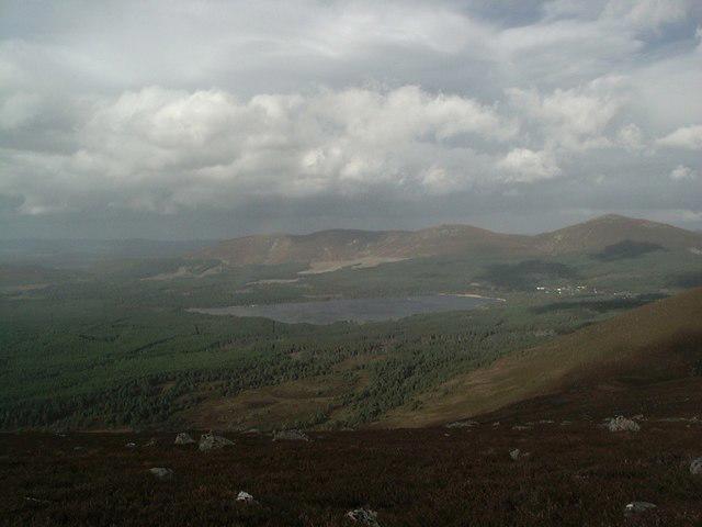 Photo could not load
NH9605 : Loch Morlich from Creag a' Chalamain
John G Burns
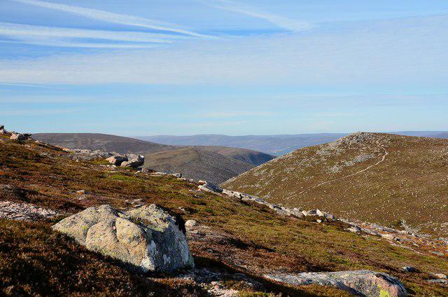 Photo could not load
NH9605 : Creag a' Chalamain
Jim Barton
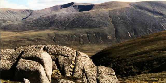 Photo could not load
NH9605 : Summit rocks, Creag a'Chalamain
John S Ross
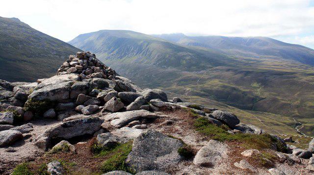 Photo could not load
NH9605 : Creag a' Chalamain summit
Colin Kinnear
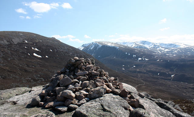 Photo could not load
NH9605 : Cairn, Creag a' Chalamain
Dorothy Carse
Hill facts and local notes
Classifications
Elevation
786m
2,580 ft
Prominence
88m
Coordinates
57.1269, -3.7166
NH961053
OS Map
36
Explorer: OL57S 403S
At the Summit
The summit features a prominent cairn which many often use as a backdrop for photos, providing a perfect excuse to catch your breath and marvel at the spectacular views.
Terrain & Geology
Creag a' Chalamain is primarily composed of Grampian granite, a resilient rock that has withstood the test of time and weather. The rugged terrain is dotted with interesting glacial features that tell tales of the last Ice Age.
Views & Scenery
From the summit, you can enjoy breathtaking views of the Cairngorms, Loch Morlich, and the expansive Abernethy Forest. On a clear day, you might even spot the North Sea glimmering far in the distance.
History & Heritage
Name Origin
Creag a' Chalamain translates to 'rock of the calm one' in Gaelic. Legend has it that a gentle spirit watches over the hikers here—though don’t expect to see her; she’s very shy.
Historical Significance
The mountain has been a part of Scottish folklore and is often featured in local tales, making it a cultural gem as well as a physical challenge.
Getting There & Facilities
Parking
The closest parking is at the Abernethy Forest car park (NH 981 128), which provides ample space and is just a short stroll from the starting point of your hike.
Public Transport
Public transport is limited in this region. The nearest bus service operates from Aviemore, but you’ll need to check schedules as they’re infrequent; car or bike is advised for the adventurous.
Nearby Facilities
In Aviemore, you’ll find cafes, shops, and facilities such as public toilets. It’s wise to sort your snacks before you venture into the wilderness!
Safety Information
Known Hazards
- Changing weather conditions can turn a pleasant hike into an epic battle with the elements, so don't forget your waterproofs! Rocky terrain means watch your ankles, and those boggy patches are excellent at testing your balance.
General Safety Tips
- Check weather conditions before setting out
- Carry appropriate clothing and equipment
- Let someone know your planned route
- Take a map, compass, and GPS device
- Carry emergency supplies: food, water, first aid kit, torch
Hills
Some common questions about the hills answered
Are there group walks up Creag a' Chalamain?
Many walkers use Walkmates to join or organise walks with others. You can check for group walks around Creag a' Chalamain through the maps
Are there other walkers around Creag a' Chalamain?
Activity varies by location and time, but Walkmates lets you see whether others have shared walks or shown interest in this area. Find other people through the walking friends search walking friends for Creag a' Chalamain search or of course create your own walk for Creag a' Chalamain
Can I organise a walk to Creag a' Chalamain?
Yes. If there aren’t any walks listed already, you can create a walk and make it available for others to join.
If you're signed up to Walkmates, you can create a walk to Creag a' Chalamain.
How do I find a walk up this hill?
There are often multiple ways to walk this hill, depending on experience and route preference. Walkmates helps you explore walks and routes that others have shared.
Can I suggest a new route up Creag a' Chalamain?
Yes. You can suggest or create routes to share with others. Walkmates focuses on the social side of walking, so routes are used to help people organise walks and explore areas together, rather than as detailed navigation tools or route libraries.
Other uses really appreciate knowledgeable walkers sharing their routes. Share your favourite route to Creag a' Chalamain here
The is an error or something incorrect about this hill. How do I let you know?
We always strive to keep the information on Walkmates as accurate as possible. If you find an error, please let us know through the contact form and we'll aim to correct it as quickly as possible
Community Discussion
Comments
Location
View the hill's mapped position and surrounding paths.
Grid reference: NH961053
View on OpenStreetMapOpens a map in a new tab, centred on the hill.
![Ben Macdui [Beinn Macduibh]](https://cdn.walkmates.com/gallery-images/e60cf32aeb394c3282fcdd14a63368f0.jpg)
No comments yet. Be the first.