

Carn Faire nan Con
Good walks are even better shared.
Overview
Carn Faire nan Con
Situated in the picturesque Scottish Highlands, Carn Faire nan Con stands tall at 672 meters, with an admirable prominence that attracts hikers across the region. The mountain is a Marilyn, making it a cherished challenge for outdoor enthusiasts who seek a rewarding summit experience.
Geology
Primarily composed of granite, Carn Faire nan Con represents the rugged beauty typifying this part of Scotland. The geological features include glacial remnants and scattered schist, offering a fascinating glimpse into the Earth's history that shaped the landscape.
Route Details
One of the most popular routes is the Glen Shiel Path, which starts at the southern banks and meanders through lush, grassy slopes, promising an exhilarating journey. It spans approximately 7.5 km and typically takes around 3.5 hours to navigate, rated as moderate in difficulty—ideal for both keen beginners and seasoned hikers looking for a scenic excursion.
Summit Features
The summit boasts a respectable stone cairn - the hallmark of summiting which you've absolutely earned! Take in the breathtaking views, with Loch Duich glistening below and the stunning Five Sisters of Kintail forming a majestic backdrop. It’s a sight that’ll make all that uphill effort worth it.
Terrain
Expect a blend of grassy trails giving way to rocky outcrops as you charge toward the summit. The path may greet you with heather-drenched hillsides, especially delightful in the warmer months.
Views
Prepare your breath-taking snapshot, because the summit offers views to remember. You’ll see the shimmering waters of Loch Duich and, if luck smiles upon you, the Isle of Skye stretches into the horizon, a reminder that beauty truly surrounds us. Late spring and early autumn are the ideal times for these stunning vistas, where the scenery is vibrant and crisp.
Hazards
Keep your wits about you! The weather can change faster than you can say 'bring a jacket’, so be prepared for high winds and unexpected downpours. Some sections can be boggy, so sturdy footwear is a must to keep those tootsies dry.
Nearby Summits
Hiking is all about exploration! Nearby lies Sgurr a' Mhaoraich at 941 meters and Saileag at 861 meters, perfect for adventurous souls looking to extend their journey.
Access
Parking
Nearest parking is available at the end of the A87, ideally situated near the Glen Shiel trailhead. It’s a small, yet convenient place to leave your vehicle.
Public Transport
If you’re relying on public transport, Kyle of Lochalsh provides bus connections to the area, with additional local taxi services available.
Nearest Town
Kyle of Lochalsh is the closest town, approximately 20 km away, serving as a great base for your hiking plans.
Facilities
While there are no facilities on the mountain, Kyle of Lochalsh provides cafes and toilets, ensuring you can fuel up ahead of your adventure.
History
The mountain’s name, translating to 'Hill of the Fair Dogs', hints at legends of local folklore. Rich in historical significance, this landscape has witnessed human habitation for millennia, with ancient ruins nearby awaiting your discovery.
So strap on those boots, pack some snacks, and get ready for a splendid adventure at Carn Faire nan Con. Remember, the journey is just as important as the destination!
Explore routes near Carn Faire nan Con
Public walks starting within 80 km of this hill. Nearby does not mean a route reaches the summit; check its map and access before setting out.
Inverness: River Ness and Caledonian Canal circuit
View route
Glen Affric: Coire Loch Woodland Trail
View route
Loch Affric full circuit from River Affric
View route
Loch Migdale from Torroy: Spinningdale pinewood and loch shore walk
View route
Route planning notes
These notes describe possible approaches, not verified navigable routes or permission to cross land. Check current paths, local access rules and conditions before setting out.
Glen Shiel Route
The most popular route starts from the south side of Glen Shiel, offering stunning views as you ascend the grassy slopes.
Make a day of it, together
Find someone to share the walk with, or organise a day out along a route you like.
Photo Gallery
View all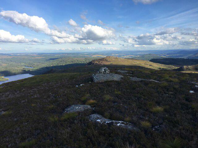 Photo could not load
NH3959 : Small cairn on Carn Faire nan Con
Steven Brown
Hill facts and local notes
Classifications
Elevation
370m
1,214 ft
Prominence
239m
Coordinates
57.5941, -4.6859
NH395591
OS Map
26
Explorer: 437S
At the Summit
The summit features a classic stone cairn, perfect for those victory selfies once you've conquered the peak. There’s also a stunning panoramic view point for taking in the beauty of the Highlands.
Terrain & Geology
Carn Faire nan Con is primarily composed of granite, which is typical of the Scottish Highlands. This rock type provides excellent stability and support for hikers, and is often accompanied by patches of schist in the lower areas. The mountain's rugged terrain showcases glacial features, evidence of its dramatic geological history.
Views & Scenery
From the summit, hikers can enjoy views of Loch Duich and the jagged peaks of the Five Sisters of Kintail. On a clear day, even the Isle of Skye beckons in the distance.
History & Heritage
Name Origin
The name 'Carn Faire nan Con' translates to 'Hill of the Fair Dogs' in Scots Gaelic, referring possibly to ancient legends or local wildlife.
Historical Significance
This mountain is part of a historic landscape that has been inhabited for thousands of years, with nearby ruins and ancient sites hinting at its cultural significance.
Getting There & Facilities
Check current local access restrictions, parking rules and transport timetables before travelling. These notes do not confirm public access to the summit.
Parking
The nearest parking area is located at the end of the A87 road, with a designated spot near the base of the Glen Shiel trail. It's a small car park but is usually sufficient for the number of hikers.
Public Transport
The nearest bus service operates from Kyle of Lochalsh to Inverness, with some connections available to Ratagan via local taxi.
Nearby Facilities
There are no facilities directly on the mountain, but Kyle of Lochalsh offers restaurants, cafés, and toilets. Remember to pack your snacks for the trail!
Safety Information
Known Hazards
- Sudden weather changes are common; be prepared for rain or high winds. Some sections can be boggy, so waterproof boots are advisable.
General Safety Tips
- Check weather conditions before setting out
- Carry appropriate clothing and equipment
- Let someone know your planned route
- Take a map, compass, and GPS device
- Carry emergency supplies: food, water, first aid kit, torch
Hills
Some common questions about the hills answered
Are there group walks up Carn Faire nan Con?
Many walkers use Walkmates to join or organise walks with others. You can check for group walks around Carn Faire nan Con through the maps
Are there other walkers around Carn Faire nan Con?
Activity varies by location and time, but Walkmates lets you see whether others have shared walks or shown interest in this area. Find other people through the walking friends search walking friends for Carn Faire nan Con search or of course create your own walk for Carn Faire nan Con
Can I organise a walk to Carn Faire nan Con?
Yes. If there aren’t any walks listed already, you can create a walk and make it available for others to join.
If you're signed up to Walkmates, you can create a walk to Carn Faire nan Con.
How do I find a walk up this hill?
There are often multiple ways to walk this hill, depending on experience and route preference. Walkmates helps you explore walks and routes that others have shared.
Can I suggest a new route up Carn Faire nan Con?
Yes. You can suggest or create routes to share with others. Walkmates focuses on the social side of walking, so routes are used to help people organise walks and explore areas together, rather than as detailed navigation tools or route libraries.
Other uses really appreciate knowledgeable walkers sharing their routes. Share your favourite route to Carn Faire nan Con here
The is an error or something incorrect about this hill. How do I let you know?
We always strive to keep the information on Walkmates as accurate as possible. If you find an error, please let us know through the contact form and we'll aim to correct it as quickly as possible
Community Discussion
Comments
Location
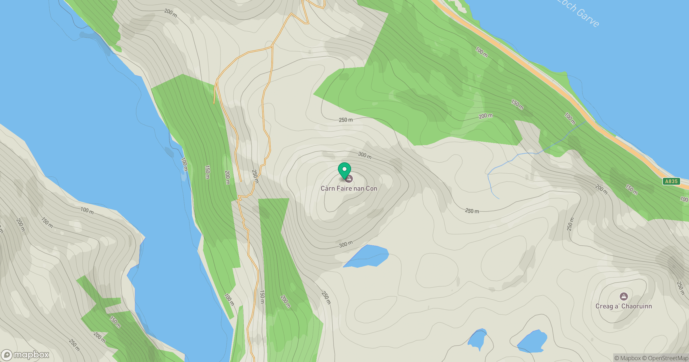
Grid reference: NH395591
View on OpenStreetMapOpens a map in a new tab, centred on the hill.
Hills within 30 km
Straight-line distance, not a walking route or confirmation of access.
Cul Mor
393m
Sgurr a' Choire Ghlais
1,084m
Sgurr Marcasaidh
580m
Little Wyvis
763m
Carn na Dubh Choille
480m
No comments yet. Be the first.