
Beinn a' Bhric
Good walks are even better shared.
Overview
Beinn a' Bhric
Nestled in the heart of the Scottish Highlands, Beinn a' Bhric rises majestically to an elevation of 865 meters. As one of the recognized Munros, it challenges hikers with an ascent that is both rewarding and picturesque.
Geology
The mountain's geology is a feast for the eyes and a treasure for geologists. Mainly composed of schists and granites, Beinn a' Bhric is a testament to the region's rugged history shaped by ancient glacial movements, offering stunning rock formations.
Access
Getting there is half the adventure. You can park at a layby along the A82 (NH344654). Keep in mind that this parking area can fill quickly on sunny weekends, so arriving early is wise. If you prefer public transport, Fort William has bus services that can take you close to the trailhead, albeit infrequently.
Routes
The most popular route begins from the A82. Spanning about 8.5 km, this moderate route takes roughly 4.5 hours to complete. It’s a delightful mix of heather-covered hills and rocky outcrops, with the summit's large cairn awaiting your arrival for those all-important selfies.
Summit Features
Once you’ve battled the ascent and reached the summit, you will be greeted by a stunning view and a large cairn - a perfect place to catch your breath. Make sure to snap some photos; the summit is not just a height, but a badge of honour!
Views
The summit rewards hikers with breathtaking panoramic views. Look out for the Ben Nevis range to the northwest and, on the right day, you might even see the shimmering waters of Loch Ness in the distance. For the best experience, visit during spring or autumn when the landscape is bursting with colour.
Hazards
While the trails are generally well marked, be cautious of loose rocks and always be prepared for the unpredictable Scottish weather. And as an additional note, you might encounter boggy patches, so sturdy boots are a must.
Nearby Summits
If you’re in the mood for more hiking, consider the nearby Stob Coire an Lochain (1004 meters) and Meall na Teanga (953 meters). Both offer excellent challenges and splendid views.
Facilities
Nearest facilities can be found in Fort William, about 25 km to the north, where you will find cafes and public toilets. Pack a little something as hiking burns a lot of calories – a munch on some homemade flapjack is always a good choice!
History
Beinn a' Bhric’s name means 'the hill of the speckled one' which reflects the patchy terrain and colourful vegetation. Historically, it has inspired local folklore, stirring curiosity and admiration for its imposing stature.
Conclusion
In summary, Beinn a' Bhric is not just another hill – it’s a journey through scenery and history, and a rite of passage for any avid hiker. Every footstep is a step into the wild heart of Scotland. Happy hiking!
Explore routes near Beinn a' Bhric
Public walks starting within 80 km of this hill. Nearby does not mean a route reaches the summit; check its map and access before setting out.
Glen Affric: Coire Loch Woodland Trail
View route
Inverness: River Ness and Caledonian Canal circuit
View route
Beinn Eighe Lancaster Wreckage at Coire Mhic Fhearchair
View route
Loch Migdale from Torroy: Spinningdale pinewood and loch shore walk
View route
Route planning notes
These notes describe possible approaches, not verified navigable routes or permission to cross land. Check current paths, local access rules and conditions before setting out.
From the A82
This popular route begins at a layby on the A82, allowing easy access to Beinn a' Bhric. The path meanders through heather-laden hills before a steady ascent to the summit.
Make a day of it, together
Find someone to share the walk with, or organise a day out along a route you like.
Hill facts and local notes
Classifications
Elevation
442m
1,450 ft
Prominence
108m
Coordinates
57.6457, -4.7755
NH344651
OS Map
20
Explorer: 436S 437S
At the Summit
The summit is marked by a large cairn, offering a perfect spot for hikers to rest and take in the views. It's also a great place for the obligatory summit photo – just don’t forget to smile!
Terrain & Geology
Beinn a' Bhric is primarily composed of schists and granites, typical of the geology found throughout the Highlands. The rock formations offer glimpses into the earth's ancient history, with some features shaped by glacial activity.
Views & Scenery
Panoramic views of the surrounding peaks, including the Ben Nevis range to the northwest and the glens below. On clear days, Loch Ness can be spotted shimmering in the east.
History & Heritage
Name Origin
The name Beinn a' Bhric translates to 'the hill of the speckled one', possibly referring to the varied colours of the rocks and heather.
Historical Significance
The mountain holds cultural significance in Scottish folklore, and its striking presence in the skyline has inspired many local legends.
Getting There & Facilities
Check current local access restrictions, parking rules and transport timetables before travelling. These notes do not confirm public access to the summit.
Parking
There is a parking area along the A82 (NH344654) which can accommodate several vehicles. Arrive early during peak season as spaces fill quickly.
Public Transport
Bus services run from nearby Fort William to the A82. Check local schedules, as they can be infrequent.
Nearby Facilities
Public toilets are available in Fort William. A variety of cafes, restaurants, and shops can be found there as well. Remember to fuel up – hiking is hungry work!
Safety Information
Known Hazards
- Loose rocks on the ascent, rapidly changing weather conditions, and the potential for boggy ground in lower areas.
General Safety Tips
- Check weather conditions before setting out
- Carry appropriate clothing and equipment
- Let someone know your planned route
- Take a map, compass, and GPS device
- Carry emergency supplies: food, water, first aid kit, torch
Hills
Some common questions about the hills answered
Are there group walks up Beinn a' Bhric?
Many walkers use Walkmates to join or organise walks with others. You can check for group walks around Beinn a' Bhric through the maps
Are there other walkers around Beinn a' Bhric?
Activity varies by location and time, but Walkmates lets you see whether others have shared walks or shown interest in this area. Find other people through the walking friends search walking friends for Beinn a' Bhric search or of course create your own walk for Beinn a' Bhric
Can I organise a walk to Beinn a' Bhric?
Yes. If there aren’t any walks listed already, you can create a walk and make it available for others to join.
If you're signed up to Walkmates, you can create a walk to Beinn a' Bhric.
How do I find a walk up this hill?
There are often multiple ways to walk this hill, depending on experience and route preference. Walkmates helps you explore walks and routes that others have shared.
Can I suggest a new route up Beinn a' Bhric?
Yes. You can suggest or create routes to share with others. Walkmates focuses on the social side of walking, so routes are used to help people organise walks and explore areas together, rather than as detailed navigation tools or route libraries.
Other uses really appreciate knowledgeable walkers sharing their routes. Share your favourite route to Beinn a' Bhric here
The is an error or something incorrect about this hill. How do I let you know?
We always strive to keep the information on Walkmates as accurate as possible. If you find an error, please let us know through the contact form and we'll aim to correct it as quickly as possible
Community Discussion
Comments
Location
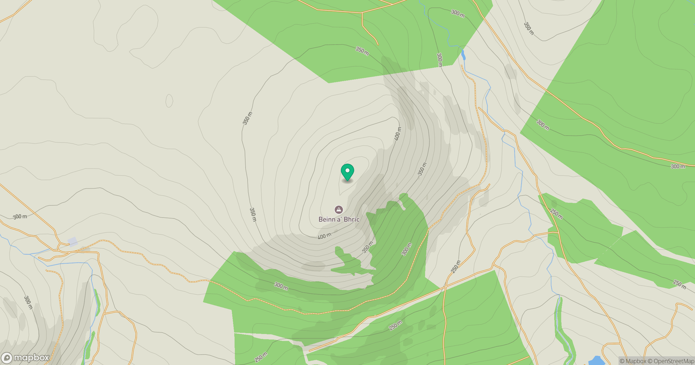
Grid reference: NH344651
View on OpenStreetMapOpens a map in a new tab, centred on the hill.
Hills within 30 km
Straight-line distance, not a walking route or confirmation of access.
Cul Mor
393m
Seana Bhraigh
926m
Sgurr a' Choire Ghlais
1,084m
Beinn nan Cabag
474m
Meallan a' Mhuthaidh Mor
513m
No comments yet. Be the first.