
Beinn a' Bhutha
Good walks are even better shared.
Overview
Beinn a' Bhutha
Elevation: 799 meters
Location: Scottish Highlands
Nestled in the heart of the Scottish Highlands, Beinn a' Bhutha stands proud as a Munro with impressive views and a moderate climb that can leave both seasoned hikers and newbies feeling accomplished.
Geology
The geology of Beinn a' Bhutha is captivating, primarily composed of durable quartzite which lends to its rugged character and the striking steep crags. It offers an exciting terrain for adventurous climbers and photographers alike.
Route Description
The most popular route to Beinn a' Bhutha is the North East Ridge Route. Starting from a small car park, this well-marked path provides access with manageable gradients. With a distance of about 7.5 km, plan for a round trip time of around 3.5 hours, depending on your pace and photo stops (and perhaps some wildlife-watching!). The route includes a delightful mix of rocky paths and grassy slopes – so don’t forget your wellies, just in case!
Summit Features
Upon reaching the summit, expect cheers and possibly a 'sigh of relief.' The summit is marked by a modest stone cairn. From here, the 360-degree views are nothing short of spectacular. On a clear day, the sight of the distant Cairngorms is a treat for the eyes and a balm for the soul.
Terrain Type
The terrain is primarily rocky, interspersed with patches of grass and some boggy areas at the base. Be prepared for a bit of a mix, ideal for those who love a good mountain scramble followed by a picturesque grassy picnic!
Views and Best Seasons
While the summit serves a visual feast year-round, the late spring to early autumn months offer the best vistas. The rich colours of the highland landscapes are simply breathtaking, so grab your camera!
Hazards
As with many mountains, Beinn a' Bhutha comes with its own set of hazards: unpredictable weather can spring up suddenly, making it essential to check forecasts. Also, there are some loose rocks along the paths, which can be a bit slippery, especially after rain. And don’t forget those pesky midges in summer – a good insect repellent will be your best mate!
Access
Nearest Parking: A cozy parking area at the end of the approach road, but it fills up fast on sunny weekends, so set that alarm early.
Public Transport: Bus services from Newtonmore can help you arrive if your legs are tired of driving!
Nearest Town: Dalwhinnie is roughly 15 km away, charming and welcoming.
Facilities
Facilities are not abundant on the mountain itself, but fear not! Dalwhinnie has got some local amenities including a shop and a distillery that promises a well-earned dram post-hike.
History
The name itself, Beinn a' Bhutha, hints at historical significance, with translations suggesting a connection to the usage of the land by local clans. As a favourite spot for Munro-baggers, it stands as a testament to the thriving culture around Scottish climbing and exploration.
With so much beauty and camaraderie awaiting hikers at Beinn a' Bhutha, it’s truly a gem not to be missed. Just remember: pack well, tread carefully, and leave only footmarks behind!
Happy hiking!
Explore routes near Beinn a' Bhutha
Public walks starting within 80 km of this hill. Nearby does not mean a route reaches the summit; check its map and access before setting out.
Ben Klibreck
View route
Loch Migdale from Torroy: Spinningdale pinewood and loch shore walk
View route
Fairy Lochs Liberator Wreckage Circuit
View route
Route planning notes
These notes describe possible approaches, not verified navigable routes or permission to cross land. Check current paths, local access rules and conditions before setting out.
North East Ridge Route
This popular route begins at the nearby car park and follows a well-trodden path up the northern flanks. The ascent is steady with a few rocky sections.
Make a day of it, together
Find someone to share the walk with, or organise a day out along a route you like.
Hill facts and local notes
Classifications
Elevation
547m
1,796 ft
Prominence
143m
Coordinates
58.2682, -4.9011
NC299347
OS Map
15
Explorer: 442E 445
At the Summit
The summit features a small stone cairn and offers stunning panoramic views of the surrounding hills and glens.
Terrain & Geology
The mountain consists predominantly of quartzite, which forms steep crags and rugged terrain, providing excellent opportunities for rock climbing and wild vistas.
Views & Scenery
On a clear day, you can spot the distant peaks of the Cairngorms and the sweeping valleys of the highlands.
History & Heritage
Name Origin
The name 'Beinn a' Bhutha' translates to 'Mountain of the Bute', possibly referring to historical clans or geographical references.
Historical Significance
This mountain is a favourite among Munro-baggers, adding to its status in Scottish mountaineering culture.
Getting There & Facilities
Check current local access restrictions, parking rules and transport timetables before travelling. These notes do not confirm public access to the summit.
Parking
There is a small parking area at the end of the approach road, which can accommodate around 8-10 cars. Arrive early during weekends!
Public Transport
The nearest bus station is in Newtonmore, approximately 15 km away. Buses run daily from major towns.
Nearby Facilities
There are no facilities directly on the mountain, but nearby Dalwhinnie has a shop and a distillery for post-hike refreshments.
Safety Information
Known Hazards
- Watch out for sudden weather changes, loose rocks on paths, and midges in summer! Good quality boots and a sense of adventure are a must.
General Safety Tips
- Check weather conditions before setting out
- Carry appropriate clothing and equipment
- Let someone know your planned route
- Take a map, compass, and GPS device
- Carry emergency supplies: food, water, first aid kit, torch
Hills
Some common questions about the hills answered
Are there group walks up Beinn a' Bhutha?
Many walkers use Walkmates to join or organise walks with others. You can check for group walks around Beinn a' Bhutha through the maps
Are there other walkers around Beinn a' Bhutha?
Activity varies by location and time, but Walkmates lets you see whether others have shared walks or shown interest in this area. Find other people through the walking friends search walking friends for Beinn a' Bhutha search or of course create your own walk for Beinn a' Bhutha
Can I organise a walk to Beinn a' Bhutha?
Yes. If there aren’t any walks listed already, you can create a walk and make it available for others to join.
If you're signed up to Walkmates, you can create a walk to Beinn a' Bhutha.
How do I find a walk up this hill?
There are often multiple ways to walk this hill, depending on experience and route preference. Walkmates helps you explore walks and routes that others have shared.
Can I suggest a new route up Beinn a' Bhutha?
Yes. You can suggest or create routes to share with others. Walkmates focuses on the social side of walking, so routes are used to help people organise walks and explore areas together, rather than as detailed navigation tools or route libraries.
Other uses really appreciate knowledgeable walkers sharing their routes. Share your favourite route to Beinn a' Bhutha here
The is an error or something incorrect about this hill. How do I let you know?
We always strive to keep the information on Walkmates as accurate as possible. If you find an error, please let us know through the contact form and we'll aim to correct it as quickly as possible
Community Discussion
Comments
Location
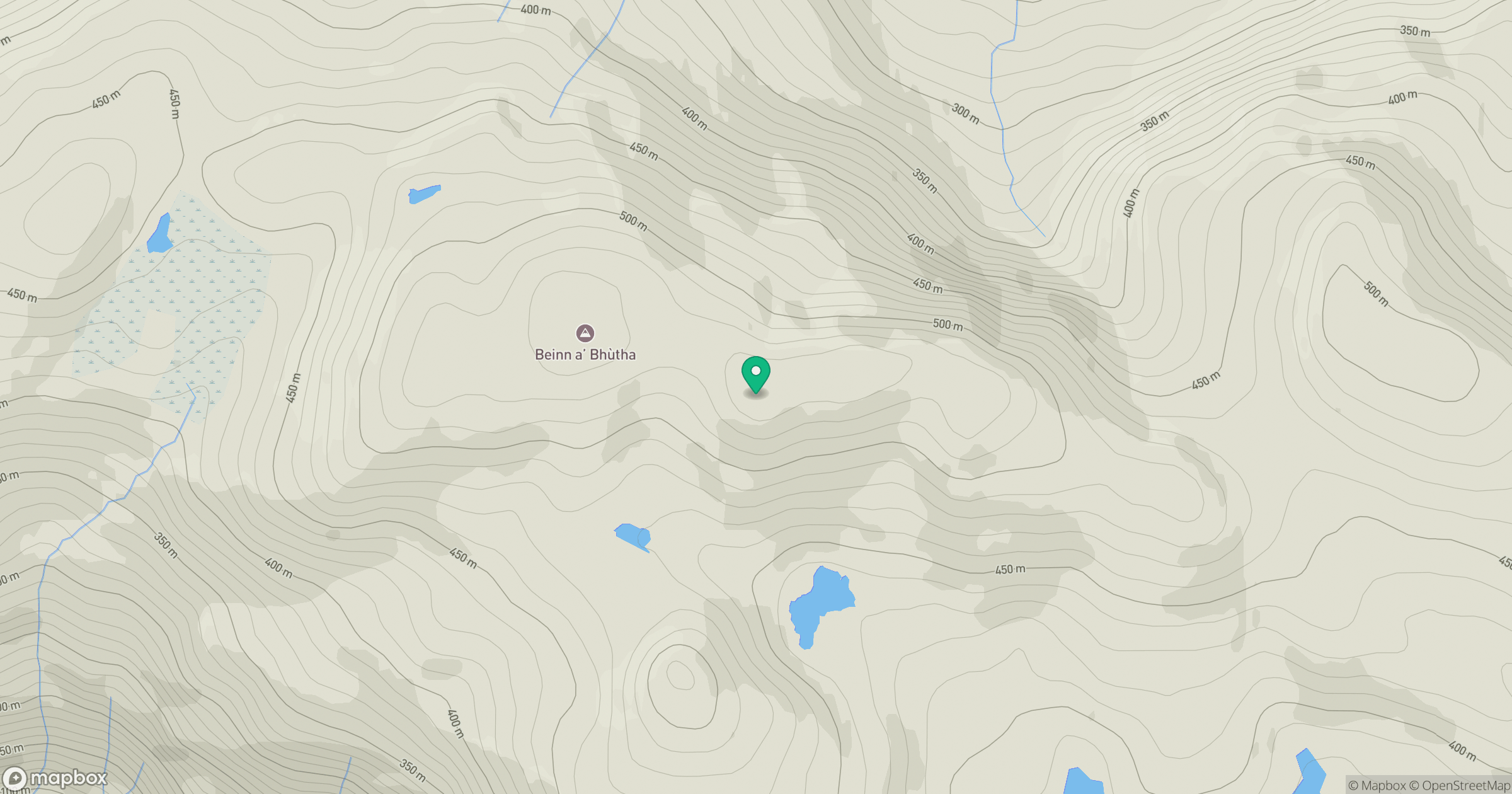
Grid reference: NC299347
View on OpenStreetMapOpens a map in a new tab, centred on the hill.
Hills within 30 km
Straight-line distance, not a walking route or confirmation of access.
Ben Stack
721m
Ben More Assynt
999m
Quinag - Sail Gharbh
809m
Quinag - Spidean Coinich
764m
Quinag - Sail Ghorm [Sail Gorm]
776m
No comments yet. Be the first.