

Suilven
Good walks are even better shared.
NC1518 : Caisteal Liath, Suilven
Julian Paren Photo source
Overview
Suilven is a 731.4 m Graham in Assynt, with Caisteal Liath forming its highest, western summit. Its sandstone ridge rises above a maze of rocky knolls and lochs. The usual Glencanisp approach is a full mountain day with a long walk in, a steep climb to Bealach Mòr and short easy scrambling sections. The more demanding eastern tops are separate objectives.
Suilven
Suilven rises above Assynt’s rocky knolls and lochs. Caisteal Liath, its western summit, is the highest point at 731.4 m and has a large cairn on a grassy dome.
Planning the walk
The usual route starts at the walkers’ car park near Glencanisp, passes the lodge, approaches from the north and climbs Bealach Mòr before following the ridge west to Caisteal Liath. Return the same way to the car park. Allow 7–9 hours for this approximately 20 km round trip.
The Inverkirkaig alternative follows the Kirkaig valley and Fionn Loch, climbs the southern side of Bealach Mòr and reaches Caisteal Liath before retracing the route. Allow 8–10 hours; the southern ascent is rough and steep. The eastern approach from the A835 follows Cam Loch and Loch na Gainimh and makes an even longer day.
Terrain and safety
The climb to Bealach Mòr is very steep, with easy scrambling on the ridge to Caisteal Liath. The eastern tops require harder, exposed scrambling and are not part of these main-summit routes. Poor visibility, wet rock and strong winds add difficulty. Winter conditions require winter mountaineering skills. Plan for limited mobile reception and the long walk back.
Access
Use the small Foundation walkers’ car park at NC107219. General hillwalker parking is not provided at Glencanisp Lodge. Keep the single-track road and passing places clear. Lochinver has public toilets; carry supplies for the mountain day.
Landscape and heritage
Torridonian sandstone stands above ancient Lewisian gneiss in a landscape shaped by ice. The name is commonly interpreted as “pillar mountain”; Caisteal Liath means “grey castle”. The Assynt Foundation’s community buyout in 2005 included Suilven, and a 2017–2018 project restored the northern path. The origin of the ridge’s drystone wall remains uncertain.
Explore routes near Suilven
Walks starting near this hill. Open a route to check its map, distance and full itinerary.
Ben Klibreck
View route
Fairy Lochs Liberator Wreckage Circuit
View route
Loch Migdale from Torroy: Spinningdale pinewood and loch shore walk
View route
Beinn Eighe Lancaster Wreckage at Coire Mhic Fhearchair
View route
Route planning notes
These notes describe possible approaches. Check a route's map and access information when planning your walk.
Glencanisp to Caisteal Liath (out and back)
Start at the walkers' car park at the public-road end near Glencanisp (NC107219). Go past the lodge and along the northern approach to Bealach Mòr, then west to Caisteal Liath; retrace the ridge, gully and approach to the car park. About 20 km return, allowing 7–9 hours. A long remote walk with a very steep climb and short easy scrambling sections; eastern tops are excluded.
Inverkirkaig to Caisteal Liath (out and back)
Start at the Inverkirkaig riverside car park (NC086194). Follow the Kirkaig valley past the falls turn-off and Fionn Loch, ascend the south side of Bealach Mòr, then continue west to Caisteal Liath. Retrace the same route to Inverkirkaig. Allow 8–10 hours. Rough moorland and a steep, loose southern ascent make this a strenuous day; visiting the falls is an optional detour. Eastern tops are excluded.
Elphin/A835 via Cam Loch (out and back)
From the signed Lochinver path on the A835 west of Ledmore, follow Cam Loch, Lochan Fada and Loch na Gainimh to the north-side ascent via Bealach Mòr to Caisteal Liath. Return by the same route to the A835. This is a very long remote approach with bogs, stream crossings and sections requiring careful navigation. The eastern tops are excluded; use the designated roadside car park and plan the road link.
Make a day of it, together
Find someone to share the walk with, or organise a day out along a route you like.
Photo Gallery
View all Photo could not load
NC1518 : Caisteal Liath, Suilven
Julian Paren
 Photo could not load
NC1518 : Suilven
Ike Gibson
 Photo could not load
NC1518 : Suilven from above Glen Canisp Lodge
Alan White
 Photo could not load
NC1518 : Suilven's Western Summit (GM/NS-060) looking SE
John Earnshaw
 Photo could not load
NC1518 : View of Suilven from Hill by East Coast
jamie Wright
 Photo could not load
NC1518 : Caisteal Liath on Suilven
Walter Baxter
 Photo could not load
NC1518 : Aerial view of Suilven from the north west
Adrian Beney
 Photo could not load
NC1518 : Approach to Caisteal Liath summit, Suilven
Paul Taylor
 Photo could not load
NC1518 : Ridge leading up to Caisteal Liath, Suilven
Colin Park

NC1518 : Suilven from the northwest
Jim Barton
Hill facts and local notes
Classifications
Elevation
731m
2,400 ft
Prominence
496m
Coordinates
58.1155, -5.1368
NC153183
OS Map
15
Explorer: 442W
At the Summit
Caisteal Liath, the western and highest summit, is a broad grassy dome with a large cairn. Cliffs surround the summit area; the walking descent returns towards Bealach Mòr.
Terrain & Geology
Suilven is formed from Torridonian sandstone above much older Lewisian gneiss. Ice erosion helped shape the steep-sided ridge and the surrounding landscape of rocky knolls and lochs.
Views & Scenery
In clear weather, Caisteal Liath looks across the loch-studded Assynt landscape towards Canisp, Quinag, Cul Mor, Cul Beag and Stac Pollaidh, with Lochinver and the sea to the west. Looking east reveals Suilven’s sharply contrasting ridge and eastern tops.
History & Heritage
Name Origin
Suilven is usually interpreted as “pillar mountain”, reflecting Norse influence on the name. Caisteal Liath, the main summit, means “grey castle” in Gaelic.
Historical Significance
Suilven is part of the Glencanisp Estate, bought with neighbouring Drumrunie by the local community through the Assynt Foundation in 2005. The northern ascent path was restored in a major 2017–2018 partnership project to reduce erosion and protect fragile habitats.
Getting There & Facilities
Parking
For the usual northern route, use the Assynt Foundation walkers' car park at NC107219, at the end of the public road from Lochinver towards Glencanisp. Space is limited. Parking at Glencanisp itself is reserved for residents, workers and other authorised visitors; do not assume it is general hillwalker parking. Keep access roads and passing places clear. The Inverkirkaig route starts at its riverside car park around NC086194. For the eastern approach, the Foundation identifies a small A835 car park at NC229121 between Elphin and Ledmore Junction.
Public Transport
There is no direct public transport to the Glencanisp walkers' car park. If travelling to Lochinver by bus, check current services and plan the extra road approach and return before setting out; local connections may not fit a full mountain day.
Nearby Facilities
Lochinver has public toilets. Carry food and water for the whole walk; there are no summit facilities. Suileag Bothy lies off the northern approach and offers basic shelter.
Safety Information
Known Hazards
- The approaches are long and remote, with little mobile reception; carry reliable navigation, food, water and enough daylight for the return.
- The ascent and descent of Bealach Mòr are very steep. Wet or loose rock, boggy ground and strong winds can make progress slow.
- Caisteal Liath is surrounded by cliffs. Stay on the established ridge approach and return to Bealach Mòr rather than attempting a direct descent.
- Meall Meadhonach and Meall Beag involve substantially harder, exposed scrambling than the main summit; a full ridge traverse requires appropriate mountaineering experience.
Seasonal Hazards
Snow and ice turn the steep gullies and rocky ridge into winter mountaineering terrain. Short winter days leave little margin for the long approach and return. Heavy rain worsens bogs and stream crossings; wind and low cloud can be serious in any season.
General Safety Tips
- Check weather conditions before setting out
- Carry appropriate clothing and equipment
- Let someone know your planned route
- Take a map, compass, and GPS device
- Carry emergency supplies: food, water, first aid kit, torch
Hills
Some common questions about the hills answered
Are there group walks up Suilven?
Many walkers use Walkmates to join or organise walks with others. You can check for group walks around Suilven through the maps
Are there other walkers around Suilven?
Activity varies by location and time, but Walkmates lets you see whether others have shared walks or shown interest in this area. Find other people through the walking friends search walking friends for Suilven search or of course create your own walk for Suilven
Can I organise a walk to Suilven?
Yes. If there aren’t any walks listed already, you can create a walk and make it available for others to join.
If you're signed up to Walkmates, you can create a walk to Suilven.
How do I find a walk up this hill?
There are often multiple ways to walk this hill, depending on experience and route preference. Walkmates helps you explore walks and routes that others have shared.
Can I suggest a new route up Suilven?
Yes. You can suggest or create routes to share with others. Walkmates focuses on the social side of walking, so routes are used to help people organise walks and explore areas together, rather than as detailed navigation tools or route libraries.
Other uses really appreciate knowledgeable walkers sharing their routes. Share your favourite route to Suilven here
The is an error or something incorrect about this hill. How do I let you know?
We always strive to keep the information on Walkmates as accurate as possible. If you find an error, please let us know through the contact form and we'll aim to correct it as quickly as possible
Community Discussion
Comments
Location
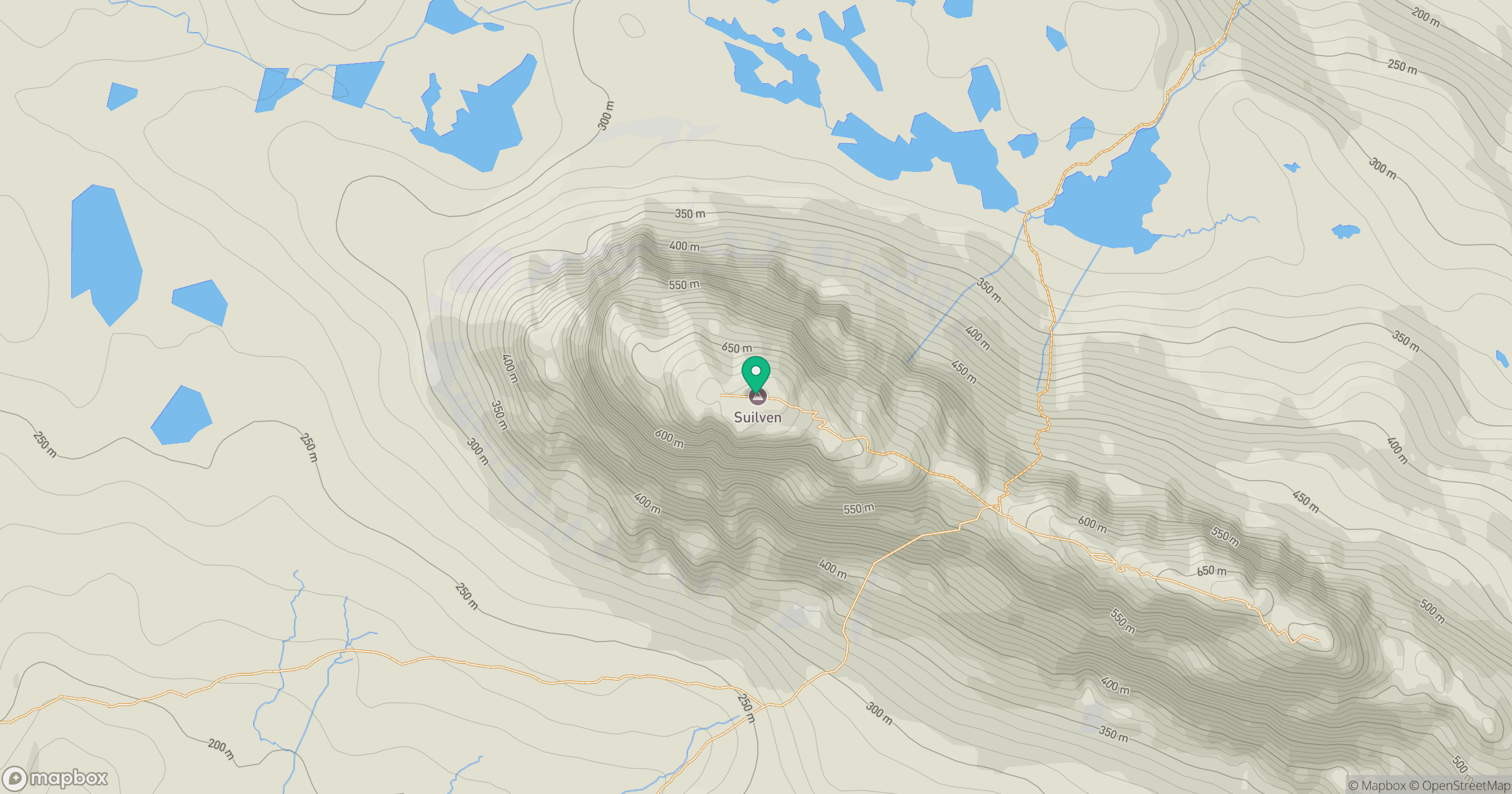
Grid reference: NC153183
View on OpenStreetMapOpens a map in a new tab, centred on the hill.
No comments yet. Be the first.