
Windmill Hill
Good walks are even better shared.
Overview
Windmill Hill
Nestled in the North Wessex Downs, Windmill Hill is not just another hill—it's a delightful escape into nature's embrace. With an elevation of 224 meters, it stands as a proud beacon over the lush landscape.
Geology
Made predominantly of chalk and flint, Windmill Hill's geology not only provides stunning views, but it also supports a diverse range of flora and fauna. The sedimentation process that formed these hills dates back to ancient seas, making it a geological treasure trove!
Routes
The favourite route to reach the summit is via The Ridgeway, a historic path that invites you to wander through rolling hills and serene meadows. It's about a 12km trek that should take around 4 hours. Just enough time to contemplate the mysteries of life—like why the sheep are always staring at you.
Summit Features
At the top, you'll be greeted by a trig point—perfect for those Instagram shots, and ample grassy areas ideal for a post-hike rest and sandwiches. Just be wary of any ornery sheep; they think they own the place!
Terrain
Expect to see a mix of grassy slopes and pockets of woodland. The paths are generally well-maintained, making it accessible for most hikers. Whether you're a seasoned trekker or a Sunday stroller, what's important is to enjoy the journey.
Views
Once at the summit, the views are spectacular. You can see the Thames Valley spread out before you and even catch sight of the Cotswolds in the distance on a clear day. The best times to visit for views are during the spring and autumn months, where the weather graces you with beautiful skies. Sunset? Absolutely breathtaking!
Hazards
While the risks here are relatively low, don’t ignore the possibility of sheep stealing your sandwiches—they're surprisingly crafty!
Nearby Summits
For those with stamina, nearby Coombe Hill and Walbury Hill also offer delightful hikes and views that can easily fill your day.
Access
Parking is available in a small layby on the B4000. For public transport, Hungerford station is the closest, though it’s a trek away. Hungry for a bite post-hike? The quaint town of Hungerford, just a stone's throw away, has plenty of cafes and pubs to refuel.
History
Windmill Hill boasts a fascinating history, drawing its name from the windmills that used to dot the surrounding area. Archaeological digs have shown that people have called this area home for millennia, weaving the histories of settlers into the very fabric of this hill.
So grab your stout walking boots and explore Windmill Hill! You'll find a pocket of serenity and a splash of history right here in the English countryside.
Explore routes near Windmill Hill
Walks starting near this hill. Open a route to check its map, distance and full itinerary.
Frensham Little Pond and Snowball Ridge Walk
View route
Hinton Ampner: Dutton Estate Woodland and Downland Circuit
View route
Hindhead Sailor's Stroll to Gibbet Hill
View route
Frimley Lodge Park to Mytchett Lake and Great Bottom Flash
View route
Route planning notes
These notes describe possible approaches. Check a route's map and access information when planning your walk.
The Ridgeway
A classic long-distance path leading to Windmill Hill, offering a scenic stroll through open countryside and along ancient tracks.
Make a day of it, together
Find someone to share the walk with, or organise a day out along a route you like.
Hill facts and local notes
Classifications
Elevation
151m
495 ft
Prominence
37m
Coordinates
51.1412, -0.9693
SU722385
OS Map
186
Explorer: OL33 133 144E
At the Summit
The summit features a prominent trig point and a picturesque view over the surrounding countryside. A lovely grassy expanse at the top makes for a perfect picnic spot.
Terrain & Geology
Windmill Hill is primarily composed of chalk and flint, typical of the North Wessex Downs, which gives way to a rich biodiversity and beautiful landscapes. The hill has formed due to sedimentation from ancient seabeds and glacial activity.
Views & Scenery
From the summit, hikers can enjoy sweeping views of the Thames Valley, the North Wessex Downs, and on clear days, the distant Cotswolds.
History & Heritage
Name Origin
The name 'Windmill Hill' originates from historical windmills that were once present in the area, serving the agricultural communities.
Historical Significance
Windmill Hill has a rich history, with archaeological findings in the vicinity indicating human activity since prehistoric times.
Getting There & Facilities
Parking
There is a small layby on the B4000 near the start of The Ridgeway.
Public Transport
The nearest train station is in Hungerford, approximately 6 miles away, with bus services available to the area.
Nearby Facilities
The nearby town of Hungerford has several cafes and pubs, as well as public toilets.
Safety Information
Known Hazards
- Watch out for sheep grazing in the area; they might steal your lunch if you're not careful!
General Safety Tips
- Check weather conditions before setting out
- Carry appropriate clothing and equipment
- Let someone know your planned route
- Take a map, compass, and GPS device
- Carry emergency supplies: food, water, first aid kit, torch
Hills
Some common questions about the hills answered
Are there group walks up Windmill Hill?
Many walkers use Walkmates to join or organise walks with others. You can check for group walks around Windmill Hill through the maps
Are there other walkers around Windmill Hill?
Activity varies by location and time, but Walkmates lets you see whether others have shared walks or shown interest in this area. Find other people through the walking friends search walking friends for Windmill Hill search or of course create your own walk for Windmill Hill
Can I organise a walk to Windmill Hill?
Yes. If there aren’t any walks listed already, you can create a walk and make it available for others to join.
If you're signed up to Walkmates, you can create a walk to Windmill Hill.
How do I find a walk up this hill?
There are often multiple ways to walk this hill, depending on experience and route preference. Walkmates helps you explore walks and routes that others have shared.
Can I suggest a new route up Windmill Hill?
Yes. You can suggest or create routes to share with others. Walkmates focuses on the social side of walking, so routes are used to help people organise walks and explore areas together, rather than as detailed navigation tools or route libraries.
Other uses really appreciate knowledgeable walkers sharing their routes. Share your favourite route to Windmill Hill here
The is an error or something incorrect about this hill. How do I let you know?
We always strive to keep the information on Walkmates as accurate as possible. If you find an error, please let us know through the contact form and we'll aim to correct it as quickly as possible
Community Discussion
Comments
Location
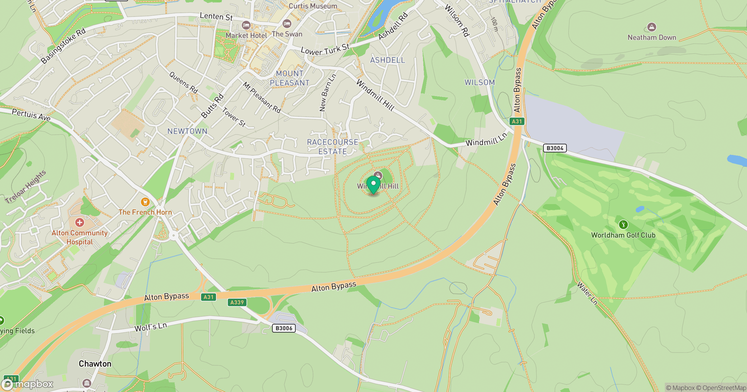
Grid reference: SU722385
View on OpenStreetMapOpens a map in a new tab, centred on the hill.
Nearby Hills
Leith Hill
294m
Ditchling Beacon
248m
Worcestershire Beacon
425m
Glastonbury Tor
158m
Titterstone Clee Hill
533m
No comments yet. Be the first.