
Tom na Slaite
Good walks are even better shared.
Overview
Tom na Slaite: The Gentle Highland Giant
Nestled in the heart of the Scottish Highlands, Tom na Slaite stands as a proud Marilyn with an elevation of 657 meters. This gentle giant might not be the tallest in the region, but don't let that fool you—its charm and rugged beauty are a magnet for outdoor enthusiasts.
Geology
Tom na Slaite is primarily composed of ancient schist and granite, giving hikers a glimpse into millions of years of geological history. Exploring its rocky terrain feels like walking through a natural museum of the earth’s history, with each rock telling a story of erosion and formation.
Routes
The popular Eastern Approach offers a delightful 8.5 km hike that will take approximately 3.5 hours to complete. Starting from Glen Shiel, this route artfully meanders upward through vibrant heather-covered slopes, before challenging you with a few rocky outcrops. It’s a moderate hike, perfect for those looking to get their boots muddy without biting off more than they can chew.
Summit Features
Upon reaching the summit, you’ll be greeted by a humble cairn—a trustworthy beacon for fellow adventurers. Here, the panoramic views are breathtaking: on a clear day, the vistas include Loch Duich and the formidable Kintail peaks. Don’t forget to capture the moment because Instagram loves a good summit selfie!
Terrain
Expect a combination of rocky paths and lush grassy slopes, interspersed with the occasional boggy bit trying to sneak up on you. Keep your wits about you—one moment you could be dry and perched on a rock, and the next, you might find your foot taken hostage by a surprise puddle!
Views
The best times to enjoy the stunning vistas are in the late spring and early autumn. When the heather blooms, it’s a spectacle worth witnessing. And if you fancy capturing that golden hour glow, try to be there at sunset—the Highland sunset will have you questioning why you ever settled for anything less!
Hazards
As with many Scottish outings, keep an eye out for rapidly changing weather, which can lead to fog and rain, diminishing visibility in a jiffy. The rockier sections can become slippery, so tread carefully after a downpour.
Nearby Summits
For those looking for a bit more adventure, nearby summits like Beinn Fhada and Sgurr na Ciste Duibhe offer great additional hiking options.
Access
You’ll find a small car park at NH 820338, conveniently located near the trailhead, but make sure to arrive early to grab a spot! For those relying on public transport, local buses run from Inverness to Kyle of Lochalsh, though you’ll need a bit of a walk to reach the trail.
Facilities
While the mountain itself is devoid of amenities, the nearby town of Kyle of Lochalsh provides shops, handy cafes, and the all-important public toilets to make your adventure more comfortable.
History
The name 'Tom na Slaite' translates to 'hill of the slates', hinting at the rocky nature of the landscape. Historically, this area has been significant for outdoor pursuits, providing a sense of adventure for generations.
In conclusion, whether you're looking for a leisurely walk or a chance to snap some stunning Highland photos, Tom na Slaite has something for everyone. Just remember to bring your sense of adventure and a keen eye for those cheeky puddles awaiting your unsuspecting boots!
Last Updated
2023-10-01
Explore routes near Tom na Slaite
Public walks starting within 80 km of this hill. Nearby does not mean a route reaches the summit; check its map and access before setting out.
Inverness: River Ness and Caledonian Canal circuit
View route
Aviemore: Loch an Eilein and the Croft Track from Rothiemurchus
View route
Rothiemurchus: Beaver Trail and Lochan Mor
View route
Culbin Forest: Hill 99, Gravel Pit Ponds and Dragonfly Pool
View route
Route planning notes
These notes describe possible approaches, not verified navigable routes or permission to cross land. Check current paths, local access rules and conditions before setting out.
Eastern Approach
A scenic route starting from the nearby Glen Shiel, winding upwards through heather-covered slopes and rocky outcrops to the summit.
Make a day of it, together
Find someone to share the walk with, or organise a day out along a route you like.
Hill facts and local notes
Classifications
Elevation
426m
1,398 ft
Prominence
119m
Coordinates
57.3838, -3.9589
NH823342
OS Map
27
Explorer: OL60 418
At the Summit
At the summit, you'll find a modest cairn marking the high point, offering a fitting tribute to the many wanderers who have made the trek. The views from the top are nothing short of spectacular, so have your camera ready!
Terrain & Geology
Predominantly composed of ancient schist and granite, Tom na Slaite is a testament to millions of years of geological history. The rock formations provide a rugged landscape that adds character to your hiking experience.
Views & Scenery
From the summit, you can marvel at the stunning vistas of Loch Duich and the surrounding peaks of the Kintail range, where the landscape stretches as far as the eye can see.
History & Heritage
Name Origin
The name 'Tom na Slaite' is Gaelic, meaning 'hill of the slates,' likely referring to the rocky nature of the surrounding landscape.
Historical Significance
Tom na Slaite has been a popular destination for hikers and climbers for generations, offering not just an outdoor adventure but a chance to explore the rich natural beauty of the Scottish Highlands.
Getting There & Facilities
Check current local access restrictions, parking rules and transport timetables before travelling. These notes do not confirm public access to the summit.
Parking
There is a small car park at NH 820338 near the start of the Eastern Approach trail. Arrive early to ensure a parking spot, especially on weekends.
Public Transport
Public transport options are limited, but local buses from Inverness head towards the village of Morvich, followed by a short hike to the trailhead.
Nearby Facilities
While there are no facilities on the mountain itself, Kyle of Lochalsh has shops, cafes, and public toilets for hikers needing a break before or after their adventure.
Safety Information
Known Hazards
- Be wary of sudden weather changes which can lead to reduced visibility. Wet, slippery rocks can be treacherous, especially after rainfall.
General Safety Tips
- Check weather conditions before setting out
- Carry appropriate clothing and equipment
- Let someone know your planned route
- Take a map, compass, and GPS device
- Carry emergency supplies: food, water, first aid kit, torch
Hills
Some common questions about the hills answered
Are there group walks up Tom na Slaite?
Many walkers use Walkmates to join or organise walks with others. You can check for group walks around Tom na Slaite through the maps
Are there other walkers around Tom na Slaite?
Activity varies by location and time, but Walkmates lets you see whether others have shared walks or shown interest in this area. Find other people through the walking friends search walking friends for Tom na Slaite search or of course create your own walk for Tom na Slaite
Can I organise a walk to Tom na Slaite?
Yes. If there aren’t any walks listed already, you can create a walk and make it available for others to join.
If you're signed up to Walkmates, you can create a walk to Tom na Slaite.
How do I find a walk up this hill?
There are often multiple ways to walk this hill, depending on experience and route preference. Walkmates helps you explore walks and routes that others have shared.
Can I suggest a new route up Tom na Slaite?
Yes. You can suggest or create routes to share with others. Walkmates focuses on the social side of walking, so routes are used to help people organise walks and explore areas together, rather than as detailed navigation tools or route libraries.
Other uses really appreciate knowledgeable walkers sharing their routes. Share your favourite route to Tom na Slaite here
The is an error or something incorrect about this hill. How do I let you know?
We always strive to keep the information on Walkmates as accurate as possible. If you find an error, please let us know through the contact form and we'll aim to correct it as quickly as possible
Community Discussion
Comments
Location
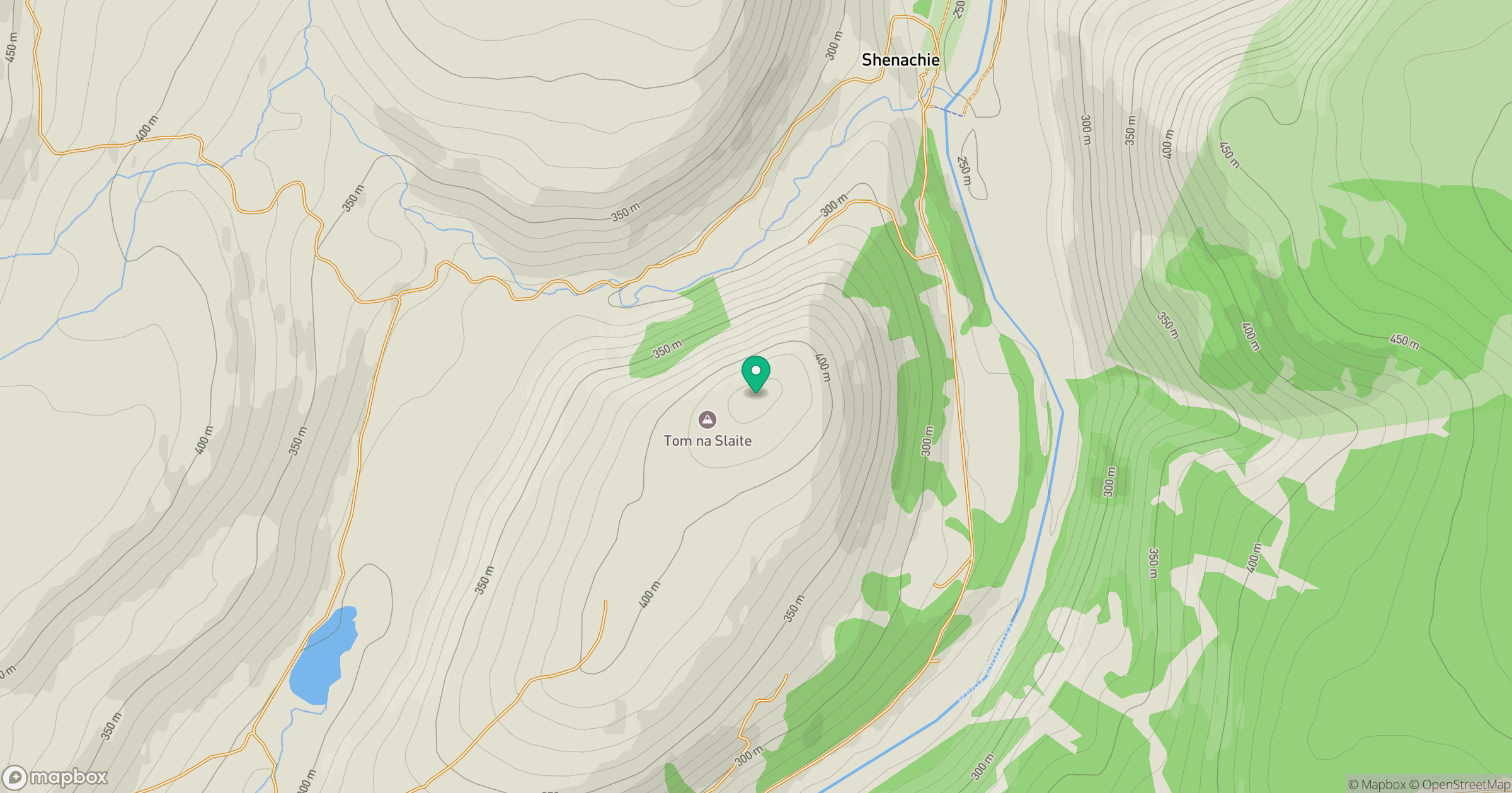
Grid reference: NH823342
View on OpenStreetMapOpens a map in a new tab, centred on the hill.
Hills within 30 km
Straight-line distance, not a walking route or confirmation of access.
Carn nan Tri-tighearnan
615m
Carn Sgumain
417m
Carn Bad nan Luibhean
471m
Carn Glas-choire
659m
Carn na h-Easgainn
617m
No comments yet. Be the first.