

Carn nan Tri-tighearnan
Good walks are even better shared.
NH8239 : Carn nan Tri-tighearnan (trig point)
Raibeart MacAoidh Photo source
Overview
Carn nan Tri-tighearnan
Nestled in the Scottish Highlands, Carn nan Tri-tighearnan stands proudly at 753 meters. Known as the 'Hill of the Three Lords', it has a significant place in both the hearts of hikers and the lore of the Scottish clans.
Geology
The mountain is primarily granite, with hard, durable rock, while the surrounding terrain is shaped by centuries of glacial activity. It's a stunning showcase of nature’s artistry, often leaving visitors spellbound by the rugged beauty and sheer scale.
Routes
One of the most popular routes is the Inverlael Path, which takes you through enchanting woodlands and rolling glens before leading to the rocky summit. Covering approximately 12 km round trip, it’s a moderate hike that takes around five hours to complete.
Summit Features
At the summit, you'll find a sizeable stone cairn that makes for an excellent selfie spot. Don't forget to bring snacks; the views are best enjoyed with a little something in hand!
Terrain
The terrain varies from rocky outcrops to grassy slopes, and you might encounter a bog or two, particularly in the wet seasons. Traipse with care, or you might find yourself knee-deep in a Scottish swamp!
Views
As you gain altitude, the panoramic views unfold in all directions. On a clear day, Ben More Assynt emerges as a majestic giant to the north, and Loch Awe glimmers invitingly in the sun. The best times to soak in these vistas are late spring and early autumn, when the skies are usually most favourable.
Hazards
Be mindful of loose rocks and an unpredictable weather system; in the Highlands, it can change quicker than you can say 'Scotland is bonnie!' Always check the forecast before setting off and carry appropriate gear.
Access
Accessing Carn nan Tri-tighearnan is straightforward. Park at Inverlael and follow the well-marked path to the summit. If you’re relying on public transport, buses from Ullapool do run to Inverlael, but don’t plan your return trip around them—flexibility is key in the Highlands!
Facilities
While facilities are limited near the mountain, Ullapool is a hub of activity with bustling cafes and shops, perfect for a post-hike meal to refuel those tired legs.
History
The mountain's name reflects its historical significance, as it is tied to local clan legends. The tales might just add a charming layer to your hiking experience!
Join many adventurous souls who have made the trek to the summit; experience the tranquility and beauty that only a Scottish hill walk can offer.
Happy hiking!
Explore routes near Carn nan Tri-tighearnan
Walks starting near this hill. Open a route to check its map, distance and full itinerary.
Culbin Forest: Hill 99, Gravel Pit Ponds and Dragonfly Pool
View route
Aviemore: Loch an Eilein and the Croft Track from Rothiemurchus
View route
Rothiemurchus: Beaver Trail and Lochan Mor
View route
Findhorn guided night walk
View route
Route planning notes
These notes describe possible approaches. Check a route's map and access information when planning your walk.
Inverlael Path
A popular route that starts from the Inverlael area, weaving through scenic woodland before ascending to the summit.
Make a day of it, together
Find someone to share the walk with, or organise a day out along a route you like.
Photo Gallery
View all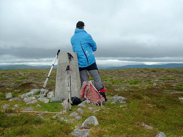 Photo could not load
NH8239 : Carn nan Tri-tighearnan (trig point)
Raibeart MacAoidh
Hill facts and local notes
Classifications
Elevation
615m
2,017 ft
Prominence
333m
Coordinates
57.4264, -3.9615
NH823390
OS Map
27
Explorer: OL60 418
At the Summit
The summit features a prominent cairn that offers a perfect spot for a well-deserved snack and panoramic views of the surrounding mountains.
Terrain & Geology
Carn nan Tri-tighearnan is primarily composed of granite, with occasional schistose rocks. The surrounding hills exhibit typical Highland geology, with glacially carved features that create a majestic landscape.
Views & Scenery
From the summit, one can see the imposing peaks of Ben More Assynt to the north and Loch Awe in the distance. On a clear day, the vistas are simply breathtaking.
History & Heritage
Name Origin
The name 'Carn nan Tri-tighearnan' translates as 'Hill of the Three Lords', steeped in local folklore.
Historical Significance
This mountain has been a point of interest due to its historical ties to the local clans, providing a glimpse into Scotland's rich heritage.
Getting There & Facilities
Parking
There is a designated parking area at Inverlael, approximately 2 km from the start of the path.
Public Transport
Buses run from Ullapool to Inverlael, but check local schedules as services can be infrequent.
Nearby Facilities
Limited facilities at Inverlael, but Ullapool has several cafes, restaurants, and public toilets for before or after your hike.
Safety Information
Known Hazards
- Steep sections with loose rock, and sudden changes in weather can occur. Always check forecasts and be prepared.
General Safety Tips
- Check weather conditions before setting out
- Carry appropriate clothing and equipment
- Let someone know your planned route
- Take a map, compass, and GPS device
- Carry emergency supplies: food, water, first aid kit, torch
Hills
Some common questions about the hills answered
Are there group walks up Carn nan Tri-tighearnan?
Many walkers use Walkmates to join or organise walks with others. You can check for group walks around Carn nan Tri-tighearnan through the maps
Are there other walkers around Carn nan Tri-tighearnan?
Activity varies by location and time, but Walkmates lets you see whether others have shared walks or shown interest in this area. Find other people through the walking friends search walking friends for Carn nan Tri-tighearnan search or of course create your own walk for Carn nan Tri-tighearnan
Can I organise a walk to Carn nan Tri-tighearnan?
Yes. If there aren’t any walks listed already, you can create a walk and make it available for others to join.
If you're signed up to Walkmates, you can create a walk to Carn nan Tri-tighearnan.
How do I find a walk up this hill?
There are often multiple ways to walk this hill, depending on experience and route preference. Walkmates helps you explore walks and routes that others have shared.
Can I suggest a new route up Carn nan Tri-tighearnan?
Yes. You can suggest or create routes to share with others. Walkmates focuses on the social side of walking, so routes are used to help people organise walks and explore areas together, rather than as detailed navigation tools or route libraries.
Other uses really appreciate knowledgeable walkers sharing their routes. Share your favourite route to Carn nan Tri-tighearnan here
The is an error or something incorrect about this hill. How do I let you know?
We always strive to keep the information on Walkmates as accurate as possible. If you find an error, please let us know through the contact form and we'll aim to correct it as quickly as possible
Community Discussion
Comments
Location
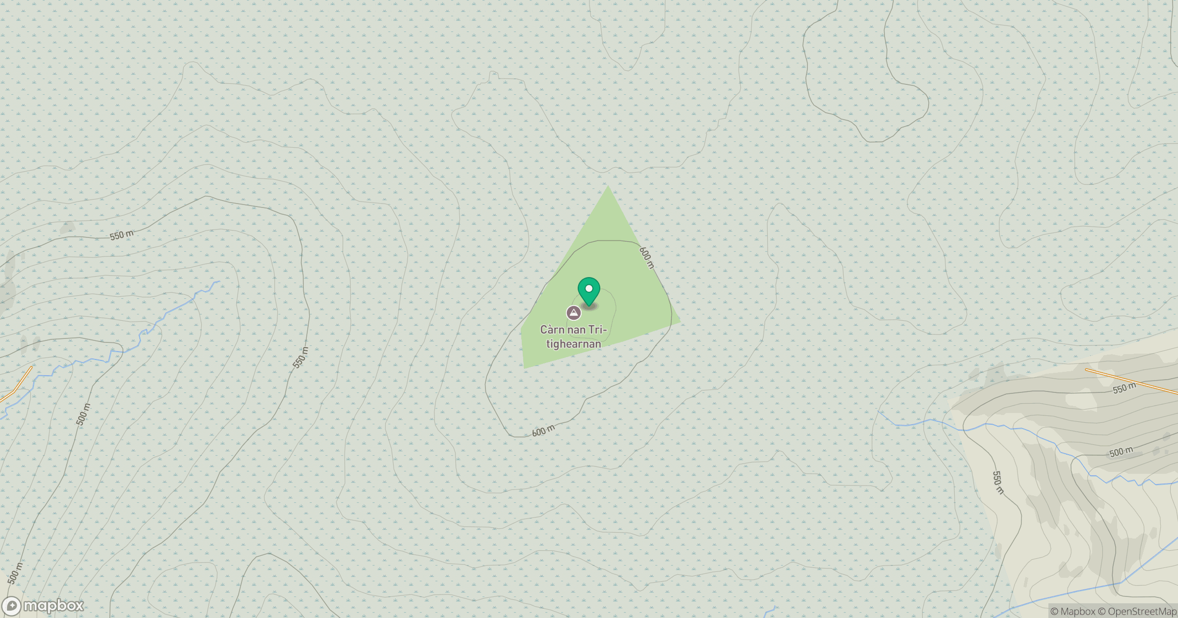
Grid reference: NH823390
View on OpenStreetMapOpens a map in a new tab, centred on the hill.
![Ben Macdui [Beinn Macduibh]](https://cdn.walkmates.com/gallery-images/e60cf32aeb394c3282fcdd14a63368f0.jpg)
No comments yet. Be the first.