

Peel Fell
Good walks are even better shared.
NY6299 : Peel Fell
Peter McDermott Photo source
Overview
Peel Fell
Peel Fell, standing at an impressive 605 meters, is a delightful gem tucked away in the Southern Uplands of Scotland. Known for its rugged beauty, this Marilyn offers both a satisfying hike and rewarding views, proving that sometimes the most unassuming hills pack the biggest punch.
Geology
Peel Fell is primarily composed of sedimentary rocks from the Devonian period. The ancient processes that shaped its current form are visible in the granite outcrops spotting the landscape. It’s like Mother Nature’s own jigsaw puzzle!
Access and Parking
Getting to Peel Fell is relatively easy. The nearest parking area is located in Kershopefoot, just off the B709 road. There’s plenty of room for cars, though you may have to share space with a few sheep on busy weekends. For those relying on public transport, the closest bus stop is in Kershopefoot, with services that might require a bit of patience and good timing. If you fancy a post-hike cuppa, head to Langholm, about 10 km away.
The Route
The recommended route is the Peel Fell Circular Walk, clocking in at 10.5 km with a moderate difficulty level. Starting from Kershopefoot, this trail takes you through charming woodlands and open heather moors. It’ll test your legs but reward your spirit!
Summit Features
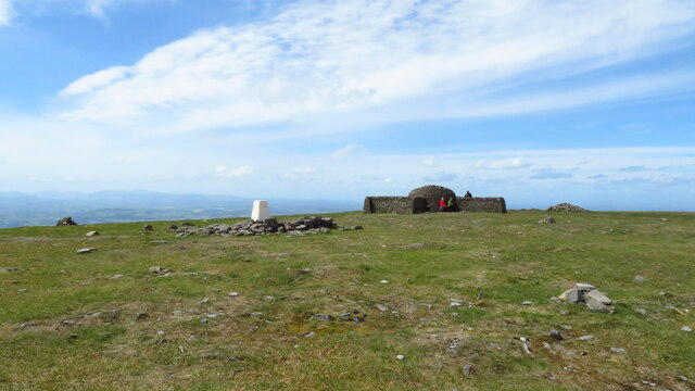
Once you reach the summit, you’re greeted by a sturdy stone cairn and a trig point—a perfect spot for a celebratory photo. Make sure to capture that triumphant smile (and be sure your buddy does too, no one believes you climbed a mountain without proof!)
Terrain Type
The terrain ranges from grassy slopes to rocky outcrops, interspersed with the cheeky bog that will challenge even the sturdiest of boots. Pro tip: wear your mud-ready shoes unless you truly believe in the therapeutic qualities of gloopy mud!
Views
From the summit, if the weather is cooperating, you’ll witness breathtaking views of the Scottish Borders and the Cheviot Hills. The sights are particularly glorious in spring and autumn, when the landscape turns vibrant and the skies are clearer.
Hazards
Keep in mind that weather can change quicker than you can say 'Let's go hiking!' The summit is exposed, so be prepared for windy surprises or sudden rain. Watch your footing, especially through boggy patches; the last thing you want is to become one with the mire!
Nearby Summits
If you’re feeling adventurous, consider tackling nearby summits like Kershopefoot (570 meters) and Penway Hill (620 meters). They might not match Peel Fell’s charm, but they’re fine companions on your hike.
Facilities
While you won’t find facilities on the mountain, Langholm has an array of cafes and shops to stock up on snacks or grab a warm drink post-adventure. Just remember, coffee counts as hydration too!
History
The name 'Peel' harkens back to Old English, meaning 'hill' or 'mountain,' while 'Fell' indicates its Scottish roots as a hill. This hill has been a landmark for many a shepherd and walker, guiding them through the rural Scottish terrain.
In conclusion, Peel Fell is waiting for you to lace up those walking boots and enjoy its natural splendour. Whether you seek solitude or stunning views, Peel Fell delivers in spades!
Happy hiking!
Explore routes near Peel Fell
Walks starting near this hill. Open a route to check its map, distance and full itinerary.
Kielder Skyspace and Observatory Forest Walk
View route
Bakethin Hide Wild Walk
View route
Kielder Forest - 50 Rocks of Northumberland inspired
View route
Lewisburn Inlet from Matthew’s Linn
View route
Route planning notes
These notes describe possible approaches. Check a route's map and access information when planning your walk.
Peel Fell Circular Walk
This circular route starts from the village of Kershopefoot and takes you through picturesque woodlands and open heather moors right to the summit of Peel Fell.
Make a day of it, together
Find someone to share the walk with, or organise a day out along a route you like.
Photo Gallery
View all Photo could not load
NY6299 : Jenny Storie's Stone and Deadwater Fell
James T M Towill
 Photo could not load
NY6299 : Jenny Storie's Stone
Les Hull
 Photo could not load
NY6299 : Misty crags near Jenny Storie's Stone
Les Hull
 Photo could not load
NY6299 : Peel Fell
Richard Webb
 Photo could not load
NY6299 : Peel Fell
Peter McDermott
 Photo could not load
NY6299 : A cairn on Peel Fell
James T M Towill
 Photo could not load
NY6299 : Cairn near Jenny Storie's Stone
Les Hull
 Photo could not load
NY6299 : Peel Fell cairn
David Brown
Hill facts and local notes
Classifications
Elevation
603m
1,977 ft
Prominence
195m
Coordinates
55.2902, -2.5906
NY625997
OS Map
80
Explorer: OL42W
At the Summit
The summit is marked by a substantial stone cairn and a trig point, offering a perfect backdrop for your summit selfies.
Terrain & Geology
Peel Fell is primarily composed of sedimentary rocks from the Devonian period, offering a glimpse into ancient geological processes. The terrain features granite outcrops that add to its rugged charm.
Views & Scenery
On a clear day, enjoy stunning vistas of the Scottish Borders and the Cheviot Hills, with the outlines of nearby peaks standing proud.
History & Heritage
Name Origin
The name 'Peel' is derived from an Old English word for 'hill' or 'mountain,' while 'Fell' indicates a hill or mountain in Scotland.
Historical Significance
Peel Fell has been a notable landmark for local shepherds and walkers for centuries, serving as a point of navigation in the rural landscape.
Getting There & Facilities
Parking
Parking is available at Kershopefoot, just off the B709 road. Ample space for cars, but it can fill up on nice weekends.
Public Transport
The nearest bus stop is in the village of Kershopefoot, but services are infrequent, so plan accordingly.
Nearby Facilities
While there are no facilities directly on the mountain, Langholm has several cafes, shops, and public toilets for your convenience.
Safety Information
Known Hazards
- Be wary of sudden weather changes; the summit can be quite exposed. Also, keep an eye out for the occasional bog, unless you're keen on 'mud wrestling.'
General Safety Tips
- Check weather conditions before setting out
- Carry appropriate clothing and equipment
- Let someone know your planned route
- Take a map, compass, and GPS device
- Carry emergency supplies: food, water, first aid kit, torch
Hills
Some common questions about the hills answered
Are there group walks up Peel Fell?
Many walkers use Walkmates to join or organise walks with others. You can check for group walks around Peel Fell through the maps
Are there other walkers around Peel Fell?
Activity varies by location and time, but Walkmates lets you see whether others have shared walks or shown interest in this area. Find other people through the walking friends search walking friends for Peel Fell search or of course create your own walk for Peel Fell
Can I organise a walk to Peel Fell?
Yes. If there aren’t any walks listed already, you can create a walk and make it available for others to join.
If you're signed up to Walkmates, you can create a walk to Peel Fell.
How do I find a walk up this hill?
There are often multiple ways to walk this hill, depending on experience and route preference. Walkmates helps you explore walks and routes that others have shared.
Can I suggest a new route up Peel Fell?
Yes. You can suggest or create routes to share with others. Walkmates focuses on the social side of walking, so routes are used to help people organise walks and explore areas together, rather than as detailed navigation tools or route libraries.
Other uses really appreciate knowledgeable walkers sharing their routes. Share your favourite route to Peel Fell here
The is an error or something incorrect about this hill. How do I let you know?
We always strive to keep the information on Walkmates as accurate as possible. If you find an error, please let us know through the contact form and we'll aim to correct it as quickly as possible
Community Discussion
Comments
Location
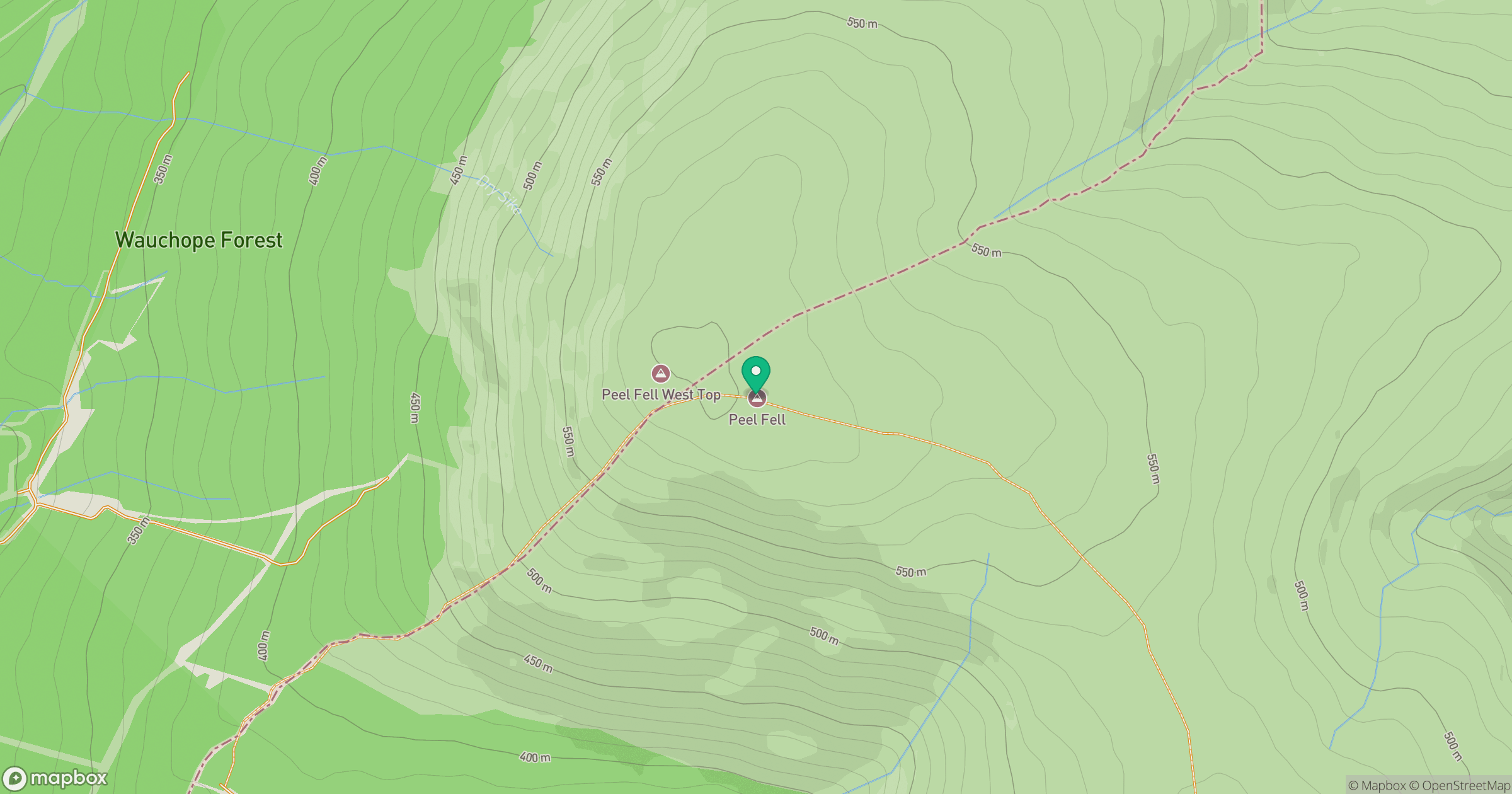
Grid reference: NY625997
View on OpenStreetMapOpens a map in a new tab, centred on the hill.
No comments yet. Be the first.