
Mynydd Mawr
Good walks are even better shared.
Overview
Mynydd Mawr
Mynydd Mawr, meaning 'Big Mountain', is an impressive peak located in the breathtaking Snowdonia National Park. Standing at 600 meters, it boasts not only great height but also stunning views that make the climb more than worthwhile.
Geology
The mountain is fascinating geologically, primarily comprised of volcanic rock such as andesite and basalt. Its rugged terrain is a testament to the volcanic activity that shaped this region millions of years ago. Don't be surprised if you come across some interesting rock formations along your hike!
Routes
One of the most popular routes begins in the quaint village of Bethlehem. This 9.5 km trek takes approximately 3.5 hours to complete and is rated moderate in difficulty, perfect for those looking for a rewarding day out.
Summit Features
At the summit, hikers are greeted by a sizable cairn and a trig point marking the highest point. The views from Mynydd Mawr are simply spectacular, offering a panoramic vista of the nearby peaks and valleys of Snowdonia.
Terrain
Expect rocky outcrops and grassy areas, accompanied by some fairly steep sections. It's a classic Welsh uphill experience – so tighten those laces!
Views
Your hard work will be visible in the form of stunning panoramas. From the summit, you can catch sight of the majestic Yr Wyddfa (Snowdon) and the picturesque Llanberis Pass, making every step worth it. Spring and Autumn are particularly celebrated for their delightful weather and breathtaking views.
Hazards
As always in the hills, keep an eye on the weather. It can change quicker than a sheep can jump, leading to fog and rain. Stay on marked paths to avoid those not-so-friendly boggy areas!
Nearby Summits
If you're looking to extend your adventure, Mynydd Drws-y-Coed and Moel Eilio are perfectly positioned for further exploration. Rinse and repeat, as they say!
Access
For access, there's a small parking area at the start of the Bethlehem route, accommodating about 10 vehicles. Public transport is available, with buses running from local towns like Caernarfon.
While there are no facilities directly on the mountain, local villages such as Bethlehem boast charming cafes and pubs, perfect for a well-deserved post-hike treat.
History
The meaning of 'Mynydd Mawr' is quite literal, referring to its status as the 'Big Mountain'. Historically, this peak has captured the imagination of local shepherds and is part of regional folklore.
Whether you are a seasoned hiker or a family on an adventure, Mynydd Mawr offers a remarkable day out in one of the UK’s most inspiring national parks. Happy trekking!
Explore routes near Mynydd Mawr
Public walks starting within 80 km of this hill. Nearby does not mean a route reaches the summit; check its map and access before setting out.
Llangollen to Horseshoe Falls: Canal Towpath from Market Street
View route
Oswestry Walk with Men Walking & Talking
View route
World’s End and back
View route
Welshpool to Sweeps Bridge: Montgomery Canal and Belan Locks
View route
Route planning notes
These notes describe possible approaches, not verified navigable routes or permission to cross land. Check current paths, local access rules and conditions before setting out.
Bethlehem to Mynydd Mawr
A wonderful route starting from the charming village of Bethlehem, leading hikers through lush valleys and up to the summit of Mynydd Mawr.
Make a day of it, together
Find someone to share the walk with, or organise a day out along a route you like.
Hill facts and local notes
Classifications
Elevation
534m
1,752 ft
Prominence
104m
Coordinates
52.8481, -3.2891
SJ132286
OS Map
125
Explorer: 255
At the Summit
The summit features a large cairn and stunning views across the Snowdonia range, with a trig point marking the highest point.
Terrain & Geology
Mynydd Mawr is primarily composed of volcanic rock, with significant deposits of andesite and basalt. The rugged terrain reveals the geological history shaped by volcanic activity millions of years ago.
Views & Scenery
From the summit, hikers can enjoy panoramic views of Snowdonia, with notable sights including Yr Wyddfa (Snowdon) and the Llanberis Pass.
History & Heritage
Name Origin
The name 'Mynydd Mawr' translates to 'Big Mountain' in English, a fitting description for this prominent peak.
Historical Significance
Historically, Mynydd Mawr has been a point of interest for local shepherds and is featured in Welsh folklore, often celebrated in stories of the countryside.
Getting There & Facilities
Check current local access restrictions, parking rules and transport timetables before travelling. These notes do not confirm public access to the summit.
Parking
There's a small parking area at the start of the Bethlehem route, which accommodates around 10 vehicles. Arrive early to secure a spot.
Public Transport
Buses run from local towns such as Caernarfon to Bethlehem, providing access for those relying on public transport.
Nearby Facilities
There are no facilities on the mountain itself, but local villages like Bethlehem offer cafes and pubs for post-hike refreshment.
Safety Information
Known Hazards
- Be wary of sudden weather changes, which can lead to fog and rain. Stick to marked paths to avoid boggy areas.
General Safety Tips
- Check weather conditions before setting out
- Carry appropriate clothing and equipment
- Let someone know your planned route
- Take a map, compass, and GPS device
- Carry emergency supplies: food, water, first aid kit, torch
Hills
Some common questions about the hills answered
Are there group walks up Mynydd Mawr?
Many walkers use Walkmates to join or organise walks with others. You can check for group walks around Mynydd Mawr through the maps
Are there other walkers around Mynydd Mawr?
Activity varies by location and time, but Walkmates lets you see whether others have shared walks or shown interest in this area. Find other people through the walking friends search walking friends for Mynydd Mawr search or of course create your own walk for Mynydd Mawr
Can I organise a walk to Mynydd Mawr?
Yes. If there aren’t any walks listed already, you can create a walk and make it available for others to join.
If you're signed up to Walkmates, you can create a walk to Mynydd Mawr.
How do I find a walk up this hill?
There are often multiple ways to walk this hill, depending on experience and route preference. Walkmates helps you explore walks and routes that others have shared.
Can I suggest a new route up Mynydd Mawr?
Yes. You can suggest or create routes to share with others. Walkmates focuses on the social side of walking, so routes are used to help people organise walks and explore areas together, rather than as detailed navigation tools or route libraries.
Other uses really appreciate knowledgeable walkers sharing their routes. Share your favourite route to Mynydd Mawr here
The is an error or something incorrect about this hill. How do I let you know?
We always strive to keep the information on Walkmates as accurate as possible. If you find an error, please let us know through the contact form and we'll aim to correct it as quickly as possible
Community Discussion
Comments
Location
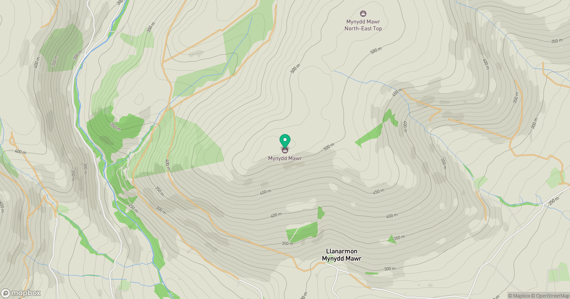
Grid reference: SJ132286
View on OpenStreetMapOpens a map in a new tab, centred on the hill.
Hills within 30 km
Straight-line distance, not a walking route or confirmation of access.
No comments yet. Be the first.