

Mynydd Llwyn-gwern
Good walks are even better shared.
SH7604 : Gate on the path
John Lucas Photo source
Overview
Mynydd Llwyn-gwern: A Hiker's Delight
Nestled within the breathtaking Brecon Beacons National Park, Mynydd Llwyn-gwern offers a perfect blend of moderate hiking challenges and stunning scenery. With an elevation of 490 meters, it stands proud among its peers while being classified as a Marilyn.
Geology
The mountain is primarily composed of Old Red Sandstone. This ancient stone tells tales of prehistoric waterways and sediment systems through its vibrant colour and texture. The fossil-rich strata spark intrigue, perfect for geology buffs and those who enjoy peering into the Earth’s history.
Routes
Cwm Llwyn-gwern Route
This popular route is a scenic gem, leading hikers through lush valleys and meandering uphill to the summit. At 6.5 km in length, it takes about 3.5 hours to hike, depending on your pace and the time spent soaking in the views. The path is well-marked, making navigation a breeze, even if your reading glasses are at home!
Summit Features
Upon reaching the summit, you’ll encounter a modest cairn and the remnants of a trig point. These features not only highlight the attainment of your goal but offer an inviting backdrop for that all-important summit selfie.
Terrain
The terrain on Mynydd Llwyn-gwern is a delightful mix of grassy patches and rocky outcrops. Expect to feel the thrill of climbing, tempered with the joy of solid ground beneath your feet—no tightrope walking necessary!
Views
From the pinnacle, breathtaking views await. The central Brecon Beacons, expansive Usk Valley, and if luck favours you, the majestic Black Mountains stretch out before your eyes. For the best visual experience, visit in spring or autumn when nature shows off its finest colours.
Hazards
Despite the mountain's welcoming demeanor, be wary of sudden changes in the weather and slippery paths, particularly after rainfall. It's always wise to dress in layers and keep your eyes peeled for that sneaky cloud cover!
Nearby Summits
While you’re exploring Mynydd Llwyn-gwern, you might fancy a detour to nearby summits like Mynydd Fforest (500 m) or Mynydd Llangorse (570 m), both offering unique views and atmospheres.
Access
Nearest Parking
There’s a handy little car park right at the start of the Cwm Llwyn-gwern track.
Public Transport
Brecon serves as your launching pad with bus services heading to the village of Sennybridge.
Nearest Town
Brecon is your best bet, around 10 miles south, brimming with cafes and treats aplenty.
Facilities
Once your adventure is complete, enjoy local cafes and toilets in Brecon, perfect for recharging your batteries after a day of invigorating hiking!
History
The name Mynydd Llwyn-gwern translates beautifully to 'Hill of the willow grove', reflecting the scenic and natural legacy of the landscape. Historically, it has been woven into the local folklore and served as a part of ancient trade routes.
In conclusion, Mynydd Llwyn-gwern offers an accessible yet rewarding hiking experience, complete with stunning views and a dash of history. So pack your bags, grab your boots, and get ready to enjoy everything this charming hill has to offer!
Happy hiking!
Explore routes near Mynydd Llwyn-gwern
Walks starting near this hill. Open a route to check its map, distance and full itinerary.
Cadair Idris - Pony Path
View route
Waun-oer, Maesglase and Cribin Fawr guided mountain walk
View route
Mawddach Trail: Penmaenpool to Dolgellau Riverside Return
View route
Mawddach Trail: Penmaenpool to Arthog Estuary Return
View route
Route planning notes
These notes describe possible approaches. Check a route's map and access information when planning your walk.
Cwm Llwyn-gwern Route
A popular and scenic route that takes hikers through lush valleys and up to the summit via well-trodden paths.
Make a day of it, together
Find someone to share the walk with, or organise a day out along a route you like.
Photo Gallery
View all Photo could not load
SH7604 : Gate on the path
John Lucas
 Photo could not load
SH7604 : Community turbine
Rudi Winter
 Photo could not load
SH7604 : Turbine base
Rudi Winter
 Photo could not load
SH7604 : Distant view of Cwm Cau from Mynydd Llwyn-Gwern
Rudi Winter
 Photo could not load
SH7604 : Along the forest boundary
Rudi Winter
Hill facts and local notes
Classifications
Elevation
277m
909 ft
Prominence
34m
Coordinates
52.6249, -3.8236
SH766045
OS Map
135
Explorer: OL23W 215W
At the Summit
The summit boasts a modest cairn and the remains of a trig point, offering a perfect photo opportunity to capture your hiking triumph.
Terrain & Geology
The mountain is primarily composed of Old Red Sandstone, recognized for its distinctive reddish hue and fossil-rich deposits. The terrain features interesting sedimentary structures that tell tales of ancient river systems.
Views & Scenery
From the summit, you can enjoy breathtaking views of the central Brecon Beacons, the sprawling Usk Valley, and on a clear day, even as far as the Black Mountains.
History & Heritage
Name Origin
Mynydd Llwyn-gwern translates to 'Hill of the willow grove', reflecting the rich natural heritage of the area.
Historical Significance
Historically, the mountain has been a part of local folklore and was frequented by ancient trade routes.
Getting There & Facilities
Parking
Parking is available at the beginning of the Cwm Llwyn-gwern track, where you'll find a small car park suitable for several vehicles.
Public Transport
The nearest bus service runs from Brecon to the village of Sennybridge, from where you can start your hike.
Nearby Facilities
While the mountain itself is rugged and remote, Brecon offers local cafes, restaurants, and public toilets for pre- or post-hike necessities.
Safety Information
Known Hazards
- Be cautious of sudden weather changes typical of the Brecon Beacons, as well as slippery slopes after rain.
General Safety Tips
- Check weather conditions before setting out
- Carry appropriate clothing and equipment
- Let someone know your planned route
- Take a map, compass, and GPS device
- Carry emergency supplies: food, water, first aid kit, torch
Hills
Some common questions about the hills answered
Are there group walks up Mynydd Llwyn-gwern?
Many walkers use Walkmates to join or organise walks with others. You can check for group walks around Mynydd Llwyn-gwern through the maps
Are there other walkers around Mynydd Llwyn-gwern?
Activity varies by location and time, but Walkmates lets you see whether others have shared walks or shown interest in this area. Find other people through the walking friends search walking friends for Mynydd Llwyn-gwern search or of course create your own walk for Mynydd Llwyn-gwern
Can I organise a walk to Mynydd Llwyn-gwern?
Yes. If there aren’t any walks listed already, you can create a walk and make it available for others to join.
If you're signed up to Walkmates, you can create a walk to Mynydd Llwyn-gwern.
How do I find a walk up this hill?
There are often multiple ways to walk this hill, depending on experience and route preference. Walkmates helps you explore walks and routes that others have shared.
Can I suggest a new route up Mynydd Llwyn-gwern?
Yes. You can suggest or create routes to share with others. Walkmates focuses on the social side of walking, so routes are used to help people organise walks and explore areas together, rather than as detailed navigation tools or route libraries.
Other uses really appreciate knowledgeable walkers sharing their routes. Share your favourite route to Mynydd Llwyn-gwern here
The is an error or something incorrect about this hill. How do I let you know?
We always strive to keep the information on Walkmates as accurate as possible. If you find an error, please let us know through the contact form and we'll aim to correct it as quickly as possible
Community Discussion
Comments
Location
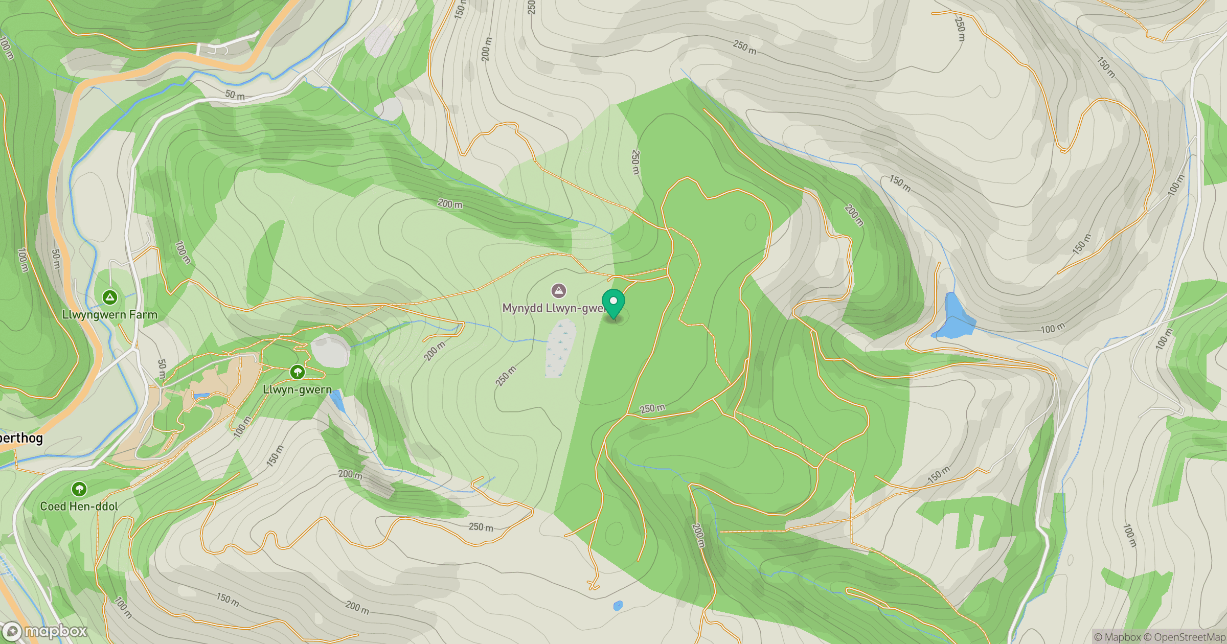
Grid reference: SH766045
View on OpenStreetMapOpens a map in a new tab, centred on the hill.
Nearby Hills
Cadair Idris - Penygadair
893m
Pumlumon Fawr [Plynlimon]
753m
Y Garn
629m
Aran Fawddwy
906m
Rhinog Fawr
721m
No comments yet. Be the first.