
Ceiswyn
Good walks are even better shared.
Overview
Ceiswyn: A Hidden Gem in the Brecon Beacons
Nestled in the heart of the Brecon Beacons, Ceiswyn may not be the tallest mountain in the area, but it certainly packs a punch with its stunning landscapes and versatile hiking routes. Standing at an elevation of 623 meters, it's officially classified as a Marilyn, meaning it has a prominence of over 150 meters – a fact that might impress your hiking mates, if you ever need to debate the merits of lesser-known peaks!
Geology
Ceiswyn is primarily composed of Old Red Sandstone, a vivid reminder of the area's ancient geological history. As you ascend, keep an eye out for intriguing sedimentary patterns that reveal the story of earth's artistic flair over millions of years.
Routes
The most popular routes to summit Ceiswyn start from Cwm Llwch and Penderyn, both offering unique perspectives on the beauty of the Brecon Beacons.
Cwm Llwch Route
This moderate route stretches approximately 8.5 km and takes about 3.5 hours to complete. Adventurers will weave through lush heaths and vibrant wildlife, all while gradually gaining elevation to the summit.
Penderyn Trail
For those seeking an easier option, the Penderyn Trail is a delightful 7.2 km walk that takes around 3 hours. Perfect for families, this route allows for leisurely hiking while soaking in the views at an unhurried pace.
Summit Features
Upon reaching the summit, hikers are greeted by a quaint cairn and a stone shelter—ideal for a quick rest and some photo opportunities with the stunning backdrop in view.
Terrain Type
Expect grassy slopes and rocky outcrops as you trek up the mountain. Just remember: sheep have the right of way, especially if they're taking a sunbath!
Views
The summit vista of Ceiswyn is nothing short of spectacular. On clear days, trekkers can enjoy an uninterrupted 360-degree view of the surrounding peaks, including Pen y Fan and Corn Du. Late spring and autumn are the best seasons for these awe-inspiring sights.
Hazards
Although Ceiswyn is approachable for most hikers, be cautious during wet weather as trails can become slippery. Ensure you're prepared for swiftly changing conditions; they can be as unpredictable as a child's taste in food!
Nearby Summits
Hiking enthusiasts should not miss the chance to explore other peaks in the region, such as Pen y Fan and Corn Du, both offering further challenges and breathtaking views.
Access
Accessing Ceiswyn is a breeze! The nearest car park is at Cwm Llwch, making it simple to start your adventure. Plus, Brecon is just a stone's throw away for a quick coffee or pub lunch.
Facilities
While facilities on the mountain are sparse, the town of Brecon provides plenty of options for refreshments and a pit stop before or after your hike.
History
The name 'Ceiswyn' is derived from Welsh, suggesting a beautiful and delicate landscape. Rich in cultural folklore, this mountain whispers tales of mythical creatures, adding to its allure.
With all its splendor and charm, Ceiswyn offers avid hikers a delightful experience steeped in natural beauty and rich history—a perfect escape from the daily grind.
Happy hiking!
Explore routes near Ceiswyn
Public walks starting within 80 km of this hill. Nearby does not mean a route reaches the summit; check its map and access before setting out.
Cadair Idris - Pony Path
View route
Mawddach Trail: Dolgellau to Barmouth
View route
Mawddach Trail: Penmaenpool to Dolgellau Riverside Return
View route
Mawddach Trail: Penmaenpool to Arthog Estuary Return
View route
Route planning notes
These notes describe possible approaches, not verified navigable routes or permission to cross land. Check current paths, local access rules and conditions before setting out.
Cwm Llwch Route
This route begins at the Cwm Llwch car park and meanders through stunning heaths before ascending to the summit, rewarding hikers with breathtaking views.
Penderyn Trail
An enjoyable trail starting from the village of Penderyn, this route involves a gentle ascent and is amplified by spectacular vistas along the way.
Make a day of it, together
Find someone to share the walk with, or organise a day out along a route you like.
Hill facts and local notes
Classifications
Elevation
545m
1,788 ft
Prominence
145m
Coordinates
52.6813, -3.8574
SH745109
OS Map
124
Explorer: OL23W
At the Summit
The summit features a prominent cairn, with a small stone shelter that offers a welcome break from the winds. There's also a stunning panoramic view which could almost make a mountain goat shed a tear of joy.
Terrain & Geology
Ceiswyn is primarily composed of Old Red Sandstone, known for its characteristic reddish hues. The area features some interesting sedimentary rocks, formed over millions of years, and the erosion patterns can reveal fascinating geological features.
Views & Scenery
From the summit, you can see the majestic peaks of the Brecon Beacons, including Pen y Fan and Corn Du. On a clear day, the sights extend to the Black Mountains and beyond.
History & Heritage
Name Origin
The name 'Ceiswyn' is believed to derive from the Welsh words meaning 'subtle' or 'delicate', perhaps referencing the mountain's gentle slopes.
Historical Significance
Ceiswyn holds cultural significance in local folklore as a sacred site where various tales of mythical creatures are often told, making it a real crowd-pleaser for story lovers.
Getting There & Facilities
Check current local access restrictions, parking rules and transport timetables before travelling. These notes do not confirm public access to the summit.
Parking
The nearest parking area is Cwm Llwch Car Park (SH 949 195), which provides ample space for vehicles and easy access to the starting trails.
Public Transport
Public transport options include regular bus services to nearby towns such as Brecon and Merthyr Tydfil, followed by a short hike to the start of the routes.
Nearby Facilities
While there are no facilities directly on the mountain, Brecon boasts a range of cafes, restaurants, and toilets to cater to weary walkers before and after their expeditions.
Safety Information
Known Hazards
- During wet weather, the trails can be slippery, and visibility may decrease rapidly. Remember: mountain weather changes quicker than a cat on a hot tin roof!
General Safety Tips
- Check weather conditions before setting out
- Carry appropriate clothing and equipment
- Let someone know your planned route
- Take a map, compass, and GPS device
- Carry emergency supplies: food, water, first aid kit, torch
Hills
Some common questions about the hills answered
Are there group walks up Ceiswyn?
Many walkers use Walkmates to join or organise walks with others. You can check for group walks around Ceiswyn through the maps
Are there other walkers around Ceiswyn?
Activity varies by location and time, but Walkmates lets you see whether others have shared walks or shown interest in this area. Find other people through the walking friends search walking friends for Ceiswyn search or of course create your own walk for Ceiswyn
Can I organise a walk to Ceiswyn?
Yes. If there aren’t any walks listed already, you can create a walk and make it available for others to join.
If you're signed up to Walkmates, you can create a walk to Ceiswyn.
How do I find a walk up this hill?
There are often multiple ways to walk this hill, depending on experience and route preference. Walkmates helps you explore walks and routes that others have shared.
Can I suggest a new route up Ceiswyn?
Yes. You can suggest or create routes to share with others. Walkmates focuses on the social side of walking, so routes are used to help people organise walks and explore areas together, rather than as detailed navigation tools or route libraries.
Other uses really appreciate knowledgeable walkers sharing their routes. Share your favourite route to Ceiswyn here
The is an error or something incorrect about this hill. How do I let you know?
We always strive to keep the information on Walkmates as accurate as possible. If you find an error, please let us know through the contact form and we'll aim to correct it as quickly as possible
Community Discussion
Comments
Location
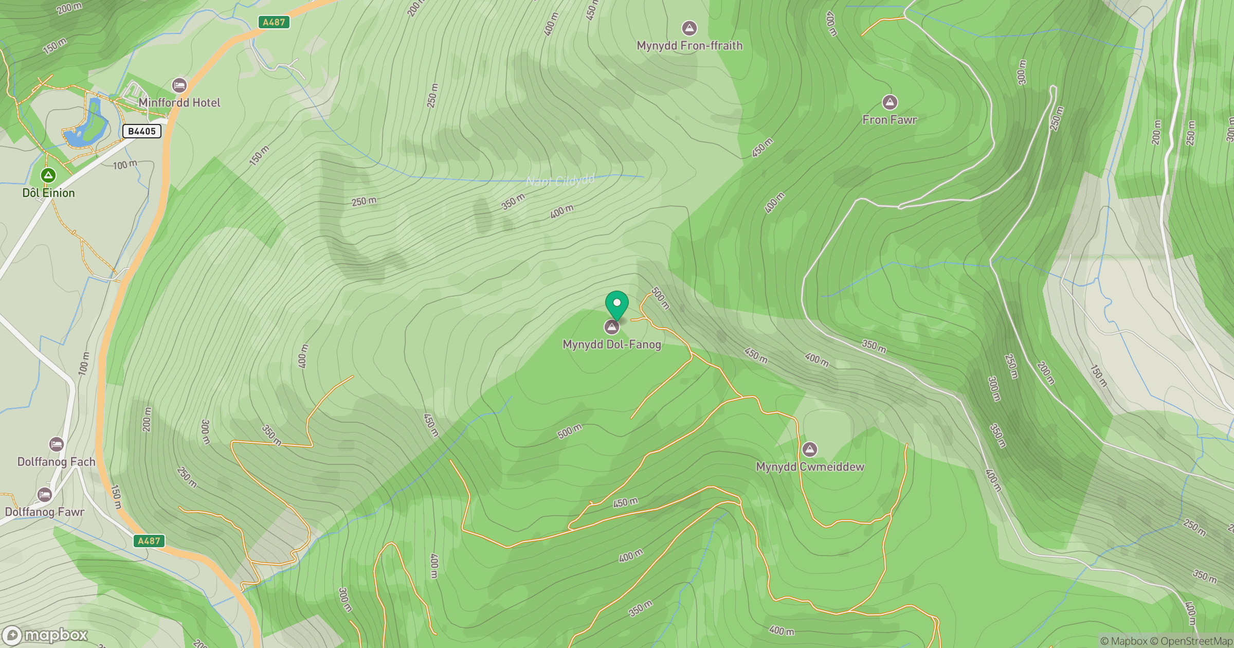
Grid reference: SH745109
View on OpenStreetMapOpens a map in a new tab, centred on the hill.
Hills within 30 km
Straight-line distance, not a walking route or confirmation of access.
Cadair Idris - Penygadair
893m
Y Garn
629m
Aran Fawddwy
906m
Rhinog Fawr
721m
Pumlumon Fawr [Plynlimon]
753m
No comments yet. Be the first.