

Meall na Teanga
Good walks are even better shared.
NN2292 : Summit of Meall na Teanga
Russel Wills Photo source
Overview
Meall na Teanga
Meall na Teanga, a Marilyn in the heart of the Scottish Highlands, rises to a proud elevation of 579 meters. Its relatively modest stature might make you think, 'Oh, it’s just a hill!', but don't let that fool you; the views from the top are nothing short of spectacular.
Getting There
To reach Meall na Teanga, start from the Ben More trailhead. The journey unfolds over approximately 8 km of moderate hiking, winding through lush, grassy moorlands and rocky paths that demand a bit of attention, especially near the summit. If you’re lucky, you might spot the odd deer or hare—don't forget to wave!
Terrain and Environment
The terrain is grassy but can be deceptively boggy. It’s a good idea to pack those wellies or sturdy walking boots if you want to keep your socks dry. The geology here is fascinating, showcasing granite and schist as you ascend. Not typical dinner conversation, but worth mentioning!
Views and Experience
Once you reach the summit, you’ll be greeted by a delightful stone cairn and breathtaking panoramic views. Be sure to snap a few photos as the backdrop is Instagram gold. The best time for enjoying these vistas is late spring to early autumn when the weather is more cooperative.
Hazards to Keep in Mind
While trekking up, keep an eye on the fickle Scottish weather—it can turn faster than a squirrel on a sugar rush. Also, watch out for the muddy sections; you wouldn't want to become a mud sculpture in the great outdoors!
Nearby Attractions
Nearby, the towering Ben More stands watch, calling to adventurers with its own set of challenges. The rugged landscape of the highlands is full of surprises, promising more hikes to fill your boots with mud.
Conclusion
So, grab your backpacks, lace up those boots, and set off to explore Meall na Teanga. Great views await you, and remember, the journey is just as valuable as the destination—enjoy!
Last Updated
This information is up-to-date as of 2023-10-10.
Explore routes near Meall na Teanga
Walks starting near this hill. Open a route to check its map, distance and full itinerary.
Banavie to Glen Loy Aqueduct: Neptune’s Staircase Canal Towpath
View route
Ben Nevis via Mountain Path
View route
Fort Augustus to Kytra Lock: Caledonian Canal Towpath
View route
Glen Affric: Coire Loch Woodland Trail
View route
Route planning notes
These notes describe possible approaches. Check a route's map and access information when planning your walk.
Ben More approach
A straightforward route starting from the Ben More trailhead that takes you through lush moorlands before ascending to the summit.
Make a day of it, together
Find someone to share the walk with, or organise a day out along a route you like.
Photo Gallery
View all Photo could not load
NN2292 : Summit of Meall na Teanga
Russel Wills
 Photo could not load
NN2192 : Path below the summit of Meall na Teanga
John Allan
 Photo could not load
NN2292 : Meall na Teanga : Munro No 275
Graham Ellis
 Photo could not load
NN2292 : on the summit of Meall na Teanga
bill copland
 Photo could not load
NN2292 : Summit of Meall na Teanga
trevor willis
 Photo could not load
NN2292 : Summit of Meall na Teanga
John Allan
 Photo could not load
NN2292 : Meall na Teanga
Richard Webb
 Photo could not load
NN2292 : Summit, Meall na Teanga
Chris Eilbeck
 Photo could not load
NN2292 : Summit of Meall na Teanga
Tim Glover

NN2292 : Summit cairn on Meall na Teanga - View to Meall Coire Lochain
Colin Park
Hill facts and local notes
Classifications
Elevation
917m
3,008 ft
Prominence
306m
Coordinates
56.9890, -4.9309
NN220924
OS Map
34
Explorer: 400
At the Summit
The summit features a stone cairn, which offers a perfect spot for a photo, albeit a windy one! There is also a panoramic view that draws you in like moth to a flame.
Terrain & Geology
The area primarily consists of granite and schist, sedimentary rocks that have been uplifted over millennia. The landscape displays typical glacial features, including U-shaped valleys carved by ancient ice flows.
Views & Scenery
From the summit, you can enjoy sweeping views of the surrounding highlands, including Loch Awe and the rugged peaks of nearby mountains like Ben More.
History & Heritage
Name Origin
Meall na Teanga translates to 'Hill of the Tongue', perhaps a reminder of how you might be left tongue-tied by the stunning vistas!
Historical Significance
The mountain forms part of the traditional territory associated with the MacGregor clan and preserves the cultural heritage of the highlands.
Getting There & Facilities
Parking
There is a small car park at the Ben More trailhead off the A85, which usually fills up quickly, so arrive early!
Public Transport
The nearest bus service stops in the village of Crianlarich, from where it is a 10 km walk to the trailhead.
Nearby Facilities
Crianlarich has a few cafes and shops, as well as public toilets near the train station for a quick pit-stop before hitting the trails.
Safety Information
Known Hazards
- Potential for sudden weather changes, muddy and slippery paths, and hidden rocks; always keep an eye on the forecast and your footing!
General Safety Tips
- Check weather conditions before setting out
- Carry appropriate clothing and equipment
- Let someone know your planned route
- Take a map, compass, and GPS device
- Carry emergency supplies: food, water, first aid kit, torch
Hills
Some common questions about the hills answered
Are there group walks up Meall na Teanga?
Many walkers use Walkmates to join or organise walks with others. You can check for group walks around Meall na Teanga through the maps
Are there other walkers around Meall na Teanga?
Activity varies by location and time, but Walkmates lets you see whether others have shared walks or shown interest in this area. Find other people through the walking friends search walking friends for Meall na Teanga search or of course create your own walk for Meall na Teanga
Can I organise a walk to Meall na Teanga?
Yes. If there aren’t any walks listed already, you can create a walk and make it available for others to join.
If you're signed up to Walkmates, you can create a walk to Meall na Teanga.
How do I find a walk up this hill?
There are often multiple ways to walk this hill, depending on experience and route preference. Walkmates helps you explore walks and routes that others have shared.
Can I suggest a new route up Meall na Teanga?
Yes. You can suggest or create routes to share with others. Walkmates focuses on the social side of walking, so routes are used to help people organise walks and explore areas together, rather than as detailed navigation tools or route libraries.
Other uses really appreciate knowledgeable walkers sharing their routes. Share your favourite route to Meall na Teanga here
The is an error or something incorrect about this hill. How do I let you know?
We always strive to keep the information on Walkmates as accurate as possible. If you find an error, please let us know through the contact form and we'll aim to correct it as quickly as possible
Community Discussion
Comments
Location
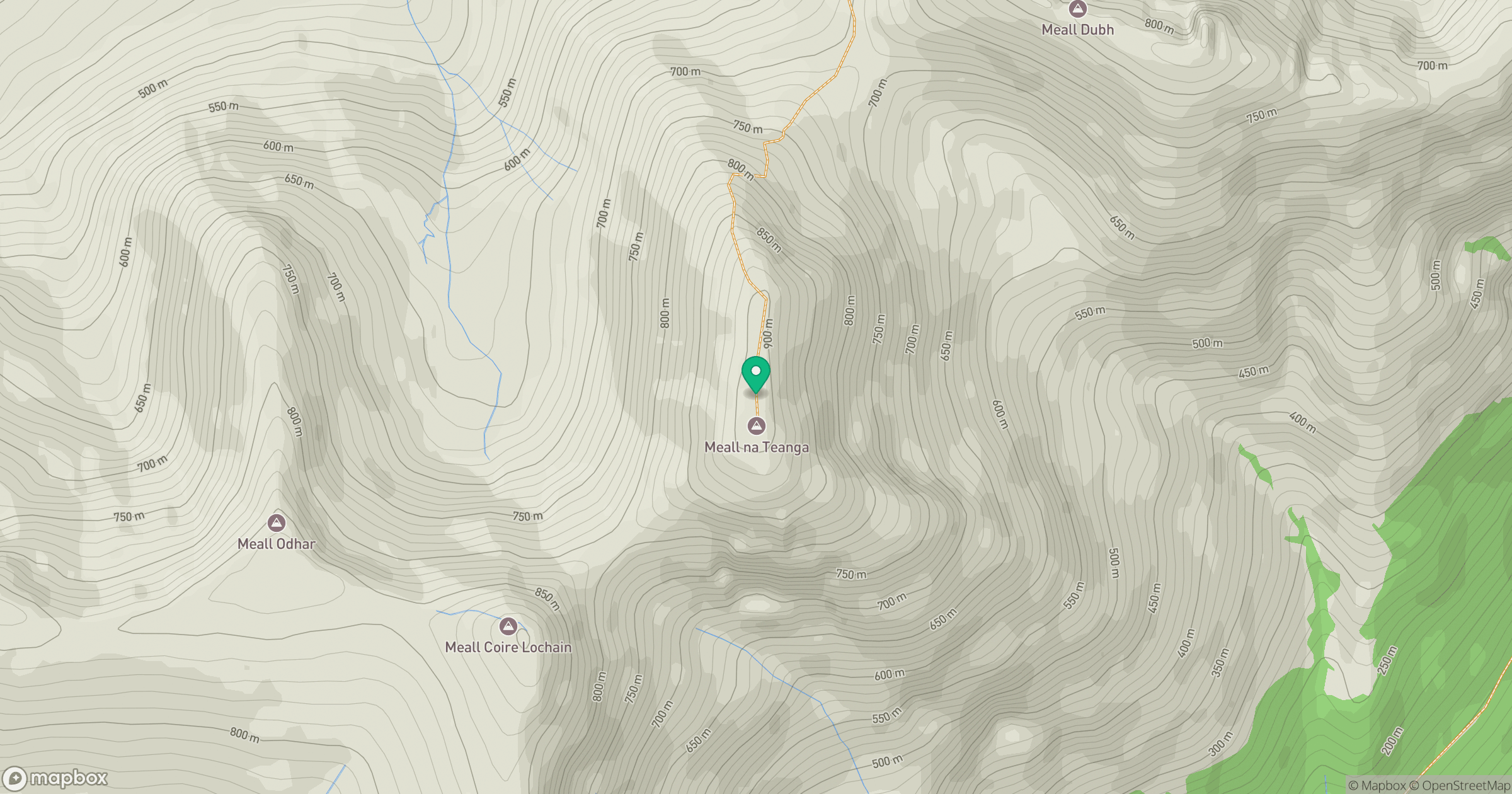
Grid reference: NN220924
View on OpenStreetMapOpens a map in a new tab, centred on the hill.
Nearby Hills
Aonach Mor
1,220m
Stob Choire Claurigh
1,177m
Aonach Beag
1,234m
Carn Mor Dearg
1,221m
Stob Ban
977m
No comments yet. Be the first.