

Meall na h-Eilde
Good walks are even better shared.
NN1894 : Snowfields high on the north side of Meall na h-Eilde
Richard Law Photo source
Overview
Meall na h-Eilde
Introduction
Nestled in the heart of the Scottish Highlands, Meall na h-Eilde rises to an elevation of 743 meters, offering stunning views and a delightful challenge for hikers. This Marilyn, with its gentle prominence, provides a fantastic opportunity to experience the wild beauty of Scotland.
Geology
The underlying rock formations predominantly consist of granite and schist, characteristics of the Highland landscape. These geological formations have shaped the various ridges and slopes we traverse, telling a story of ancient upheavals and tranquil landscapes.
Routes
The most popular route begins from Glen Etive, where adventurers can soak in the stunning scenery before tackling the ascent. It's about 10 km long and will take around 4 hours, making it a pleasant day out.
Summit Features
Upon reaching the summit, hikers are greeted by a modest cairn, a worthy landmark that begs for a photograph. The panoramic views can be simply breathtaking, offering the perfect backdrop for some celebratory snacks. Just be careful not to drop your sandwich—especially if it’s a bacon roll!
Terrain
Expect a nice mix of terrain types. You'll enjoy grassy slopes that beckon you up, rocky outcrops to navigate, and the occasional boggy patch that keeps you on your toes.
Views
From the summit, the views are nothing short of spectacular. You'll find yourself gazing at Buachaille Etive Mòr and the serene Loch Etive, making it well worth the climb. Spring and autumn are particularly golden times for stunning vistas, with vibrant colours and often clearer skies.
Hazards
As with any Highlands hike, expect the unexpected! Sudden weather changes can occur, so be aware. Also, those wet and muddy paths can turn treacherous, urging hikers to tread carefully.
Nearby Summits
Nearby towering giants such as Buachaille Etive Mòr and Stob na Broige can easily be included in your adventure if you're feeling ambitious!
Access
Glen Etive offers parking at the start of the trail, but be warned—it's small and can get crowded. If you’re left high and dry for parking, public transport options are available, albeit with a bit of a wait between services. Dalness is the closest town you can aim for if you run short on snacks or fancy a coffee!【/br】
Facilities
Facilities in the area are sparse but there’s a quaint café in Dalness where you can grab a bite post-hike. Basic toilets are available at the car park, so plan accordingly!
Conclusion
Meall na h-Eilde is not just a mountain; it offers a slice of Highland magic for both seasoned climbers and budding enthusiasts. So lace up your boots, grab a friend, and make memories that will last longer than the path’s boggy sections!
Explore routes near Meall na h-Eilde
Walks starting near this hill. Open a route to check its map, distance and full itinerary.
Banavie to Glen Loy Aqueduct: Neptune’s Staircase Canal Towpath
View route
Ben Nevis via Mountain Path
View route
Fort Augustus to Kytra Lock: Caledonian Canal Towpath
View route
Glen Affric: Coire Loch Woodland Trail
View route
Route planning notes
These notes describe possible approaches. Check a route's map and access information when planning your walk.
From Glen Etive
A well-trodden path starting from the scenic Glen Etive, leading through picturesque moorland before a steeper ascent to the summit.
Make a day of it, together
Find someone to share the walk with, or organise a day out along a route you like.
Photo Gallery
View all Photo could not load
NN1894 : Snowfields high on the north side of Meall na h-Eilde
Richard Law
 Photo could not load
NN1894 : Old fence line on Meall na h-Eilde
Steven Brown
 Photo could not load
NN1894 : Summit cairn - Meall na h-Eilde
Richard Law
 Photo could not load
NN1894 : Meall na h-Eilde
John Horner
 Photo could not load
NN1894 : Meall na h-Eilde
Raibeart MacAoidh
Hill facts and local notes
Classifications
Elevation
837m
2,747 ft
Prominence
450m
Coordinates
57.0070, -4.9896
NN185946
OS Map
34
Explorer: 399 400
At the Summit
The summit features a modest but notable cairn, offering a perfect spot for well-deserved photographs and a snack. There's also a panoramic view that might just take your breath away—hopefully not literally!
Terrain & Geology
Predominantly composed of granite and schist, typical of the Highlands, with some stunning outcrops providing a history of dramatic geological forces at play.
Views & Scenery
From the summit, you can see the striking peaks of the surrounding mountains, including Buachaille Etive Mòr, as well as the tranquil waters of Loch Etive.
History & Heritage
Name Origin
The name 'Meall na h-Eilde' translates roughly to 'Hill of the Swans' in Gaelic, possibly linked to the grace of swans that once frequented the waters of Loch Etive.
Historical Significance
This mountain, like many in the Scottish Highlands, has historical significance for both hikers and locals, known for its scenic beauty and as a significant climbing challenge.
Getting There & Facilities
Parking
There is parking available at the start of the Glen Etive road, where there's a small car park that can get busy during weekends.
Public Transport
Regular bus services run from nearby towns such as Ballachulish to the Glen Etive area, but check the timetable as they can be infrequent.
Nearby Facilities
Facilities are limited in the area; however, a charming café in Dalness serves refreshments and hot drinks for weary hikers. Toilets are available at the car park but may be basic.
Safety Information
Known Hazards
- Beware of sudden weather changes typical of the Highlands, as well as wet and muddy paths which can become slippery.
General Safety Tips
- Check weather conditions before setting out
- Carry appropriate clothing and equipment
- Let someone know your planned route
- Take a map, compass, and GPS device
- Carry emergency supplies: food, water, first aid kit, torch
Hills
Some common questions about the hills answered
Are there group walks up Meall na h-Eilde?
Many walkers use Walkmates to join or organise walks with others. You can check for group walks around Meall na h-Eilde through the maps
Are there other walkers around Meall na h-Eilde?
Activity varies by location and time, but Walkmates lets you see whether others have shared walks or shown interest in this area. Find other people through the walking friends search walking friends for Meall na h-Eilde search or of course create your own walk for Meall na h-Eilde
Can I organise a walk to Meall na h-Eilde?
Yes. If there aren’t any walks listed already, you can create a walk and make it available for others to join.
If you're signed up to Walkmates, you can create a walk to Meall na h-Eilde.
How do I find a walk up this hill?
There are often multiple ways to walk this hill, depending on experience and route preference. Walkmates helps you explore walks and routes that others have shared.
Can I suggest a new route up Meall na h-Eilde?
Yes. You can suggest or create routes to share with others. Walkmates focuses on the social side of walking, so routes are used to help people organise walks and explore areas together, rather than as detailed navigation tools or route libraries.
Other uses really appreciate knowledgeable walkers sharing their routes. Share your favourite route to Meall na h-Eilde here
The is an error or something incorrect about this hill. How do I let you know?
We always strive to keep the information on Walkmates as accurate as possible. If you find an error, please let us know through the contact form and we'll aim to correct it as quickly as possible
Community Discussion
Comments
Location
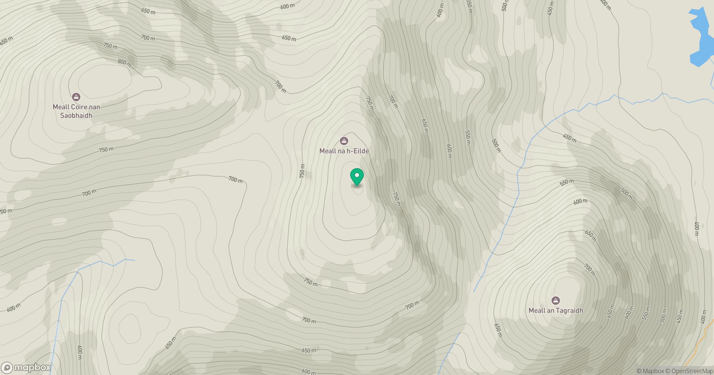
Grid reference: NN185946
View on OpenStreetMapOpens a map in a new tab, centred on the hill.
Nearby Hills
Aonach Mor
1,220m
Carn Mor Dearg
1,221m
Aonach Beag
1,234m

Ben Nevis [Beinn Nibheis]
1,345m
Stob Choire Claurigh
1,177m
No comments yet. Be the first.