
Meall Mor
Good walks are even better shared.
Overview
Meall Mor: The Big Hill of the Highlands
Meall Mor, rising proudly at 928 meters, is a captivating Munro nestled within the scenic Scottish Highlands. Known as 'Big Hill' in Gaelic, this peak rewards hikers with dazzling views and a sense of accomplishment.
Geology
The geological composition of Meall Mor is characterised by granite and schist, providing insight into the Earth's turbulent history in this region. Glacially carved features hint at the tremendous forces that have shaped this landscape, creating the rugged terrain that hikers traverse today.
Routes
Glen Lyon Route
This popular route begins at the shores of Loch an Daimh, winding through tranquil forests that beckon with splashes of colour in the spring. The trail presents a moderate challenge, making it accessible for those keen to scale their first Munro. As you ascend, expect to see the impressive Glen Lyon unfold beneath you, a tapestry of greens and blues.
Summit Features
At the top, a humble cairn marks the summit—an ideal spot for the quintessential Instagram shot. Here, you can look out across the horizon at the neighbouring peaks, including the looming Ben Lawers and the distinctive Tarmachan Ridge.
Terrain Type
Be prepared for a mix of rocky pathways and soft grassy patches, interspersed with the occasional boggy section. Waterproof footwear is advisable, especially in the wetter months when the paths can try to make your hike more interesting!
Views
The vistas from Meall Mor are nothing short of spectacular, particularly on clear days when the expansive glens and formidable peaks reveal their true character. Look out for the shimmering waters of Loch Tay and the majestic mountains rising like giants around you.
Best Seasons for Views
Spring and early autumn are prime times for those dazzling views, with warm weather and less cloud cover than other seasons. Summer brings its own charm with longer daylight hours, ensuring you can fully explore the mountain’s beauty.
Hazards
Hikers should be aware of possible weather changes that can occur within minutes. The final ascent can be steep and tricky, so take care near the edges. Muddy sections can be particularly deceptive post-rain—don't let them foil your plans!
Nearby Summits
For the ambitious, consider extending your adventures to nearby peaks such as Ben Lawers, towering at 1214 meters, or the rounded hills of Meall nan Tarmachan, standing at 1040 meters.
Access
Nearest Parking
Parking is available at the end of a public road near the Loch an Daimh dam. Arrive early to avoid the hassle of searching for a spot.
Public Transport
Public transport options are limited, but there are buses from Aberfeldy to nearby villages, with taxis available to get you closer to the trailhead.
Nearest Town
The charming town of Aberfeldy lies a short distance away, offering a warm cup of tea and a slice of cake after conquering the hill.
Facilities
While the mountain itself lacks facilities, Aberfeldy is well-equipped with cafes, shops, and public toilets to cater to your hiking needs.
History
Meall Mor's name reflects its imposing height, and it holds a place in the cultural narrative of the region, brimming with stories of clan history and battles fought under its watchful gaze.
So whether you're a seasoned Munro-bagger or just looking for a bit of adventure, Meall Mor offers a delightful experience for all! Happy hiking, and don’t forget to take your camera for some snaps.
Explore routes near Meall Mor
Public walks starting within 80 km of this hill. Nearby does not mean a route reaches the summit; check its map and access before setting out.
Glen Affric: Coire Loch Woodland Trail
View route
Inverness: River Ness and Caledonian Canal circuit
View route
Great Glen Way low route: Fort Augustus to Invermoriston Old Bridge
View route
Fort Augustus to Kytra Lock: Caledonian Canal Towpath
View route
Route planning notes
These notes describe possible approaches, not verified navigable routes or permission to cross land. Check current paths, local access rules and conditions before setting out.
Glen Lyon Route
A scenic climb starting from the shores of Loch an Daimh. This route meanders through serene forest paths before ascending towards the peak, offering a gentle introduction to those new to Munros.
Make a day of it, together
Find someone to share the walk with, or organise a day out along a route you like.
Hill facts and local notes
Classifications
Elevation
407m
1,335 ft
Prominence
114m
Coordinates
57.4000, -4.5596
NH463373
OS Map
26
Explorer: 431
At the Summit
The summit features a small stone cairn that provides a perfect photo opportunity for hikers. On a clear day, look for the iconic jagged ridges of neighbouring peaks in the distance.
Terrain & Geology
Meall Mor is primarily composed of granite and schist, typical of the Scottish Highlands. This rocky terrain reveals the geological forces that shaped the landscape over millennia, including glacial activity.
Views & Scenery
From the summit, enjoy views of the expansive Glen Lyon, the longest glen in Scotland, and the striking peaks of the surrounding mountains, including Ben Lawers and the Tarmachan Ridge.
History & Heritage
Name Origin
Meall Mor translates to 'Big Hill' in Scottish Gaelic, a fitting description for its sizable stature.
Historical Significance
The mountain has been a cherished destination for hikers and is part of the historical fabric of the area, known for its rich tales of early Scottish clans.
Getting There & Facilities
Check current local access restrictions, parking rules and transport timetables before travelling. These notes do not confirm public access to the summit.
Parking
Parking is available at the end of the public road near the Loch any Daimh dam. Arrive early, especially on weekends, to secure a space.
Public Transport
The nearest public transport options include buses from Aberfeldy to nearby villages, although a taxi may be required to reach the parking area.
Nearby Facilities
There are no facilities directly on the mountain; however, Aberfeldy has cafes, shops, and public toilets to serve your needs before or after your hike.
Safety Information
Known Hazards
- Be mindful of sudden weather changes, steep drops on the final ascent, and muddy tracks that can be slippery, particularly after rainfall.
General Safety Tips
- Check weather conditions before setting out
- Carry appropriate clothing and equipment
- Let someone know your planned route
- Take a map, compass, and GPS device
- Carry emergency supplies: food, water, first aid kit, torch
Hills
Some common questions about the hills answered
Are there group walks up Meall Mor?
Many walkers use Walkmates to join or organise walks with others. You can check for group walks around Meall Mor through the maps
Are there other walkers around Meall Mor?
Activity varies by location and time, but Walkmates lets you see whether others have shared walks or shown interest in this area. Find other people through the walking friends search walking friends for Meall Mor search or of course create your own walk for Meall Mor
Can I organise a walk to Meall Mor?
Yes. If there aren’t any walks listed already, you can create a walk and make it available for others to join.
If you're signed up to Walkmates, you can create a walk to Meall Mor.
How do I find a walk up this hill?
There are often multiple ways to walk this hill, depending on experience and route preference. Walkmates helps you explore walks and routes that others have shared.
Can I suggest a new route up Meall Mor?
Yes. You can suggest or create routes to share with others. Walkmates focuses on the social side of walking, so routes are used to help people organise walks and explore areas together, rather than as detailed navigation tools or route libraries.
Other uses really appreciate knowledgeable walkers sharing their routes. Share your favourite route to Meall Mor here
The is an error or something incorrect about this hill. How do I let you know?
We always strive to keep the information on Walkmates as accurate as possible. If you find an error, please let us know through the contact form and we'll aim to correct it as quickly as possible
Community Discussion
Comments
Location
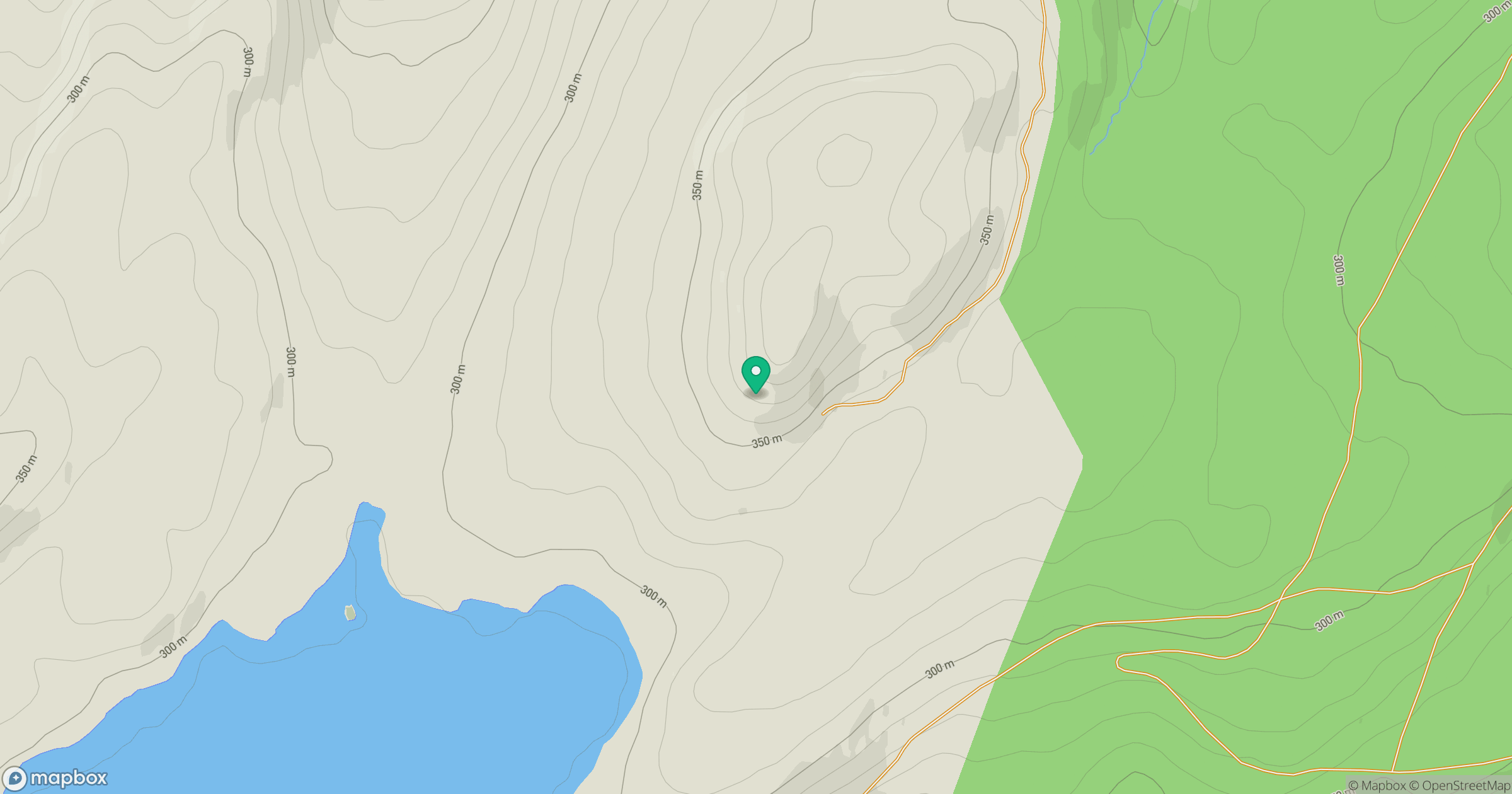
Grid reference: NH463373
View on OpenStreetMapOpens a map in a new tab, centred on the hill.
Hills within 30 km
Straight-line distance, not a walking route or confirmation of access.
Cul Mor
393m
Beinn Mheadhoin
541m
Sgurr a' Choire Ghlais
1,084m
Meall nan Caorach
426m
Bad a' Chlamhain
306m
No comments yet. Be the first.