
Knott
Good walks are even better shared.
Overview
Knott: An Overview
Nestled in the heart of the Lake District, Knott stands proud at 582 meters, offering breathtaking views of its more illustrious neighbours. Despite its understated height, its charm is undeniable.
Geology
Knott is primarily made up of volcanic rock layered with sedimentary stones. This diverse geology not only provides a fascinating insight into the Earth’s past but also offers climbers and walkers a sturdy footing, although a bit of caution is advised around those slippery bits!
Routes
There are a couple of main routes to the summit, ideal for those looking for a decent day's hike.
- Wasdale Head to Knott: This route is straightforward, with stunning scenery along the way, making it a favourite among photographers and nature lovers alike.
- Swindale to Knott: A bit quieter and off the well-trodden path, sniffing out this route rewards you with both tranquillity and the sound of birds singing.
Summit Features
Upon reaching the summit, hikers are greeted by a stone cairn that looks as if it’s seen more than a few sunrises. It’s the perfect spot for a well-deserved snack and, let's face it, an all-important selfie!
Terrain Type
Expect grassy slopes interspersed with rocky outcrops and some boggy sections—so pack those waterproofs, unless you fancy a free mud wrap!
Views
The vistas from Knott are simply spectacular! On a clear day, behold the majesty of Scafell Pike and the tranquil waters of Wastwater, with opportunities for spectacular photographs that will have your friends green with envy.
Hazards
As always in the mountains, be aware of changing weather conditions and remain alert for those slippery rocks. With any luck, you won’t encounter the legendary Lake District ninjas (a.k.a. sheep).
Access
Getting to Knott can be easily done from the Wasdale Head car park, which unfortunately fills up quicker than you can say 'flat white'. Public transport options exist, but be sure to check current timetables to avoid any surprises. The nearest town is Gosforth, where you can stock up on supplies and good cheer before your adventure commences.
Facilities
Don’t expect luxury, but the nearby Wasdale Head has basic offerings. The local pub is a friendly spot, where hikers can share stories of their adventures (or misadventures!).
History
Knott, derived from Old Norse, tells the tale of its ancient past. It’s been a beacon for walkers keen to explore the natural wonders of the Lake District for generations.
So gear up, grab your favourite snack, and head off to Knott for a marvellous day out in the hills. Just remember—a tired hiker is a happy hiker!
Explore routes near Knott
Walks starting near this hill. Open a route to check its map, distance and full itinerary.
Sizergh: Park End Moss and Brigsteer Park Wood Circuit
View route
Striding Edge, Helvellyn and Catstye Cam
View route
Helvellyn via Striding Edge
View route
Long Meg and Lacy's Caves
View route
Route planning notes
These notes describe possible approaches. Check a route's map and access information when planning your walk.
Wasdale Head to Knott
A gentle ascent from Wasdale Head, providing a delightful introduction to the beauty of the Lake District.
Swindale to Knott
A less trodden path that winds through picturesque valleys before climbing to the summit.
Make a day of it, together
Find someone to share the walk with, or organise a day out along a route you like.
Hill facts and local notes
Classifications
Elevation
413m
1,355 ft
Prominence
134m
Coordinates
54.4763, -2.5406
NY650091
OS Map
91
Explorer: OL19N OL19S
At the Summit
The summit features a traditional stone cairn, perfect for that triumphant photo opportunity. A visit to the top isn’t complete without a selfie—after all, how else will you prove you were here?
Terrain & Geology
Primarily composed of volcanic rock and sedimentary layers, Knott offers a side of geological flair that might just rival your morning cuppa. The craggy summit showcases some intriguing formations.
Views & Scenery
From the summit, you can catch views of the mighty Scafell Pike, the shimmering Wastwater, and even the distant peaks of the Coniston range. A real treat for the eyes!
History & Heritage
Name Origin
The name 'Knott' derives from Old Norse, meaning 'hill' or 'knoll'—a fitting name given its charming stature.
Historical Significance
Knott has long been a popular destination for walkers and is noted not just for its scenic beauty, but also as a point on the historic routes through the Lake District.
Getting There & Facilities
Parking
Wasdale Head car park (NY 199 072), with limited spaces available; arrive early to avoid missing out!
Public Transport
Access via local bus services from towns like Seascale or Eskdale; check the latest schedules as they can be as erratic as the weather.
Nearby Facilities
Basic amenities can be found at Wasdale Head including a pub that serves food—but don't expect Michelin stars after a long hike!
Safety Information
Known Hazards
- Variable weather conditions can change quickly, leading to reduced visibility. Watch for slippery rocks and the occasional elusive sheep.
General Safety Tips
- Check weather conditions before setting out
- Carry appropriate clothing and equipment
- Let someone know your planned route
- Take a map, compass, and GPS device
- Carry emergency supplies: food, water, first aid kit, torch
Hills
Some common questions about the hills answered
Are there group walks up Knott?
Many walkers use Walkmates to join or organise walks with others. You can check for group walks around Knott through the maps
Are there other walkers around Knott?
Activity varies by location and time, but Walkmates lets you see whether others have shared walks or shown interest in this area. Find other people through the walking friends search walking friends for Knott search or of course create your own walk for Knott
Can I organise a walk to Knott?
Yes. If there aren’t any walks listed already, you can create a walk and make it available for others to join.
If you're signed up to Walkmates, you can create a walk to Knott.
How do I find a walk up this hill?
There are often multiple ways to walk this hill, depending on experience and route preference. Walkmates helps you explore walks and routes that others have shared.
Can I suggest a new route up Knott?
Yes. You can suggest or create routes to share with others. Walkmates focuses on the social side of walking, so routes are used to help people organise walks and explore areas together, rather than as detailed navigation tools or route libraries.
Other uses really appreciate knowledgeable walkers sharing their routes. Share your favourite route to Knott here
The is an error or something incorrect about this hill. How do I let you know?
We always strive to keep the information on Walkmates as accurate as possible. If you find an error, please let us know through the contact form and we'll aim to correct it as quickly as possible
Community Discussion
Comments
Location
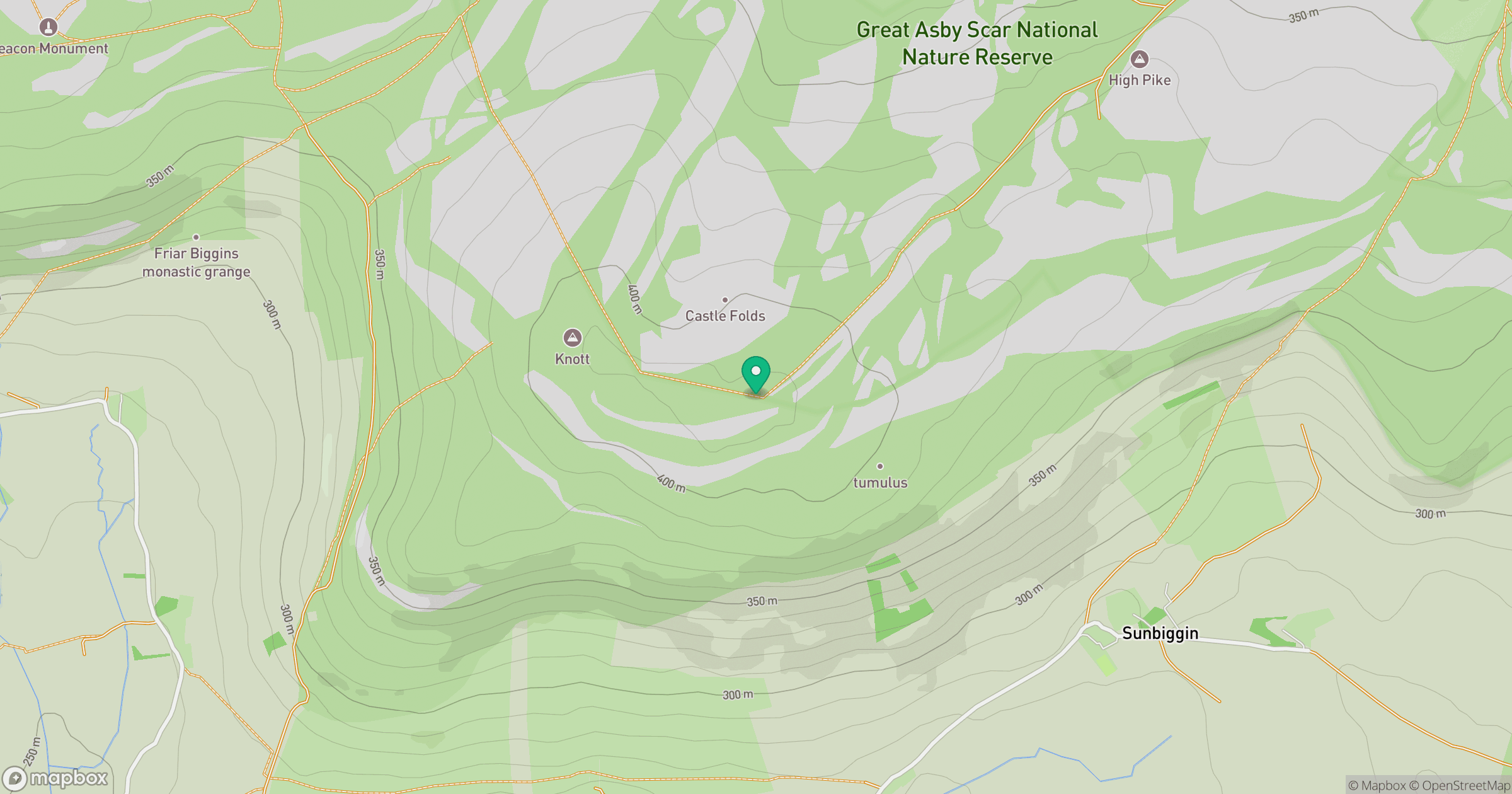
Grid reference: NY650091
View on OpenStreetMapOpens a map in a new tab, centred on the hill.



No comments yet. Be the first.