

Grinshill Hill
Good walks are even better shared.
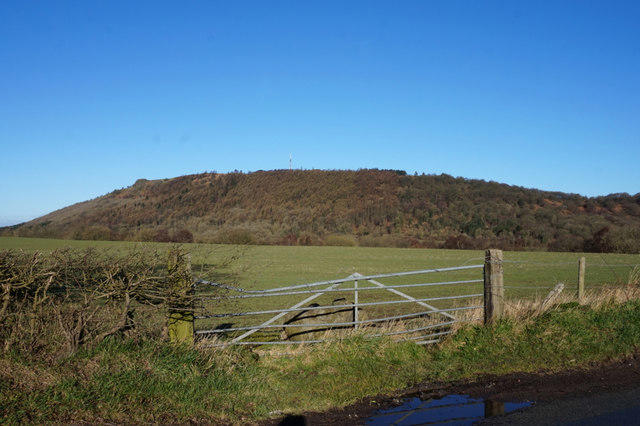
SJ5123 : Springtime view from Grinshill summit area
Jeremy Bolwell Photo source
Overview
Grinshill Hill: A Hidden Gem in Shropshire
Nestled in the heart of the Shropshire Hills, Grinshill Hill stands at an elevation of 223 metres. Though not the highest peak in the region, it offers a charming escape into nature, perfect for a day out.
Geology
The hill is predominantly composed of sandstone, which reveals fascinating geological features as you hike. Look out for exposed rock formations that tell tales of ancient sediments and natural history.
Routes
Grinshill is accessible via a variety of hiking routes:
- Main Circular Route: A 5-km scenic loop that takes about 2 hours to complete. This moderate trail offers a lovely mix of woodlands and fields, making it a delightful outing for families.
- Bramble Path: For those short on time, this 2.5-km hike leads directly to the summit and can be done in about an hour. Easy and quick, it's perfect for the determined!
Summit Features
At the summit, you'll find a distinct trig point, a perfect marker of your achievement. Don't forget to snap a photo, if only to remind friends that you did indeed leave the house!
Terrain
The terrain is a delightful combination of grassy slopes and rocky outcrops. Just watch your step—after a rain shower, things might get squishy.
Views
Once you're at the top, prepare to be rewarded with stunning views of the Shropshire countryside. The Wrekin and even the distant Welsh hills come into view, turning your hike into a memorable visual feast. The best times to appreciate these sights are in spring and autumn when nature showcases its vibrant colours.
Hazards
Be cautious of the mud, especially after a downpour; it can be slippery! Additionally, keep an eye out for loose stones on the steeper sections of the path.
Nearby Summits
If you're up for more adventure, consider checking out:
- The Wrekin (407 m)
- Caer Caradoc (459 m)
Access
For access, the nearest parking is in the quaint village of Grinshill, conveniently situated near the start of your journey. If you prefer public transport, regular buses depart from Shrewsbury, making this hike accessible without the need for a car.
Facilities
While Grinshill Hill itself lacks facilities, don’t fret. The nearby café will rejuvenate you with delightful refreshments after your climb. Tea and cake are simply irresistible!
History
Grinshill's name originates from Old English, meaning 'hill with a green pasture', which nicely reflects the lush surroundings. Historically, it served as a lookout point, offering strategic views across the land.
In conclusion, whether you're an experienced hiker or a Sunday stroller, Grinshill Hill will leave you with stories to tell and views to remember. There’s little better than a walk in the hills, as they say!
Explore routes near Grinshill Hill
Walks starting near this hill. Open a route to check its map, distance and full itinerary.
Haughmond Hill: Henry’s Hike
View route
Shrewsbury Walk with Men Walking & Talking
View route
Colemere and Blakemere Canal Walk
View route
Attingham Park Deer Park and River Tern
View route
Route planning notes
These notes describe possible approaches. Check a route's map and access information when planning your walk.
Main Circular Route
A scenic loop starting from the nearby village of Grinshill, winding through lush woodlands and open fields before ascending the hill.
Bramble Path
A shorter option taking a direct path upwards, perfect for those short on time but still wanting to stretch their legs.
Make a day of it, together
Find someone to share the walk with, or organise a day out along a route you like.
Photo Gallery
View all Photo could not load
SJ5123 : Springtime view from Grinshill summit area
Jeremy Bolwell
 Photo could not load
SJ5123 : View below Grinshill, Shropshire
Jeremy Bolwell
 Photo could not load
SJ5123 : South-east from Grinshill cliff edge
Roy Haworth
 Photo could not load
SJ5123 : At Grinshill cliff edge
Row17
 Photo could not load
SJ5123 : At Grinshill summit on a sunny Spring Sunday
Jeremy Bolwell
 Photo could not load
SJ5123 : The main cliff at Grinshill rocks
Richard Law
 Photo could not load
SJ5123 : Grinshill in winter
Jeremy Bolwell
 Photo could not load
SJ5123 : Approaching the summit area of Grinshill
Jeremy Bolwell
 Photo could not load
SJ5123 : View down to Grinshill village from Grinshill viewpoint
Jeremy Bolwell

SJ5123 : Path near Grinshill (1)
Stephen Richards
Hill facts and local notes
Classifications
Elevation
192m
630 ft
Prominence
102m
Coordinates
52.8090, -2.7146
SJ519237
OS Map
126
Explorer: 241N
At the Summit
The summit is marked by a distinct trig point, offering a perfect spot for a selfie to show off your achievements to friends who chose the sofa over the summit.
Terrain & Geology
Primarily composed of sandstone, Grinshill Hill offers fascinating geological features including exposed rock formations and ancient sediments, showcasing the area's natural history.
Views & Scenery
Outstanding vistas of the surrounding Shropshire countryside, notably the Wrekin and the Welsh hills on a clear day.
History & Heritage
Name Origin
The name Grinshill is derived from Old English, meaning 'hill with a green pasture', a fitting designation for this charming location.
Historical Significance
Historically, the hill has been a lookout point, providing a strategic vantage over the surrounding area.
Getting There & Facilities
Parking
There's a small village car park in Grinshill, conveniently located near the route starting point.
Public Transport
Regular buses run from Shrewsbury to Grinshill, with a short walk to the trailhead.
Nearby Facilities
While the hill itself doesn't offer facilities, nearby Grinshill has a lovely café where you can refuel with tea and cake after your hike.
Safety Information
Known Hazards
- Watch out for mud after rain; it can be slipperier than a greased eel!
- Loose stones and steep drops in some areas require attention.
General Safety Tips
- Check weather conditions before setting out
- Carry appropriate clothing and equipment
- Let someone know your planned route
- Take a map, compass, and GPS device
- Carry emergency supplies: food, water, first aid kit, torch
Hills
Some common questions about the hills answered
Are there group walks up Grinshill Hill?
Many walkers use Walkmates to join or organise walks with others. You can check for group walks around Grinshill Hill through the maps
Are there other walkers around Grinshill Hill?
Activity varies by location and time, but Walkmates lets you see whether others have shared walks or shown interest in this area. Find other people through the walking friends search walking friends for Grinshill Hill search or of course create your own walk for Grinshill Hill
Can I organise a walk to Grinshill Hill?
Yes. If there aren’t any walks listed already, you can create a walk and make it available for others to join.
If you're signed up to Walkmates, you can create a walk to Grinshill Hill.
How do I find a walk up this hill?
There are often multiple ways to walk this hill, depending on experience and route preference. Walkmates helps you explore walks and routes that others have shared.
Can I suggest a new route up Grinshill Hill?
Yes. You can suggest or create routes to share with others. Walkmates focuses on the social side of walking, so routes are used to help people organise walks and explore areas together, rather than as detailed navigation tools or route libraries.
Other uses really appreciate knowledgeable walkers sharing their routes. Share your favourite route to Grinshill Hill here
The is an error or something incorrect about this hill. How do I let you know?
We always strive to keep the information on Walkmates as accurate as possible. If you find an error, please let us know through the contact form and we'll aim to correct it as quickly as possible
Community Discussion
Comments
Location
View the hill's mapped position and surrounding paths.
Grid reference: SJ519237
View on OpenStreetMapOpens a map in a new tab, centred on the hill.
Nearby Hills
The Wrekin
407m
Long Mynd - Pole Bank
517m
Stiperstones
537m
Titterstone Clee Hill
533m
Moel Famau
555m
No comments yet. Be the first.