
Cocklaw Hill
Good walks are even better shared.
Overview
Cocklaw Hill: A Hiker’s Delight
Nestled within the scenic Scottish Borders, Cocklaw Hill stands proud at 476 meters, offering both charm and challenge to hikers of all skill levels. With its classification as a Marilyn, it promises a rewarding experience without the need to tackle the highest peaks.
Geology
The hill is primarily composed of layers of sedimentary rock, including sandstone and shale. This geology adds intrigue to the landscape, creating spectacular rock formations and somewhat unpredictable footing—so keep your eye on the prize, not just your feet!
Routes
The most popular route to Cocklaw Hill is the Newcastleton Circular Route. This trail meanders through the lush landscapes, allowing you to enjoy the beauty of the Scottish countryside. At 8.5 km and taking approximately 3.5 hours, it’s regarded as a moderate challenge, suitable for most outdoor enthusiasts.
Summit Features
Upon reaching the summit, you’re greeted by a rustic stone cairn and a wooden post that marks the high point. It’s a classic scene—a photographer’s dream—so don’t forget your camera, or at least your mobile phone.
Terrain Type
The terrain is predominantly grassy with sporadic rocky outcrops. This combination provides a pleasant hiking experience, but it’s best to wear sturdy footwear—you wouldn’t want to make a mountain out of a molehill!
Views
The views from the top are nothing short of spectacular! On a clear day, the Cheviot Hills stretch out to the south, while the charming village of Newcastleton sits below like a postcard. There’s no better place to soak in the splendour of the Borders, especially in late spring or early autumn when the landscape bursts into colour.
Hazards
As with any mountain, be prepared for sudden changes in weather. Always pack a waterproof jacket (and perhaps a comically oversized one if you wish to entertain fellow hikers). Watch for rocky outcrops, particularly when the ground is wet.
Access
The nearest parking is conveniently located in Newcastleton, with public transport links connecting it to various towns in the area, making it accessible for day trippers and seasoned hikers alike.
Facilities
Newcastleton may be small, but it certainly packs a punch with quaint shops and delightful cafes. Take a break and refuel before or after your expedition.
History
The name 'Cocklaw' signifies its historical roots linked to the cuckoo bird. It’s a reminder of the area's past, where nature and local lore intertwine.
Final Thoughts
Whether you’re a seasoned hiker or a curious newbie, Cocklaw Hill is a must-visit destination. With stunning vistas, a touch of history, and a dash of whimsy, it’s a place that will surely beckon you back.
Happy hiking!
Explore routes near Cocklaw Hill
Public walks starting within 80 km of this hill. Nearby does not mean a route reaches the summit; check its map and access before setting out.
Cockburnspath to Dunglass Dean and Old Bridge
View route
Duns Hen Poo Lake and St Mary’s Glade
View route
Coldingham Creel Path and St Abbs Bay
View route
St Abbs Head Lighthouse and Pettico Wick
View route
Route planning notes
These notes describe possible approaches, not verified navigable routes or permission to cross land. Check current paths, local access rules and conditions before setting out.
Newcastleton Circular Route
A scenic loop starting from Newcastleton, offering lovely views of the surrounding landscape and a gentle ascent to Cocklaw Hill.
Make a day of it, together
Find someone to share the walk with, or organise a day out along a route you like.
Hill facts and local notes
Classifications
Elevation
319m
1,047 ft
Prominence
129m
Coordinates
55.9349, -2.4525
NT718714
OS Map
67
Explorer: 351E
At the Summit
The summit boasts a small stone cairn and a wooden post marking the high point, leaving hikers delighted by a sense of achievement.
Terrain & Geology
Cocklaw Hill is primarily composed of sedimentary rock, featuring layers of sandstone and shale, which have weathered into rocky outcrops, creating interesting formations around the summit area.
Views & Scenery
On a clear day, expect views of the Cheviot Hills to the south and the rolling hills of the Borders region. The picturesque village of Newcastleton is also visible from the summit.
History & Heritage
Name Origin
The name 'Cocklaw' is derived from the Scots word for a 'cuckoo hill' - a nod to the birds that were once abundant in the area.
Historical Significance
Historically, Cocklaw Hill has been a vantage point for local folk, providing views of both the surrounding countryside and potential intruders during times of conflict.
Getting There & Facilities
Check current local access restrictions, parking rules and transport timetables before travelling. These notes do not confirm public access to the summit.
Parking
Parking is available in the village of Newcastleton, conveniently located at the start of most hiking trails.
Public Transport
Regular bus services connect Newcastleton with other towns in the Scottish Borders, but it's advisable to check schedules ahead of time.
Nearby Facilities
Newcastleton has a small selection of shops, cafes, and public toilets for visitors. Perfect for a quick coffee before or after your hike!
Safety Information
Known Hazards
- Be cautious of sudden weather changes; it can go from sunny to ‘Scottish’ in the blink of an eye. Also, be wary of hidden rocky outcrops, especially in wet conditions.
General Safety Tips
- Check weather conditions before setting out
- Carry appropriate clothing and equipment
- Let someone know your planned route
- Take a map, compass, and GPS device
- Carry emergency supplies: food, water, first aid kit, torch
Hills
Some common questions about the hills answered
Are there group walks up Cocklaw Hill?
Many walkers use Walkmates to join or organise walks with others. You can check for group walks around Cocklaw Hill through the maps
Are there other walkers around Cocklaw Hill?
Activity varies by location and time, but Walkmates lets you see whether others have shared walks or shown interest in this area. Find other people through the walking friends search walking friends for Cocklaw Hill search or of course create your own walk for Cocklaw Hill
Can I organise a walk to Cocklaw Hill?
Yes. If there aren’t any walks listed already, you can create a walk and make it available for others to join.
If you're signed up to Walkmates, you can create a walk to Cocklaw Hill.
How do I find a walk up this hill?
There are often multiple ways to walk this hill, depending on experience and route preference. Walkmates helps you explore walks and routes that others have shared.
Can I suggest a new route up Cocklaw Hill?
Yes. You can suggest or create routes to share with others. Walkmates focuses on the social side of walking, so routes are used to help people organise walks and explore areas together, rather than as detailed navigation tools or route libraries.
Other uses really appreciate knowledgeable walkers sharing their routes. Share your favourite route to Cocklaw Hill here
The is an error or something incorrect about this hill. How do I let you know?
We always strive to keep the information on Walkmates as accurate as possible. If you find an error, please let us know through the contact form and we'll aim to correct it as quickly as possible
Community Discussion
Comments
Location
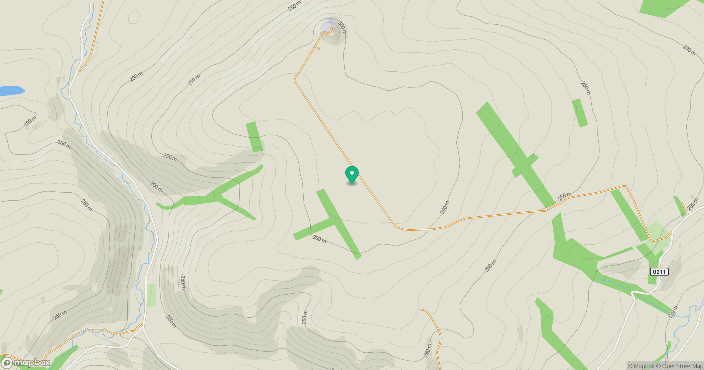
Grid reference: NT718714
View on OpenStreetMapOpens a map in a new tab, centred on the hill.
Hills within 30 km
Straight-line distance, not a walking route or confirmation of access.
No comments yet. Be the first.