
Foel Ddu
Good walks are even better shared.
Overview
Foel Ddu: The Black Hill
Foel Ddu stands proudly at an elevation of 611 meters, part of Snowdonia National Park. It is classified as both a Hewitt and Nuttall, residing in an area renowned for its stunning landscapes and geological diversity.
Geology
With its composition of volcanic slate and shale, Foel Ddu boasts a fascinating geological profile. Its rugged terrain has been shaped by ancient glacial movements, creating a unique environment for hiking and exploration.
Hiking Routes
The Sarn Helen Route offers hikers a delightful mix of ancient history and breathtaking scenery, stretching approximately 8 km. This moderately challenging hike typically takes about 3.5 hours to complete, making it a rewarding excursion for both seasoned walkers and less experienced hikers.
Summit Features
At the summit, you will find a prominent cairn, perfect for resting and taking in the expansive views. Be sure to bring your camera—this is a postcard-worthy spot! On clear days, the stunning peaks of the Glyderau stand proudly on the horizon.
Terrain and Views
The journey to Foel Ddu involves traversing grassy slopes interspersed with rocky outcrops. However, brace yourself—some patches can be boggy! The best time for jaw-dropping vistas is in spring and autumn when the landscape is awash with colours and clarity.
Hazards
While the ascent is a treat, be cautious of slippery paths, particularly after rain. Good hiking boots are a must to navigate through the occasionally boggy terrain.
Nearby Summits
If you're feeling adventurous, consider visiting nearby Carnedd Llewelyn and Foel Grach, which offer additional challenges and views. Combined, these summits can create a rewarding day of hiking!
Access
The nearest parking is a small layby on the A5—arrive early to snag a spot! For those relying on public transport, local buses can take you from Betws-y-Coed to the A5, followed by a short walk. Capel Curig is the closest town, providing ample facilities.
Facilities
While Foel Ddu itself is devoid of facilities, Capel Curig has cafes and toilets available. A perfect pitstop after conquering the hill!
History
The name Foel Ddu, meaning 'Black Hill,' reflects its impressive dark silhouette. Historically, the mountain is significant due to its connection to ancient Roman roadways, making it a culturally rich destination.
So, lace up those boots and embrace the challenge! As they say, it’s not the mountain we conquer, but ourselves—though a bit of stunning scenery doesn't hurt. Happy hiking!
Explore routes near Foel Ddu
Public walks starting within 80 km of this hill. Nearby does not mean a route reaches the summit; check its map and access before setting out.
Cadair Idris - Pony Path
View route
Mawddach Trail: Penmaenpool to Dolgellau Riverside Return
View route
Mawddach Trail: Penmaenpool to Arthog Estuary Return
View route
Mawddach Trail: Dolgellau to Barmouth
View route
Route planning notes
These notes describe possible approaches, not verified navigable routes or permission to cross land. Check current paths, local access rules and conditions before setting out.
Sarn Helen Route
A popular hiking route that follows the ancient Roman road, offering a mix of historic intrigue and stunning landscape views.
Make a day of it, together
Find someone to share the walk with, or organise a day out along a route you like.
Hill facts and local notes
Classifications
Elevation
448m
1,470 ft
Prominence
129m
Coordinates
52.6680, -3.9278
SH697095
OS Map
124
Explorer: OL23W
At the Summit
The summit is marked by a distinctive cairn, which serves as a great spot for a cheeky selfie. On a clear day, you might even get a glimpse of Snowdon in the distance.
Terrain & Geology
Foel Ddu is primarily composed of volcanic slate and shale, which gives it a rugged character. The area's geological history includes significant glacial activity, evident in the surrounding features.
Views & Scenery
From the summit, hikers can enjoy sweeping views of the surrounding mountains and valleys, including the majestic peaks of the Glyderau.
History & Heritage
Name Origin
Foel Ddu translates to 'Black Hill' in English, likely referring to its dark, rugged appearance.
Historical Significance
The area holds rich historical significance with ancient pathways and remnants of Roman roads, revealing its long-standing cultural heritage.
Getting There & Facilities
Check current local access restrictions, parking rules and transport timetables before travelling. These notes do not confirm public access to the summit.
Parking
The nearest parking is at the small layby off the A5 road, roughly 2 km from the trailhead. Make sure to get there early during weekends as it can fill up quickly.
Public Transport
Buses run from nearby towns like Betws-y-Coed to the A5, with a short walk to the trailhead required.
Nearby Facilities
There are no facilities at the summit, but you can find cafes and toilets in Capel Curig, perfect for a post-hike snack or refreshment.
Safety Information
Known Hazards
- Beware of slippery paths, especially in wet conditions. Some areas can be boggy, so sturdy footwear is advised.
General Safety Tips
- Check weather conditions before setting out
- Carry appropriate clothing and equipment
- Let someone know your planned route
- Take a map, compass, and GPS device
- Carry emergency supplies: food, water, first aid kit, torch
Hills
Some common questions about the hills answered
Are there group walks up Foel Ddu?
Many walkers use Walkmates to join or organise walks with others. You can check for group walks around Foel Ddu through the maps
Are there other walkers around Foel Ddu?
Activity varies by location and time, but Walkmates lets you see whether others have shared walks or shown interest in this area. Find other people through the walking friends search walking friends for Foel Ddu search or of course create your own walk for Foel Ddu
Can I organise a walk to Foel Ddu?
Yes. If there aren’t any walks listed already, you can create a walk and make it available for others to join.
If you're signed up to Walkmates, you can create a walk to Foel Ddu.
How do I find a walk up this hill?
There are often multiple ways to walk this hill, depending on experience and route preference. Walkmates helps you explore walks and routes that others have shared.
Can I suggest a new route up Foel Ddu?
Yes. You can suggest or create routes to share with others. Walkmates focuses on the social side of walking, so routes are used to help people organise walks and explore areas together, rather than as detailed navigation tools or route libraries.
Other uses really appreciate knowledgeable walkers sharing their routes. Share your favourite route to Foel Ddu here
The is an error or something incorrect about this hill. How do I let you know?
We always strive to keep the information on Walkmates as accurate as possible. If you find an error, please let us know through the contact form and we'll aim to correct it as quickly as possible
Community Discussion
Comments
Location
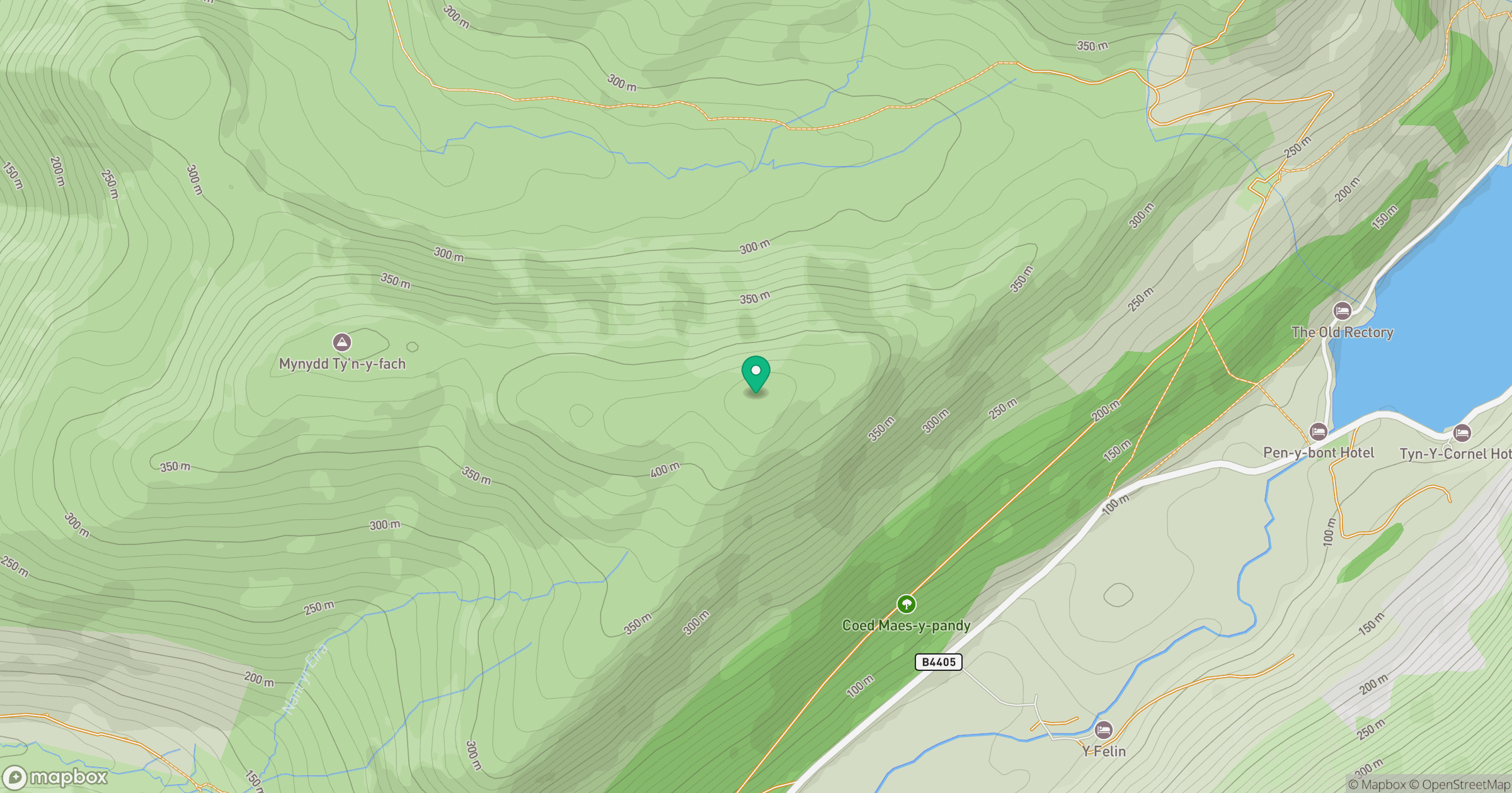
Grid reference: SH697095
View on OpenStreetMapOpens a map in a new tab, centred on the hill.
Hills within 30 km
Straight-line distance, not a walking route or confirmation of access.
Cadair Idris - Penygadair
893m
Y Garn
629m
Rhinog Fawr
721m
Pumlumon Fawr [Plynlimon]
753m
Aran Fawddwy
906m
No comments yet. Be the first.