

Carn Easgann Bana
Good walks are even better shared.
Overview
Carn Easgann Bana: A Hiker’s Gem in the Scottish Highlands
Nestled in the Scottish Highlands, Carn Easgann Bana stands at an impressive 894 meters, earning its place among the Munros. This stunning peak offers a delightful challenge for hikers, promising breathtaking views and a touch of Highland charm.
Geology
The mountain's rugged features are primarily crafted from granite and schist. The geological history is as vivid as the landscape itself, having been shaped over 400 million years through glaciation. You'll encounter spectacular rock formations along your ascent, which may inspire thoughts of ancient giants sculpting their playgrounds.
Popular Routes
Hikers can choose from a couple of main routes:
- East Ridge Route: An easier and more scenic option, this 7.5 km trek takes around 3.5 hours. It’s perfect for those wanting a more leisurely experience while soaking in the views.
- North-West Face Route: Reserved for those with a sense of adventure, this challenging route stretches 5 km and can take 4 hours. Expect some scrambles and an adrenaline rush!
Summit Features
Upon reaching the summit, you’ll find a prominent stone cairn – a well-deserved reward after your climb! The trig point nearby gives a scenic backdrop for that 'I conquered a Munro' selfie.
Terrain Type
Prepare for a mix of rocky paths and grassy patches with occasional bogs. As always, sturdy footwear is a must unless you fancy a foot bath!
The Views
On clear days, the panorama from the top is absolutely magnificent. Spot Loch Ness sparkling in the distance and the sprawling peaks of the Highlands surrounding you. Spring and Autumn are the best seasons for these views, ensuring you get the best out of your hiking endeavours.
Hazards
As with any mountain, be mindful of changing weather conditions; they can shift faster than you can say 'raincoat'. Keep an eye on loose rocks during your ascent; they tend to have a mind of their own!
Nearby Summits
If you’re keen for more, consider bagging a few neighbouring peaks like Carn Mhath (903 m) or Beinn Dronaig (811 m). The more, the merrier, right?
Access Information
The nearest parking area can be found at NH470060, about 3 km from the hiking routes. For those preferring public transport, there’s a bus that runs from Inverness to Fort Augustus, a charming little village where you’ll also find cafes and amenities.
Facilities
Before heading up, grab a bite to eat in Fort Augustus and take advantage of the public toilets – they come in handy!
History
Carn Easgann Bana translates to 'the hill of the white descent', a nod to the splendid snowy views it offers during winter. This mountain is not just a pretty face; it carries tales from Highland folklore, connecting hikers with layers of culture and history as they climb.
In summary, whether you're summiting solo or with friends, Carn Easgann Bana is an unforgettable experience. Pack your gear, lace your boots, and let the adventure begin!
Happy hiking!
Explore routes near Carn Easgann Bana
Public walks starting within 80 km of this hill. Nearby does not mean a route reaches the summit; check its map and access before setting out.
Great Glen Way low route: Fort Augustus to Invermoriston Old Bridge
View route
Fort Augustus to Kytra Lock: Caledonian Canal Towpath
View route
Coire Ardair lochan from Aberarder and back
View route
Glen Affric: Coire Loch Woodland Trail
View route
Route planning notes
These notes describe possible approaches, not verified navigable routes or permission to cross land. Check current paths, local access rules and conditions before setting out.
East Ridge Route
This traditional ascent involves a gentle climb along an eastward ridge, providing stunning views as you approach the summit.
North-West Face Route
A more challenging route that takes you directly up the rocky face of the mountain, best suited for seasoned hikers.
Make a day of it, together
Find someone to share the walk with, or organise a day out along a route you like.
Photo Gallery
View all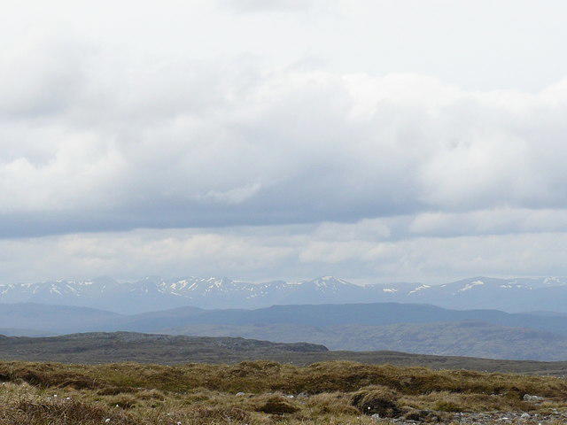 Photo could not load
NH4806 : Looking West from NE shoulder of Carn Easgann Bàna
Sarah McGuire
Hill facts and local notes
Classifications
Elevation
781m
2,562 ft
Prominence
142m
Coordinates
57.1226, -4.5040
NH485063
OS Map
34
Explorer: OL55 401
At the Summit
The summit is marked by a substantial stone cairn, which is a popular photo spot for hikers. On a clear day, you'll also find a trig point nearby.
Terrain & Geology
Carn Easgann Bana is primarily composed of granite and schist, which contribute to its rugged terrain and spectacular rock formations. The geological history of the region dates back over 400 million years, shaped by the forces of glaciation and erosion.
Views & Scenery
From the summit, enjoy views of Loch Ness to the south and the vast expanse of the Highlands, including the peaks of the surrounding Munros.
History & Heritage
Name Origin
The name 'Carn Easgann Bana' translates to 'the hill of the white descent', reflecting the snowy peaks often present during winter months.
Historical Significance
This region is rich in ancient history, with evidence of past settlements and stories from local folklore surrounding the spirit of the mountain.
Getting There & Facilities
Check current local access restrictions, parking rules and transport timetables before travelling. These notes do not confirm public access to the summit.
Parking
There’s a small parking area at NH470060, approximately 3 km from the start of the hiking routes.
Public Transport
The nearest bus service operates from Inverness to Fort Augustus, with a stop near the parking area. Be sure to check the latest timetables.
Nearby Facilities
Cafés and public toilets are available in Fort Augustus. It's wise to use facilities before heading up the hill!
Safety Information
Known Hazards
- Watch out for sudden weather changes; conditions can turn quickly in the Highlands. Loose rocks on the ascent can pose a risk, so exercise caution.
General Safety Tips
- Check weather conditions before setting out
- Carry appropriate clothing and equipment
- Let someone know your planned route
- Take a map, compass, and GPS device
- Carry emergency supplies: food, water, first aid kit, torch
Hills
Some common questions about the hills answered
Are there group walks up Carn Easgann Bana?
Many walkers use Walkmates to join or organise walks with others. You can check for group walks around Carn Easgann Bana through the maps
Are there other walkers around Carn Easgann Bana?
Activity varies by location and time, but Walkmates lets you see whether others have shared walks or shown interest in this area. Find other people through the walking friends search walking friends for Carn Easgann Bana search or of course create your own walk for Carn Easgann Bana
Can I organise a walk to Carn Easgann Bana?
Yes. If there aren’t any walks listed already, you can create a walk and make it available for others to join.
If you're signed up to Walkmates, you can create a walk to Carn Easgann Bana.
How do I find a walk up this hill?
There are often multiple ways to walk this hill, depending on experience and route preference. Walkmates helps you explore walks and routes that others have shared.
Can I suggest a new route up Carn Easgann Bana?
Yes. You can suggest or create routes to share with others. Walkmates focuses on the social side of walking, so routes are used to help people organise walks and explore areas together, rather than as detailed navigation tools or route libraries.
Other uses really appreciate knowledgeable walkers sharing their routes. Share your favourite route to Carn Easgann Bana here
The is an error or something incorrect about this hill. How do I let you know?
We always strive to keep the information on Walkmates as accurate as possible. If you find an error, please let us know through the contact form and we'll aim to correct it as quickly as possible
Community Discussion
Comments
Location
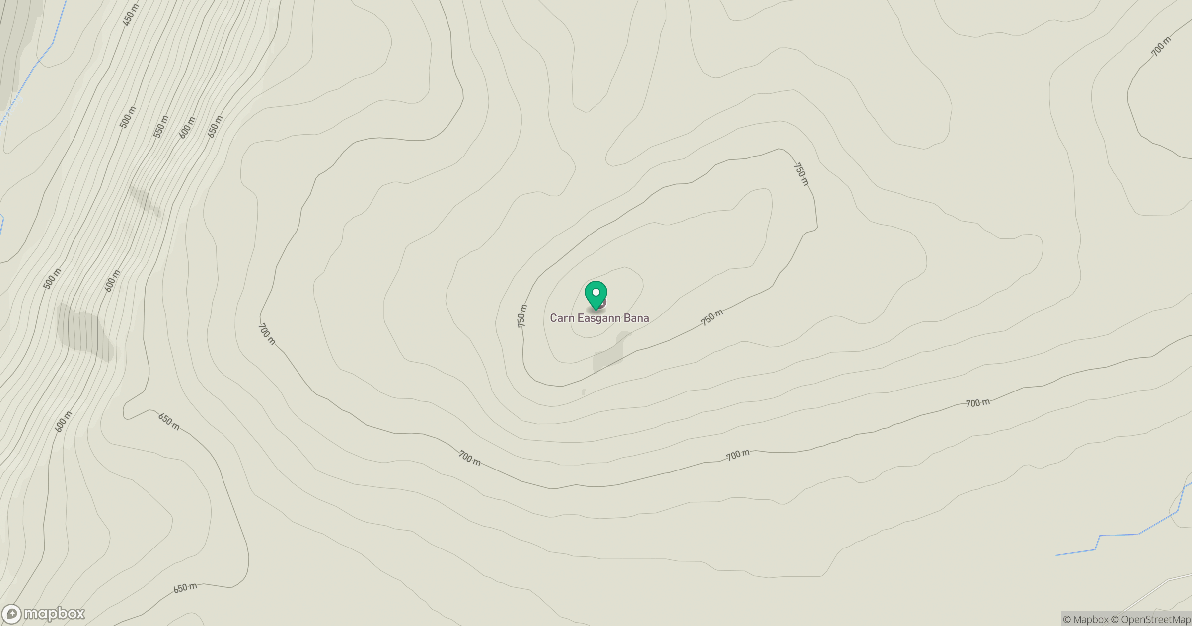
Grid reference: NH485063
View on OpenStreetMapOpens a map in a new tab, centred on the hill.
Hills within 30 km
Straight-line distance, not a walking route or confirmation of access.
Beinn Mheadhoin
541m
Creag Meagaidh
1,128m
Binnein Mor
550m
Meall an Tarsaid
492m
Meall na h-Aisre
862m
No comments yet. Be the first.