

Scratchbury Hill
Good walks are even better shared.
ST9144 : Scratchbury Hill
Roger Gittins Photo source
Overview
Overview
Scratchbury Hill stands proudly at 191 meters, challenging the grandeur of its higher cousins nearby. It may not be the tallest peak in the region, but what it lacks in height, it makes up for in charm and history.
Geology
The hill's composition of chalk and flint provides a glimpse into the geological history of the area. These materials are characteristic of the Chilterns and downs of southern England, promising interesting formations and a varied ecosystem.
Routes
The Scratchbury Hill Circular Walk is a pleasant route perfect for families and casual walkers. As you venture around the hill, you'll be treated to a medley of terrains from woodland paths to expansive grassy slopes. Remember to grab your picnic, as there are plenty of spots to enjoy lunch with a view!
Summit Features
At the top, there's a charming wooden marker; unfortunately, no bronze statues or pizza parlours have taken residence just yet! But the serenity and expansive views make up for that.
Terrain Type
Expect a grassy ascent with gentle slopes, punctuated by lovely woodland areas. Ideal for a stroll, bringing along a four-legged friend is highly recommended (but don't expect them to carry your lunch).
Views
The summit provides splendid vistas, particularly to the Wylye Valley and beyond. It’s a canvas painted with pastoral beauty, particularly enchanting during the spring blooms or autumn's fiery foliage.
Hazards
Don’t let the tranquil setting fool you; weather can change quicker than you can say 'cuppa'. Dress accordingly and keep an eye on the skies!
Nearby Summits
For those craving more elevation after Scratchbury, Cley Hill is just a hop, skip, and jump away, offering a bit more elevation if you’re feeling energetic.
Access
Parking is available at Stourton Village Hall, and it's just a quaint walk over to the trailhead. Public transport is a viable option too, with regular bus services from Warminster.
Facilities
While the hill itself is refreshingly natural, Warminster is nearby, providing ample cafes for a cup of tea and a slice of cake after your walk.
History
The etymology of Scratchbury suggests a connection to grazing pasture, perhaps hinting that sheep were once the hill’s primary visitors. The landscape bears historical evidence of human endeavour, with ancient earthworks from the Iron Age whispering tales of yesteryears.
Whether you’re after a peaceful stroll or a historical jaunt, Scratchbury Hill has something for everyone. So lace up your boots, pack your curiosity and enjoy discovering this hidden gem!
Explore routes near Scratchbury Hill
Walks starting near this hill. Open a route to check its map, distance and full itinerary.
Warminster Walk with Men Walking & Talking
View route
Heal Somerset wetland ranger walk
View route
Heal Somerset wetland ranger walk
View route
Mindful photowalk at Heal Somerset
View route
Route planning notes
These notes describe possible approaches. Check a route's map and access information when planning your walk.
Scratchbury Hill Circular Walk
A delightful circular route starting from the village of Stourton, offering a mix of woodland and open fields with stunning views over the countryside.
Make a day of it, together
Find someone to share the walk with, or organise a day out along a route you like.
Photo Gallery
View all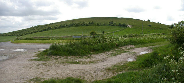 Photo could not load
ST9144 : Scratchbury Hill
Roger Gittins
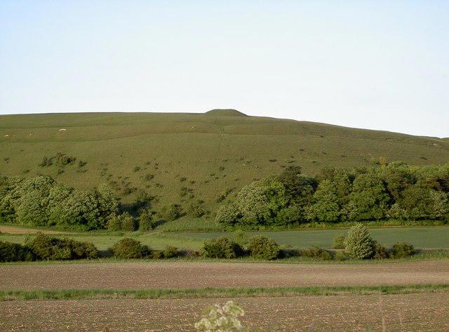 Photo could not load
ST9144 : Scratchbury Hill
Neil Owen
Hill facts and local notes
Classifications
Elevation
197m
646 ft
Prominence
60m
Coordinates
51.1975, -2.1277
ST911442
OS Map
184
Explorer: 143
At the Summit
At the summit, you'll find a simple wooden marker indicating the high point, along with expansive views of the surrounding landscapes.
Terrain & Geology
Scratchbury Hill is predominantly composed of chalk and flint, which makes for a fascinating study in erosion and natural history. The hill is part of the ancient chalk landscape that characterizes much of southern England.
Views & Scenery
From the summit, enjoy picturesque views of the surrounding countryside, including the nearby village of Stourton and the stunning landscapes of the Wylye Valley.
History & Heritage
Name Origin
The name 'Scratchbury' is thought to derive from Old English, possibly referring to the hill being a place where livestock grazed or scratched.
Historical Significance
Scratchbury Hill has historical significance with ancient earthworks dating back to the Iron Age, showcasing the area's long-standing human activity.
Getting There & Facilities
Parking
The nearest parking is available at the Stourton Village Hall, just a short walk from the trailhead.
Public Transport
Buses from Warminster to Stourton run regularly, making it accessible for those using public transport.
Nearby Facilities
There are no facilities directly on the hill, but nearby Warminster has various cafes and public toilets.
Safety Information
Known Hazards
- While the routes are generally safe, beware of sudden changes in weather, as conditions can shift quickly in the hills.
General Safety Tips
- Check weather conditions before setting out
- Carry appropriate clothing and equipment
- Let someone know your planned route
- Take a map, compass, and GPS device
- Carry emergency supplies: food, water, first aid kit, torch
Hills
Some common questions about the hills answered
Are there group walks up Scratchbury Hill?
Many walkers use Walkmates to join or organise walks with others. You can check for group walks around Scratchbury Hill through the maps
Are there other walkers around Scratchbury Hill?
Activity varies by location and time, but Walkmates lets you see whether others have shared walks or shown interest in this area. Find other people through the walking friends search walking friends for Scratchbury Hill search or of course create your own walk for Scratchbury Hill
Can I organise a walk to Scratchbury Hill?
Yes. If there aren’t any walks listed already, you can create a walk and make it available for others to join.
If you're signed up to Walkmates, you can create a walk to Scratchbury Hill.
How do I find a walk up this hill?
There are often multiple ways to walk this hill, depending on experience and route preference. Walkmates helps you explore walks and routes that others have shared.
Can I suggest a new route up Scratchbury Hill?
Yes. You can suggest or create routes to share with others. Walkmates focuses on the social side of walking, so routes are used to help people organise walks and explore areas together, rather than as detailed navigation tools or route libraries.
Other uses really appreciate knowledgeable walkers sharing their routes. Share your favourite route to Scratchbury Hill here
The is an error or something incorrect about this hill. How do I let you know?
We always strive to keep the information on Walkmates as accurate as possible. If you find an error, please let us know through the contact form and we'll aim to correct it as quickly as possible
Community Discussion
Comments
Location
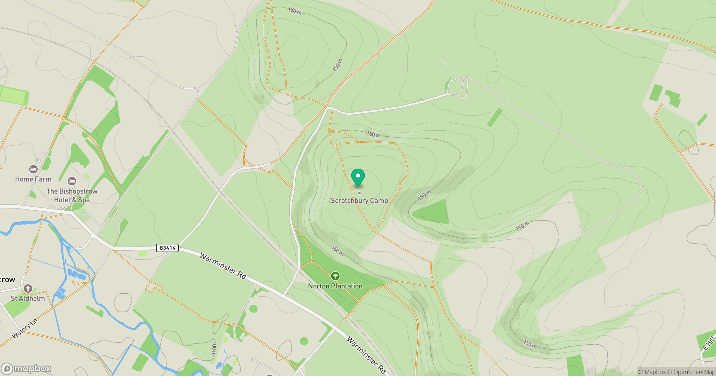
Grid reference: ST911442
View on OpenStreetMapOpens a map in a new tab, centred on the hill.
Nearby Hills
Glastonbury Tor
158m
Worcestershire Beacon
425m
Titterstone Clee Hill
533m

Dunkery Beacon
520m

Cribyn
794m
No comments yet. Be the first.