

Little Doward
Good walks are even better shared.
SO5316 : Wooded slopes of Little Doward
Pauline E Photo source
Overview
Little Doward: A Hiker's Delight
Little Doward, a prominent Marilyn situated in the picturesque Wye Valley, stands proudly at an elevation of 250 meters. Despite its modest stature, it offers magnificent views that would make even the most seasoned mountaineer sit up and take notice.
Geology
The mountain's limestone composition contributes to its rugged beauty. It's not just rocks, folks; it's geological history you can walk upon! The area is rich in biological diversity, supporting various species both on the hills and in the adjacent woodlands.
Routes
For those wondering how to tackle this hill, the Wye Circular Trail is a popular way to start. This route is approximately 6.5 km long and is expected to take about two hours. The ascent weaves through beautiful woodlands, leading you along the banks of the Wye River. Ideal for birdwatchers and families alike, it's a moderately challenging ferry to the summit.
Summit Features
Once you reach the top, you'll find a sturdy trig point that beckons for a selfie. The panoramic vistas from this high point are worth the legwork! Trust me; you’ll want to Instagram this moment.
Terrain Type
Expect a mixture of grassy fields dotted with rocky outcrops, making this trek a pleasurable blend of nature's finest – just be wary of those muddy patches if the weather has been less than kind.
Views
Highlights
The summit rewards hikers with breathtaking views, showcasing the winding River Wye and expansive lowland scenery. On a clear day, the Welsh hills loom beautifully in the distance, giving you all the feels of a postcard pic.
Best Seasons
Spring and autumn are best for optimal views. The spring flowers are simply stunning, and autumn tags along with a canvas of warm colours and crisp air.
Hazards
Keep your wits about you near the summit; some areas have steep drop-offs, and it can be muddy after rain. Good footwear is essential, so unless you'd fancy a mud bath, lace up proper hiking boots!
Nearby Summits
If you're feeling particularly energetic, consider combining your Little Doward expedition with a jaunt to Great Doward or Yat Rock, both providing their own unique vistas.
Access
Nearest Parking: Whitchurch boasts a convenient car park located just 1 km from the start of the trail.
Public Transport: Regular bus services connect Monmouth to Whitchurch, making it easy to access without a car.
Nearest Town: Charming Monmouth is the closest town, offering delightful cafes and local shops.
Facilities
The village of Whitchurch has a couple of local cafes where you can get a hot drink and potentially some biscuits – because what’s a hike without a biscuit?
History
Name Meaning
The name 'Doward' harks back to ancient times, derived from Old English, and can be interpreted as 'hill'. Quite fitting, wouldn't you say?
Significance
Little Doward is more than just a hill; it’s interwoven with history and ancient settlements, giving it a cultural richness that hikers can feel while exploring the area.
In conclusion, Little Doward may not have the towering height of its neighbouring mountains, but its charm, spectacular views, and varied hiking trails make it a beloved spot for adventurers. So lace up those boots, grab a map, and head on up!
Explore routes near Little Doward
Walks starting near this hill. Open a route to check its map, distance and full itinerary.
Forest of Dean Hicksters Way Woodland Circuit from Cannop
View route
Forest of Dean Full Colliers Trail from Cannop Ponds
View route
Clytha Estate: River Usk, Chapel Ruins and Castle Woods
View route
Goytre Wharf to Pentre Bridge: Mon and Brec Canal Walk
View route
Route planning notes
These notes describe possible approaches. Check a route's map and access information when planning your walk.
The Wye Circular Trail
A scenic route starting at the nearby village of Whitchurch, taking you through woodlands and along the river before ascending Little Doward.
Make a day of it, together
Find someone to share the walk with, or organise a day out along a route you like.
Photo Gallery
View all Photo could not load
SO5316 : Wooded slopes of Little Doward
Pauline E
 Photo could not load
SO5316 : Little Doward
Rude Health
 Photo could not load
SO5316 : Rampart on Little Doward viewed from the Triangulation Pillar
Peter Wood
Hill facts and local notes
Classifications
Elevation
222m
730 ft
Prominence
128m
Coordinates
51.8418, -2.6706
SO538161
OS Map
162
Explorer: OL14W
At the Summit
A prominent trig point stands at the summit, providing a perfect excuse to take a rest and snap a selfie with a view.
Terrain & Geology
Little Doward is primarily composed of limestone, which has shaped the dramatic cliffs and rolling hills of the area. The limestone outcrops are home to a variety of flora and fauna, adding to the area's ecological importance.
Views & Scenery
From the summit, hikers can enjoy spectacular views of the River Wye, the surrounding lowlands, and the Welsh hills in the distance.
History & Heritage
Name Origin
The name 'Doward' is believed to be derived from Old English, meaning 'hill' or 'mountain', signifying the region's topography.
Historical Significance
The area around Little Doward has historical significance, having been inhabited since prehistoric times, with evidence of ancient settlements nearby.
Getting There & Facilities
Parking
There is a car park located in Whitchurch, approximately 1 km from the trailhead to Little Doward.
Public Transport
Bus services run from Monmouth to Whitchurch, providing an accessible route for those using public transport.
Nearby Facilities
There are local cafes in Whitchurch where hikers can grab a bite to eat and use public toilets before commencing their adventure.
Safety Information
Known Hazards
- Be mindful of steep drop-offs around the summit area. Additionally, some paths can be muddy after rainfall, so sturdy footwear is recommended.
General Safety Tips
- Check weather conditions before setting out
- Carry appropriate clothing and equipment
- Let someone know your planned route
- Take a map, compass, and GPS device
- Carry emergency supplies: food, water, first aid kit, torch
Hills
Some common questions about the hills answered
Are there group walks up Little Doward?
Many walkers use Walkmates to join or organise walks with others. You can check for group walks around Little Doward through the maps
Are there other walkers around Little Doward?
Activity varies by location and time, but Walkmates lets you see whether others have shared walks or shown interest in this area. Find other people through the walking friends search walking friends for Little Doward search or of course create your own walk for Little Doward
Can I organise a walk to Little Doward?
Yes. If there aren’t any walks listed already, you can create a walk and make it available for others to join.
If you're signed up to Walkmates, you can create a walk to Little Doward.
How do I find a walk up this hill?
There are often multiple ways to walk this hill, depending on experience and route preference. Walkmates helps you explore walks and routes that others have shared.
Can I suggest a new route up Little Doward?
Yes. You can suggest or create routes to share with others. Walkmates focuses on the social side of walking, so routes are used to help people organise walks and explore areas together, rather than as detailed navigation tools or route libraries.
Other uses really appreciate knowledgeable walkers sharing their routes. Share your favourite route to Little Doward here
The is an error or something incorrect about this hill. How do I let you know?
We always strive to keep the information on Walkmates as accurate as possible. If you find an error, please let us know through the contact form and we'll aim to correct it as quickly as possible
Community Discussion
Comments
Location
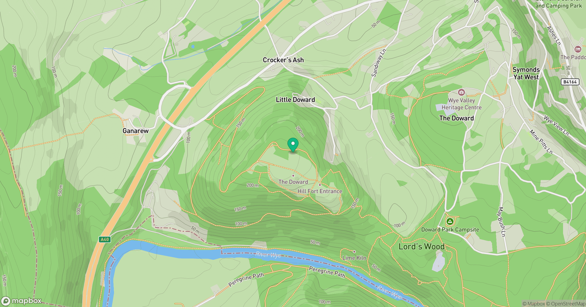
Grid reference: SO538161
View on OpenStreetMapOpens a map in a new tab, centred on the hill.
Nearby Hills
Worcestershire Beacon
425m
Titterstone Clee Hill
533m
Glastonbury Tor
158m
Long Mynd - Pole Bank
517m
Cribyn
794m
No comments yet. Be the first.