
Kit Hill
Good walks are even better shared.
Overview
Kit Hill is a 334.1 m Marilyn above Callington in Cornwall, with a summit chimney and country-park paths through historic mine workings and granite quarries.
Kit Hill (Cornwall)
Kit Hill is a 334.1 m Marilyn above Callington. The highest ground is at the base of the summit chimney, at SX 37487 71343. The trig point 60 m to the east is 2 m lower.
Walking
The circular walk described here starts and finishes at the summit car park. It visits the summit chimney and South Kit Hill Mine, crosses the access road at the middle car park, passes the quarry entrance and climbs back to the top car park. The AA gives 4 km and 1.5 hours for this whole circuit. Rocky ground, gates and steps feature along the way.
Access and safety
Kit Hill is access land, but mine workings and quarry faces make it important to stay on paths. Ground can be uneven and wet. Horse riders should use the blue-arrow permissive horse trail; riding is not permitted on the footpaths or summit. Keep dogs on leads from 1 March to 31 July and whenever livestock are present. Fires and overnight camping are not permitted.
Landscape and history
Granite formed here as molten rock cooled below the earth's surface. Mineral-bearing fractures were worked for tin, copper and tungsten. The summit chimney dates from 1858 and served Kit Hill Great Consols mine. The surviving summit enclosure is a folly built for Sir John Call around 1780.
Views extend across the Tamar Valley towards Dartmoor and Bodmin Moor. Hingston Down, at 268 m, is a neighbouring summit to the east.
Getting there and facilities
The vehicle approach is from the east, off the road between Monkscross on the B3257 and Silver Valley on the A390. The summit car park is at SX 37476 71380. Gunnislake station, about 3 miles east of the hill, is on the Tamar Valley Line from Plymouth.
There are viewing tables and resting places near the summit. The country park has no public toilets. Louis Tea Rooms is by the park entrance; public toilets are on New Road in Callington.
Explore routes near Kit Hill
Walks starting near this hill. Open a route to check its map, distance and full itinerary.
Cotehele: Danescombe Valley and Mining Heritage Circuit
View route
Lanhydrock: Deer Wall, River Fowey and Woodland Circuit
View route
Holsworthy Woods Level 3 walk
View route
Holsworthy Woods Level 2 walk
View route
Route planning notes
These notes describe possible approaches. Check a route's map and access information when planning your walk.
Kit Hill Circular Walk
Start and finish at the summit car park. Visit the summit chimney, descend to South Kit Hill Mine, then continue via the middle car park and cross the access road. Pass the quarry entrance and follow the rocky paths uphill to return to the top car park. This is the AA's complete 4 km circuit, with a guide time of 1.5 hours. Includes gates, steps and uneven rocky ground; stay on paths around mine workings.
Make a day of it, together
Find someone to share the walk with, or organise a day out along a route you like.
Hill facts and local notes
Classifications
Elevation
334m
1,096 ft
Prominence
171m
Coordinates
50.5192, -4.2939
SX374713
OS Map
201
Explorer: 108
At the Summit
The highest ground is at the base of the summit chimney (SX 37487 71343). The trig point 60 m east at SX 37544 71361 is 2 m lower.
Terrain & Geology
Kit Hill is a granite outcrop. Its granite formed as molten rock cooled and solidified deep underground. Mineral-rich fluids entered fractures and formed lodes containing tin, copper and tungsten ores.
Views & Scenery
Views across the Tamar Valley towards Dartmoor and Bodmin Moor.
History & Heritage
Historical Significance
The 1858 summit chimney served Kit Hill Great Consols mine. The summit enclosure is a folly built for Sir John Call around 1780. Prehistoric barrows, mine workings and granite quarries preserve several periods of activity on the hill.
Getting There & Facilities
Parking
The summit car park is at SX 37476 71380. Drive in from the east, off the road linking Monkscross on the B3257 with Silver Valley on the A390. There is also parking at the foot of the old incline on the north side, just off the B3257.
Public Transport
Gunnislake station, approximately 3 miles east of Kit Hill, is on the Tamar Valley Line from Plymouth.
Nearby Facilities
Viewing tables and resting places are provided near the summit. The country park has no public toilets. Louis Tea Rooms is by the park entrance; public toilets are on New Road in Callington.
Safety Information
Known Hazards
- Mine shafts, old workings and quarry faces: stay on the paths and outside fenced areas.
- Uneven rocky paths and locally wet ground; the circular route includes steps and an access-road crossing.
- Livestock graze the hill. Keep dogs on leads near livestock and close gates.
- Horse riders must use the blue-arrow permissive horse trail; no riding on footpaths or the summit.
Seasonal Hazards
Keep dogs on leads during the bird-nesting season, 1 March to 31 July. Adders can bask on sunny slopes in summer.
General Safety Tips
- Check weather conditions before setting out
- Carry appropriate clothing and equipment
- Let someone know your planned route
- Take a map, compass, and GPS device
- Carry emergency supplies: food, water, first aid kit, torch
Hills
Some common questions about the hills answered
Are there group walks up Kit Hill?
Many walkers use Walkmates to join or organise walks with others. You can check for group walks around Kit Hill through the maps
Are there other walkers around Kit Hill?
Activity varies by location and time, but Walkmates lets you see whether others have shared walks or shown interest in this area. Find other people through the walking friends search walking friends for Kit Hill search or of course create your own walk for Kit Hill
Can I organise a walk to Kit Hill?
Yes. If there aren’t any walks listed already, you can create a walk and make it available for others to join.
If you're signed up to Walkmates, you can create a walk to Kit Hill.
How do I find a walk up this hill?
There are often multiple ways to walk this hill, depending on experience and route preference. Walkmates helps you explore walks and routes that others have shared.
Can I suggest a new route up Kit Hill?
Yes. You can suggest or create routes to share with others. Walkmates focuses on the social side of walking, so routes are used to help people organise walks and explore areas together, rather than as detailed navigation tools or route libraries.
Other uses really appreciate knowledgeable walkers sharing their routes. Share your favourite route to Kit Hill here
The is an error or something incorrect about this hill. How do I let you know?
We always strive to keep the information on Walkmates as accurate as possible. If you find an error, please let us know through the contact form and we'll aim to correct it as quickly as possible
Community Discussion
Comments
Location
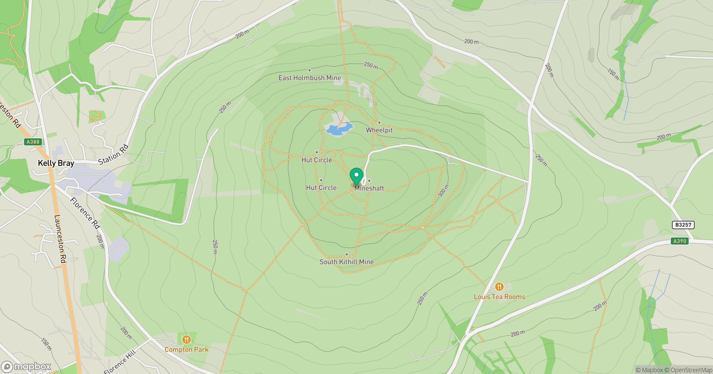
Grid reference: SX374713
View on OpenStreetMapOpens a map in a new tab, centred on the hill.
Nearby Hills

Brent Tor
334m
Brown Willy
420m

High Willhays
622m

Dunkery Beacon
520m
Rhossili Down - The Beacon
193m
No comments yet. Be the first.