

Highdown Hill
Good walks are even better shared.
Overview
Highdown Hill
Highdown Hill is not just any hill; it's a delightful Marilyn that offers both casual hikers and seasoned walkers a treat for the eye and the soul. Standing proud at an elevation of 90 meters, it's an inviting summit that packs a punch in beauty without the daunting climb.
Geology
Formed from the ever-whimsical chalk, Highdown Hill is part of the South Downs. This soft rock supports a rich tapestry of wildlife and wildflowers, making it a key area for both botanists and bee enthusiasts.
Routes
The most popular route is the Highdown Hill Circular Walk. Starting from the charming Highdown Gardens, this 3.2 km trek offers easy walking, lovely views, and enough charm to make a perfect afternoon adventure. It typically takes about 1.5 hours, giving you ample time to soak in the surroundings while negotiating the odd sheep!
Summit Features
At the summit, the trig point not only marks your achievement but also affords you stunning vistas that make every step worth it. Feel free to strike a pose at the top; you’ve earned it!
Terrain Type
The terrain is predominantly grassy, allowing for a pleasant walk that rarely strays into the realm of strenuous. It’s a hill that welcomes you with open arms—just watch for the sheep!
Views
From the top, you can enjoy spectacular views over Worthing and beyond, stretching out to the coastline. The best seasons to experience these views are spring and autumn, when nature shows off its finest colours and the skies cooperate nicely.
Hazards
While the climb is easy-going, beware of the wind—Highdown can be a bit breezy at the top! And don’t forget those local sheep; they seem to consider the paths their own!
Nearby Summits
If you're feeling adventurous, nearby you'll find Cissbury Ring and Chanctonbury Ring—further opportunities to stretch your legs and explore the South Downs.
Access
The Nearest Parking is at Highdown Gardens Car Park, just off the A27. If public transport is more your style, both Worthing and Goring-by-Sea stations are within reach, followed by a quick bus ride. Nearby Worthing is your closest town, so you’ll never be far from civilisation—and fish and chips!
Facilities
The area boasts facilities like toilets and a café at Highdown Gardens, perfect for a pre- or post-hike bite.
History
The name 'Highdown' hints at its lofty position and historical significance. With chalk pits dating back to the Neolithic, this hill has stories to tell!
So, pack your gear and lace up those boots; an enjoyable outing awaits on Highdown Hill!
Explore routes near Highdown Hill
Public walks starting within 80 km of this hill. Nearby does not mean a route reaches the summit; check its map and access before setting out.
Shoreham-by-Sea Walk with Men Walking & Talking
View route
Bognor Regis Walk with Men Walking & Talking
View route
Bognor Regis Walk & Talk
View route
Bognor Regis Walk & Talk
View route
Route planning notes
These notes describe possible approaches, not verified navigable routes or permission to cross land. Check current paths, local access rules and conditions before setting out.
Highdown Hill Circular Walk
A scenic circular route that starts from Highdown Gardens, leading hikers through stunning views and diverse wildlife.
Make a day of it, together
Find someone to share the walk with, or organise a day out along a route you like.
Photo Gallery
View all Photo could not load
TQ0904 : The Miller's Tomb
Peter Jeffery
 Photo could not load
TQ0904 : Track to Hangleton Lane
Peter Holmes
 Photo could not load
TQ0904 : View from Highdown Hill
Simon Carey
 Photo could not load
TQ0904 : Highdown Hill
Simon Carey
 Photo could not load
TQ0904 : Highdown Hill
Simon Carey
 Photo could not load
TQ0904 : Approaching the summit of Highdown Hill
Peter Jeffery
 Photo could not load
TQ0904 : Iron Age Fort, Highdown Hill
Simon Carey
 Photo could not load
TQ0904 : Trees on the old fort
Des Blenkinsopp
 Photo could not load
TQ0904 : Highdown Hill
Simon Carey

TQ0904 : Highdown Hill
Simon Carey
Hill facts and local notes
Classifications
Elevation
81m
266 ft
Prominence
41m
Coordinates
50.8279, -0.4509
TQ092043
OS Map
198
Explorer: OL10 121
At the Summit
At the summit, you will find a prominent trig point which serves as a useful marker for navigation, along with breathtaking panoramic views.
Terrain & Geology
Highdown Hill is formed from chalk, a soft and porous sedimentary rock, which contributes to its unique flora and fauna. The hill is part of the South Downs, a range known for its rolling hills and open landscapes.
Views & Scenery
From the summit, you'll see the stunning coastline at Worthing, as well as the sprawling fields of the South Downs National Park.
History & Heritage
Name Origin
The name 'Highdown' likely refers to its elevated position on the downs, as 'down' is an Old English term for hill.
Historical Significance
Highdown Hill holds historical significance with ancient chalk pits dating back to the Neolithic era.
Getting There & Facilities
Check current local access restrictions, parking rules and transport timetables before travelling. These notes do not confirm public access to the summit.
Parking
Highdown Gardens Car Park, just off the A27, offers ample parking with easy access to the hill.
Public Transport
You can take a train to either Worthing or Goring-by-Sea stations, followed by a short bus ride to reach the hill.
Nearby Facilities
Nearby, in Highdown Gardens, there are toilets and a café where you can grab a cuppa before your ascent.
Safety Information
Known Hazards
- Be aware of strong winds at the summit and the occasional sheep on the path; they don't yield easily to hikers!
General Safety Tips
- Check weather conditions before setting out
- Carry appropriate clothing and equipment
- Let someone know your planned route
- Take a map, compass, and GPS device
- Carry emergency supplies: food, water, first aid kit, torch
Hills
Some common questions about the hills answered
Are there group walks up Highdown Hill?
Many walkers use Walkmates to join or organise walks with others. You can check for group walks around Highdown Hill through the maps
Are there other walkers around Highdown Hill?
Activity varies by location and time, but Walkmates lets you see whether others have shared walks or shown interest in this area. Find other people through the walking friends search walking friends for Highdown Hill search or of course create your own walk for Highdown Hill
Can I organise a walk to Highdown Hill?
Yes. If there aren’t any walks listed already, you can create a walk and make it available for others to join.
If you're signed up to Walkmates, you can create a walk to Highdown Hill.
How do I find a walk up this hill?
There are often multiple ways to walk this hill, depending on experience and route preference. Walkmates helps you explore walks and routes that others have shared.
Can I suggest a new route up Highdown Hill?
Yes. You can suggest or create routes to share with others. Walkmates focuses on the social side of walking, so routes are used to help people organise walks and explore areas together, rather than as detailed navigation tools or route libraries.
Other uses really appreciate knowledgeable walkers sharing their routes. Share your favourite route to Highdown Hill here
The is an error or something incorrect about this hill. How do I let you know?
We always strive to keep the information on Walkmates as accurate as possible. If you find an error, please let us know through the contact form and we'll aim to correct it as quickly as possible
Community Discussion
Comments
Location
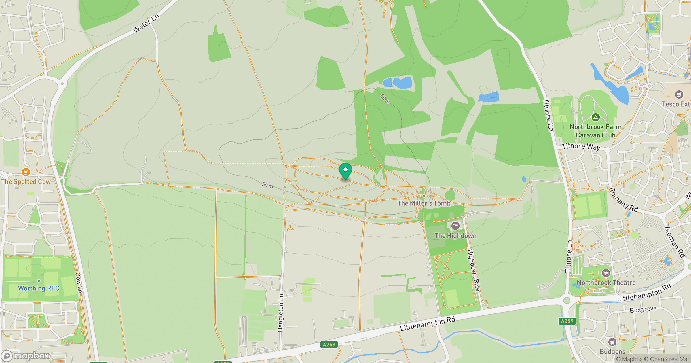
Grid reference: TQ092043
View on OpenStreetMapOpens a map in a new tab, centred on the hill.
Hills within 30 km
Straight-line distance, not a walking route or confirmation of access.
No comments yet. Be the first.