
Gamallt
Good walks are even better shared.
Overview
Gamallt: Summit of Character
Nestled within the enchanting Snowdonia National Park, Gamallt stands at a modest 487 meters, but don’t let its stature fool you. This Marilyn offers hiking enthusiasts a delightful escape into a landscape brimming with natural beauty and steeped in history.
Geology
Gamallt is primarily made up of sedimentary rocks, primarily sandstone and shale. This geological makeup tells a tale of ancient seabeds that once teemed with life, now transformed into the striking hills of Snowdonia. You’ll notice how the rocks seem to narrate stories of eras gone by during your ascent.
Routes
The most popular route to the summit is the Gamallt Circular Walk, which starts at the picturesque village of Ffestiniog. This moderate trek spans approximately 8 km and can be comfortably completed in around 3.5 hours, not counting the time you’ll want to spend taking in those unbeatable views (or recovering from the last hill!).
Summit Features
Upon reaching the top, hikers are greeted by a robust stone cairn, an iconic feature marking the peak. It’s a perfect spot for photos, especially when you can back it up with dramatic landscapes in the background. On a clear day, you might even catch a glimpse of the Irish Sea—don’t forget to aim for the sea, not just the clouds!
Terrain
The terrain is mostly grassy with the occasional rocky outcrop or boggy patch—ideal for those who enjoy a bit of varied footing. Good boots are your friends here, as are sturdy walking sticks, particularly on the slippery bits.
Views
The views from Gamallt are nothing short of spectacular. Gaze northward toward the mighty Snowdon, and south toward the rugged hills of the Rhinogs. My recommendation? Pack a picnic and enjoy the scenery; just watch out for those pesky seagulls who seem to know when you have food!
Best Seasons
Spring and autumn are fabulous times to hike Gamallt, with spring bringing a bloom of wildflowers and autumn showcasing vibrant foliage. Winter also offers a crisp and challenging alternative, perfect for the more adventurous souls among us.
Hazards
Although not overly perilous, wild weather can sweep in at a moment's notice, so check the forecast before setting out. Remember, you’d rather be safe than soaked!
Nearby Summits
If you're looking to extend your day in the hills, consider visiting nearby summits such as Tegid (678 meters) and Moelwyn Mawr (770 meters), both of which boast their own unique charms and challenges.
Access
Gamallt is easily accessible from Ffestiniog, where you can park your car or catch a bus from Blaenau Ffestiniog. Start your journey refreshed and ready to conquer the hills!
Facilities
Before you set off or after you return from your trek, Ffestiniog offers a variety of cafes to indulge in a well-earned slice of cake or a warming drink—perfect for reminiscing about your adventure.
History
The name Gamallt means 'the place of the crooked one' in Welsh, a nod to its unique topography. Historically, this mountain holds significance for local folklore and was once crucial for local communities as a lookout point.
In conclusion, Gamallt may not be the tallest mountain in Snowdonia, but what it lacks in height it makes up for in charm, beauty, and a hearty adventure waiting for you to explore. So, tie your laces tight, and let the adventure unfold!
Explore routes near Gamallt
Public walks starting within 80 km of this hill. Nearby does not mean a route reaches the summit; check its map and access before setting out.
Elan Valley: Reservoir Trail to Pen y Garreg Dam
View route
Hafren Forest: full Source of the Severn Trail
View route
Ystwyth Trail: Black Covert to Llanilar and back
View route
Dolaucothi Estate: Cothi Valley and Red Waymarked Circuit
View route
Route planning notes
These notes describe possible approaches, not verified navigable routes or permission to cross land. Check current paths, local access rules and conditions before setting out.
Gamallt Circular Walk
A delightful circular route starting and ending at the village of Ffestiniog, offering panoramic views and a gentle ascent to the summit.
Make a day of it, together
Find someone to share the walk with, or organise a day out along a route you like.
Hill facts and local notes
Classifications
Elevation
475m
1,557 ft
Prominence
147m
Coordinates
52.3266, -3.5342
SN955709
OS Map
136 147
Explorer: 200W
At the Summit
The summit is adorned with a prominent stone cairn, providing a perfect photo opportunity. The views are a reward in themselves and on a clear day, you might even see the Irish Sea!
Terrain & Geology
Gamallt is primarily composed of sedimentary rock, with layers of sandstone and shale providing a rich geological tapestry. The formations are remnants of ancient seabeds, showcasing the area's dynamic geological history.
Views & Scenery
From the summit, gaze upon the breathtaking peaks of Snowdon to the north and the rugged hills of the Rhinogs to the south.
History & Heritage
Name Origin
Gamallt derives from the Welsh meaning 'the place of the crooked one', likely referring to its rugged and twisted terrain.
Historical Significance
Historically, this mountain was significant to the local communities, serving as a lookout and part of routes that are embedded in local folklore.
Getting There & Facilities
Check current local access restrictions, parking rules and transport timetables before travelling. These notes do not confirm public access to the summit.
Parking
There is parking available at the village of Ffestiniog, approximately 1 km from the trailhead.
Public Transport
Buses from Blaenau Ffestiniog run regularly, providing access to the village and the starting point of the Gamallt route.
Nearby Facilities
Ffestiniog village offers several small shops and cafés to refuel before or after your hike, and public toilets are available at the village centre.
Safety Information
Known Hazards
- Keep an eye out for sudden changes in weather, as the mountain’s character can shift from sunny to stormy quicker than you can say 'packed lunch'.
General Safety Tips
- Check weather conditions before setting out
- Carry appropriate clothing and equipment
- Let someone know your planned route
- Take a map, compass, and GPS device
- Carry emergency supplies: food, water, first aid kit, torch
Hills
Some common questions about the hills answered
Are there group walks up Gamallt?
Many walkers use Walkmates to join or organise walks with others. You can check for group walks around Gamallt through the maps
Are there other walkers around Gamallt?
Activity varies by location and time, but Walkmates lets you see whether others have shared walks or shown interest in this area. Find other people through the walking friends search walking friends for Gamallt search or of course create your own walk for Gamallt
Can I organise a walk to Gamallt?
Yes. If there aren’t any walks listed already, you can create a walk and make it available for others to join.
If you're signed up to Walkmates, you can create a walk to Gamallt.
How do I find a walk up this hill?
There are often multiple ways to walk this hill, depending on experience and route preference. Walkmates helps you explore walks and routes that others have shared.
Can I suggest a new route up Gamallt?
Yes. You can suggest or create routes to share with others. Walkmates focuses on the social side of walking, so routes are used to help people organise walks and explore areas together, rather than as detailed navigation tools or route libraries.
Other uses really appreciate knowledgeable walkers sharing their routes. Share your favourite route to Gamallt here
The is an error or something incorrect about this hill. How do I let you know?
We always strive to keep the information on Walkmates as accurate as possible. If you find an error, please let us know through the contact form and we'll aim to correct it as quickly as possible
Community Discussion
Comments
Location
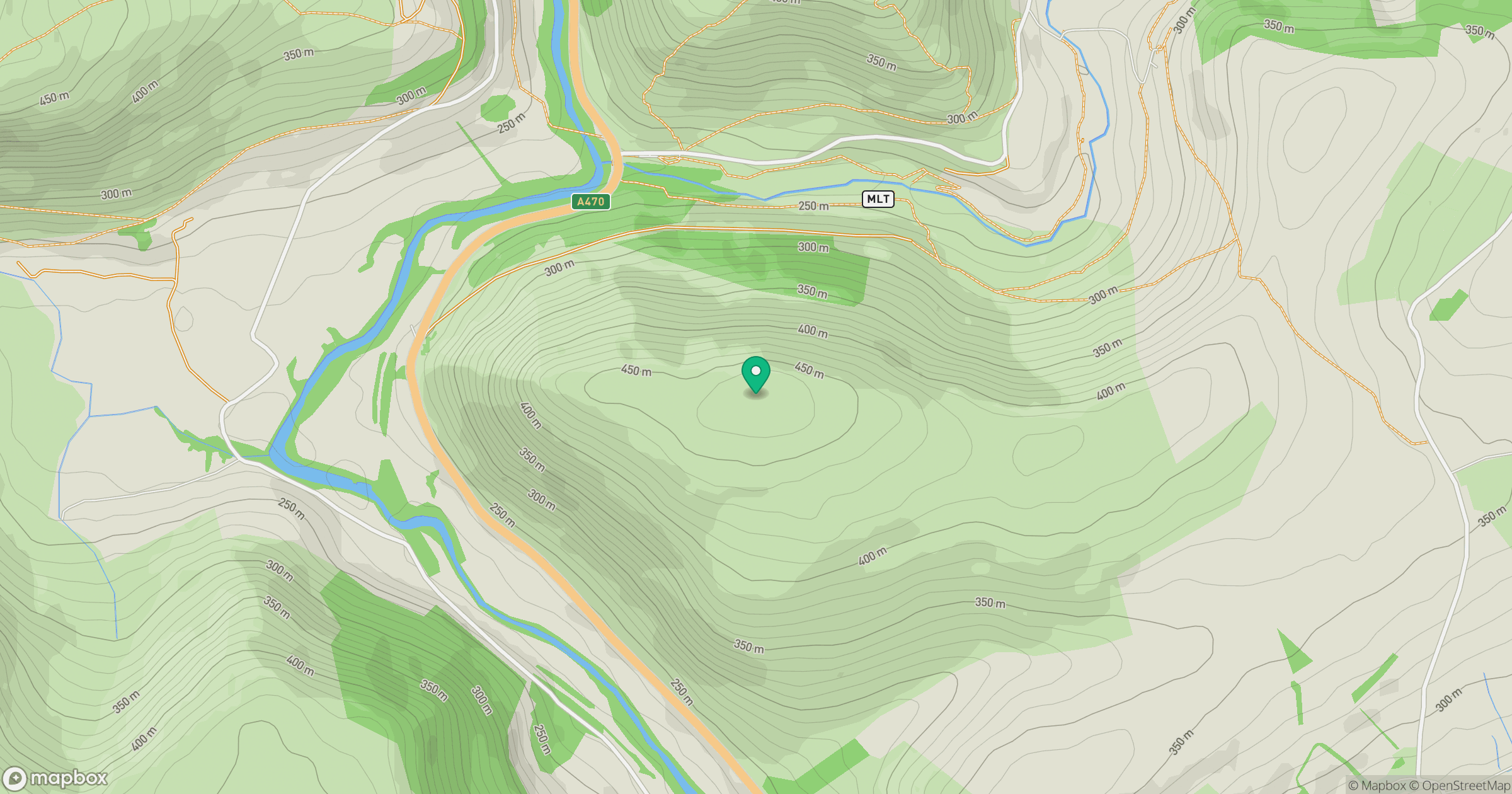
Grid reference: SN955709
View on OpenStreetMapOpens a map in a new tab, centred on the hill.
Hills within 30 km
Straight-line distance, not a walking route or confirmation of access.
Carneddau
445m
Pumlumon Fawr [Plynlimon]
753m
Garreg Lwyd
498m
Esgair Penygarreg
533m
Cefn Cenarth
460m
No comments yet. Be the first.