
Dunnichen Hill
Good walks are even better shared.
Overview
Dunnichen Hill
Overview
Dunnichen Hill, perched at 247 meters, may not be the highest in Scotland, but it's certainly one of the most charming Marilyns you'll encounter. Nestled in the Central Lowlands, it’s an ideal spot for a relaxed hike or a family day out in nature.
Geology
The geological formations here tell a fascinating story of Scotland's past, with a mix of sedimentary rocks and occasional volcanic intrusions. It's like nature's own history book, albeit a rather large one that you have to walk to read!
Routes
Starting from the minor road north of the hill, the Dunnichen Hill Circuit encompasses 4.5 km of easy walking that anyone from toddlers to grandparents can enjoy. The trail offers a blend of grassy areas and well-worn paths, making it perfect for a leisurely outing. Plan for around 1.5 hours to soak in the views and catch a breather.
Summit Features
Upon reaching the summit, you'll be greeted by a trig point, marking the height of your achievement – perfect for bragging rights and photos. There's also a small stone cairn that adds a bit of character to the peak.
Terrain Type
Expect a friendly mix of grassy slopes and rocky outcrops. The terrain is forgiving, making for an accessible hiking experience that won’t leave you breathless…unless you’re running for the summit to claim your tug-of-war championship!
Views
On a clear day, the panoramic views are nothing short of spectacular. You can gaze over the River Tay, with miles of stunning landscapes extending across the Central Lowlands. The best time to enjoy these vistas is during the late spring or early autumn, when nature really shows off its finery.
Hazards
While Dunnichen Hill is relatively safe, keep an eye out for wildlife, particularly ticks in the warmer months. Also, be cautious of slippery paths during wet weather; you wouldn’t want to make a dramatic slide into a bog.
Nearby Summits
For those looking to hit up more peaks, the nearby Baldovan Hill (267m) and Rumbling Bridge Cave (186m) are also worth a visit. Make a day of it – more summits, more fun!
Access
Nearest Parking
You’ll find parking along the minor road at NO509494, suitable for a handful of cars.
Public Transport
The closest bus stop is in the village of Murroes, located around 2 km from the hill. Dundee provides regular bus services to this quaint location.
Nearest Town
Dundee, about 7 miles away, offers all the conveniences you might need before or after your adventure.
Facilities
There are no facilities directly on the hill. However, Murroes has a small shop for snacks. If you’re after a full meal, head into Dundee for some of the local fare.
History
The name 'Dunnichen' likely stems from Scottish Gaelic, meaning 'hill of the fort', which hints at its historical importance. Not just an aesthetic wonder, this little hill holds stories of local significance.
So lace up your boots, grab your walking stick, and head on out to Dunnichen Hill for a stellar day in nature, with memories waiting to be made!
Conclusion
Dunnichen Hill is waiting for you, so what are you waiting for? A slice of nature, a sprinkle of history, and breathtaking views await.
Explore routes near Dunnichen Hill
Public walks starting within 80 km of this hill. Nearby does not mean a route reaches the summit; check its map and access before setting out.
Forfar to Lunanhead: East Road and the Ditches Walk
View route
Club outing: Auchnafree Hill (shared-car departure)
View route
Club outing: Lomond Hills (shared-car departure)
View route
Club outing: Carn a’ Gheoidh (shared-car departure)
View route
Route planning notes
These notes describe possible approaches, not verified navigable routes or permission to cross land. Check current paths, local access rules and conditions before setting out.
Dunnichen Hill Circuit
A pleasant loop starting from a minor road north of the hill, providing a mix of paths and open grassy areas.
Make a day of it, together
Find someone to share the walk with, or organise a day out along a route you like.
Hill facts and local notes
Classifications
Elevation
233m
764 ft
Prominence
129m
Coordinates
56.6364, -2.8006
NO509496
OS Map
54
Explorer: 382S 389
At the Summit
The summit features a weathered trig point, which is notorious for providing a great photo opportunity, as well as a small stone cairn marking the top.
Terrain & Geology
Dunnichen Hill is comprised primarily of sedimentary rock interspersed with volcanic intrusions. The hill reveals interesting geological formations that can educate the curious hiker about Scotland's dynamic geological history.
Views & Scenery
From the summit, hikers can enjoy expansive views over the surrounding countryside, including the nearby River Tay and the sprawling landscapes of the Central Lowlands.
History & Heritage
Name Origin
The name 'Dunnichen' originates from Scottish Gaelic, possibly meaning 'hill of the fort'.
Historical Significance
Historically, Dunnichen Hill may have been a site of local significance due to its height offering a strategic lookout point.
Getting There & Facilities
Check current local access restrictions, parking rules and transport timetables before travelling. These notes do not confirm public access to the summit.
Parking
The nearest parking is available along the minor road at NO509494. It can accommodate a few vehicles; just be mindful not to block access.
Public Transport
The nearest bus stop is located in the village of Murroes, approximately 2 km away. Buses operate regularly from Dundee.
Nearby Facilities
There are no facilities directly on the hill, but the nearby village of Murroes offers a small shop for supplies and local cafes in Dundee provide refreshments.
Safety Information
Known Hazards
- Watch out for wildlife, particularly ticks in warmer months. In wet weather, the paths can become slippery.
General Safety Tips
- Check weather conditions before setting out
- Carry appropriate clothing and equipment
- Let someone know your planned route
- Take a map, compass, and GPS device
- Carry emergency supplies: food, water, first aid kit, torch
Hills
Some common questions about the hills answered
Are there group walks up Dunnichen Hill?
Many walkers use Walkmates to join or organise walks with others. You can check for group walks around Dunnichen Hill through the maps
Are there other walkers around Dunnichen Hill?
Activity varies by location and time, but Walkmates lets you see whether others have shared walks or shown interest in this area. Find other people through the walking friends search walking friends for Dunnichen Hill search or of course create your own walk for Dunnichen Hill
Can I organise a walk to Dunnichen Hill?
Yes. If there aren’t any walks listed already, you can create a walk and make it available for others to join.
If you're signed up to Walkmates, you can create a walk to Dunnichen Hill.
How do I find a walk up this hill?
There are often multiple ways to walk this hill, depending on experience and route preference. Walkmates helps you explore walks and routes that others have shared.
Can I suggest a new route up Dunnichen Hill?
Yes. You can suggest or create routes to share with others. Walkmates focuses on the social side of walking, so routes are used to help people organise walks and explore areas together, rather than as detailed navigation tools or route libraries.
Other uses really appreciate knowledgeable walkers sharing their routes. Share your favourite route to Dunnichen Hill here
The is an error or something incorrect about this hill. How do I let you know?
We always strive to keep the information on Walkmates as accurate as possible. If you find an error, please let us know through the contact form and we'll aim to correct it as quickly as possible
Community Discussion
Comments
Location
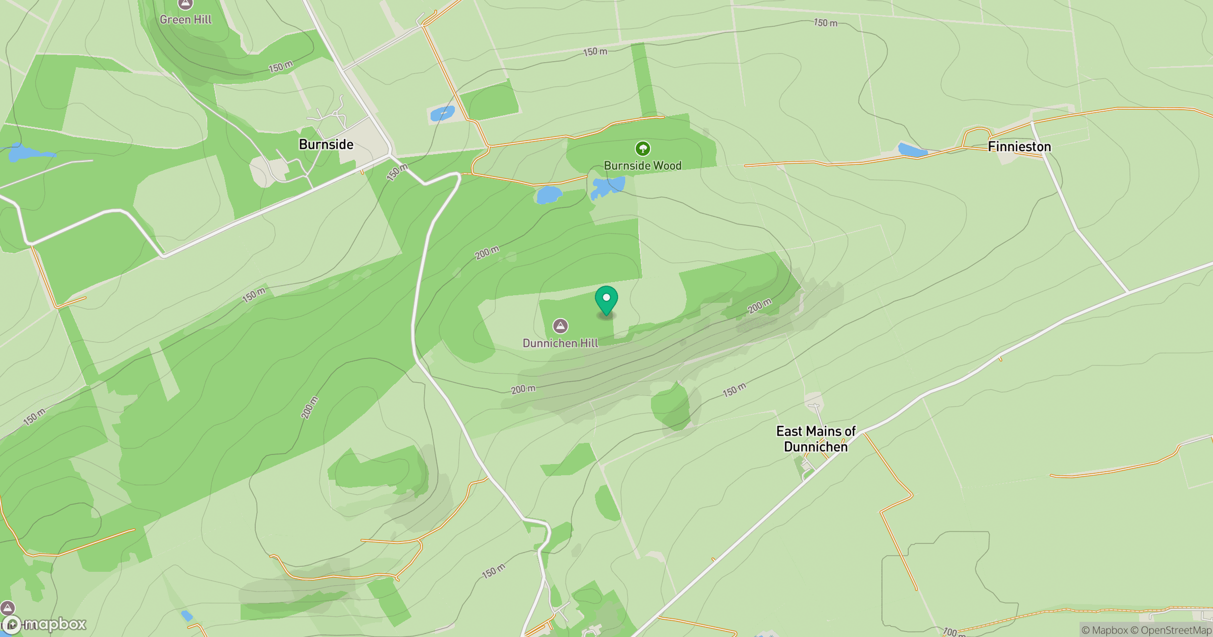
Grid reference: NO509496
View on OpenStreetMapOpens a map in a new tab, centred on the hill.
Hills within 30 km
Straight-line distance, not a walking route or confirmation of access.
No comments yet. Be the first.