
Muireann Mhor
Good walks are even better shared.
Overview
Muireann Mhor
Nestled in the stunning Scottish Highlands, Muireann Mhor is a delight for hikers craving both challenge and beauty. At 745 meters, it's classified as a Marilyn, offering a unique blend of scenic trails and striking vistas.
Geology
As you ascend, you'll notice the rocky terrain composed of schist and granite. This area preserves ancient geological secrets, allowing inquisitive minds to ponder the forces that shaped these highlands. Keep an eye out for interesting rock formations!
Access
Starting your journey, the Glen Dochart Approach offers convenient parking for about 10 vehicles. As public transport options are limited, arriving early is advisable. Should your legs tire, the nearby town of Crianlarich serves as a charming pit stop with cafes and facilities.
The Route
The Glen Dochart Approach is about 8 km long, typically taking 3.5 hours to complete. Expect a moderate level of difficulty, a mix of ascents and descents, and a few boggy spots to keep those shoes busy!
Summit Features
The summit greets adventurers with a reassuring stone cairn and scenic space perfect for unwinding after the climb. It’s a popular spot to enjoy a restful picnic while soaking in the magnificent views.
Views
On reaching the summit, the panoramic views are worthy of a few selfies! Ben Nevis looms in the distance, while Loch Awe sparkles below. Spring and early summer are the best times for clear vistas, but autumn’s colours can be equally inspiring, albeit riskier due to the fickle weather.
Safety Precautions
Always be prepared for the unpredictable Scottish weather. Loose rocks and slippery paths can turn a casual stroll into an unintentional slip-and-slide, so sturdy footwear is essential!
Nearby Summits
If you find yourself wanting more adventure, consider visiting nearby peaks such as Ben More and Stob Binnein, each offering their own spectacular views and unique challenges.
Go forth, embrace the beauty, and remember: if the weather turns sour, just blame it on the highlands - it’s practically the local pastime!
Explore routes near Muireann Mhor
Public walks starting within 80 km of this hill. Nearby does not mean a route reaches the summit; check its map and access before setting out.
No public routes are currently listed within 80 km of Muireann Mhor on Walkmates. This does not mean there are no paths here. Explore the map and check local access information before planning a walk.
Route planning notes
These notes describe possible approaches, not verified navigable routes or permission to cross land. Check current paths, local access rules and conditions before setting out.
The Glen Dochart Approach
A popular route that takes you through scenic glens and offers a mix of gentle climbs and steep sections. Ideal for those who want to soak in the views while working up a sweat.
Make a day of it, together
Find someone to share the walk with, or organise a day out along a route you like.
Hill facts and local notes
Classifications
Elevation
295m
968 ft
Prominence
121m
Coordinates
52.0343, -9.8645
V721885
OS Map
78
At the Summit
The summit features a stone cairn and a modest wooden post, which bears witness to many a hiker's triumph. There's a delightful flat area perfect for a celebratory picnic or a well-earned rest.
Terrain & Geology
Composed primarily of schist and granite, Muireann Mhor boasts a rugged geological structure that provides unique opportunities for geological study. The rock formations tell the story of ancient geological processes that shaped this beautiful landscape, which is also home to distinct flora and fauna.
Views & Scenery
From the summit, enjoy breathtaking views of the surrounding highlands, including the Ben Nevis range in the distance. On clear days, the shimmering Loch Awe and the sprawling landscapes of Argyll appear quite fetching.
History & Heritage
Name Origin
The name 'Muireann Mhor' translates roughly as 'Great Little Hill', a delightful irony considering its challenging terrain!
Historical Significance
Steeped in local legend, the area is thought to have been inhabited since ancient times and played a part in local folklore and traditions.
Getting There & Facilities
Check current local access restrictions, parking rules and transport timetables before travelling. These notes do not confirm public access to the summit.
Parking
There is a car park at the start of the Glen Dochart Approach, with space for approximately 10 vehicles. Ensure to arrive early as it can fill up quickly during weekends.
Public Transport
Public buses operate from nearby towns, but services are infrequent. Check local schedules and consider a taxi for the last leg.
Nearby Facilities
While there are no facilities on the mountain, Crianlarich offers cafes and public restrooms. Stock up on snacks and water before heading out.
Safety Information
Known Hazards
- Sudden changes in weather can occur; be prepared for rapid shifts. Loose rocks and slippery paths can also pose a risk, particularly on the descent. Always stay on marked paths.
General Safety Tips
- Check weather conditions before setting out
- Carry appropriate clothing and equipment
- Let someone know your planned route
- Take a map, compass, and GPS device
- Carry emergency supplies: food, water, first aid kit, torch
Hills
Some common questions about the hills answered
Are there group walks up Muireann Mhor?
Many walkers use Walkmates to join or organise walks with others. You can check for group walks around Muireann Mhor through the maps
Are there other walkers around Muireann Mhor?
Activity varies by location and time, but Walkmates lets you see whether others have shared walks or shown interest in this area. Find other people through the walking friends search walking friends for Muireann Mhor search or of course create your own walk for Muireann Mhor
Can I organise a walk to Muireann Mhor?
Yes. If there aren’t any walks listed already, you can create a walk and make it available for others to join.
If you're signed up to Walkmates, you can create a walk to Muireann Mhor.
How do I find a walk up this hill?
There are often multiple ways to walk this hill, depending on experience and route preference. Walkmates helps you explore walks and routes that others have shared.
Can I suggest a new route up Muireann Mhor?
Yes. You can suggest or create routes to share with others. Walkmates focuses on the social side of walking, so routes are used to help people organise walks and explore areas together, rather than as detailed navigation tools or route libraries.
Other uses really appreciate knowledgeable walkers sharing their routes. Share your favourite route to Muireann Mhor here
The is an error or something incorrect about this hill. How do I let you know?
We always strive to keep the information on Walkmates as accurate as possible. If you find an error, please let us know through the contact form and we'll aim to correct it as quickly as possible
Community Discussion
Comments
Location
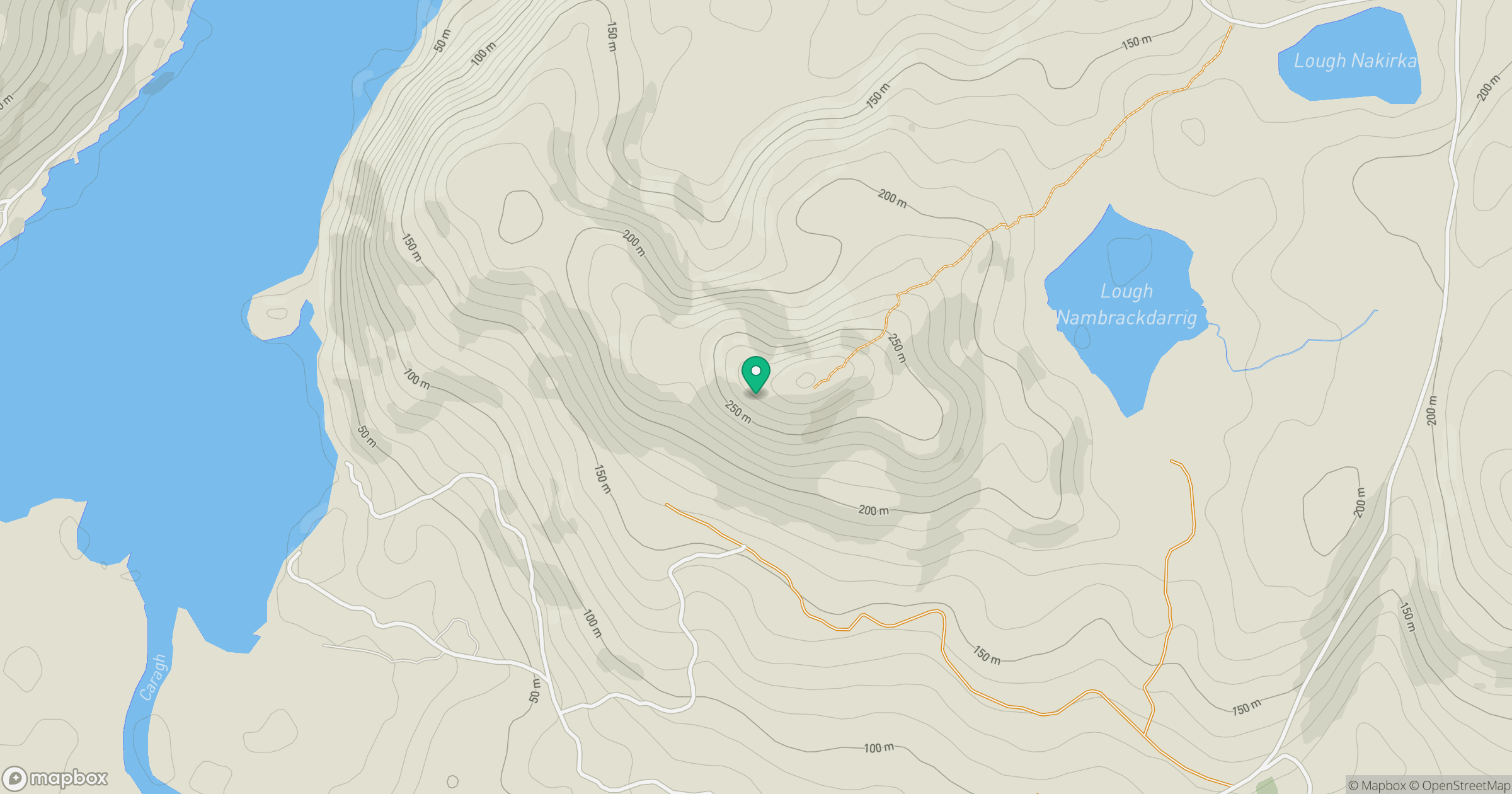
Grid reference: V721885
View on OpenStreetMapOpens a map in a new tab, centred on the hill.
Hills within 30 km
Straight-line distance, not a walking route or confirmation of access.
No comments yet. Be the first.