

Cruach Mhalaig
Good walks are even better shared.
Overview
Cruach Mhalaig
Nestled in the heart of the Scottish Highlands, Cruach Mhalaig stands tall at 651 meters, beckoning outdoor enthusiasts to explore its scenic paths and rugged beauty.
Geology
Cruach Mhalaig is primarily composed of volcanic rock, specifically basalt. Its unique geological features offer not only a stunning view but also a fascinating insight into the ancient volcanic activity that shaped this enchanting landscape. Be sure to look out for the cliff formations as you ascend!
Routes
The most popular route starts from the West Highland Way, which is renowned for its stunning vistas and ease of access. This route is approximately 8.5 km long and takes about 3.5 hours to complete, making it a great day trip.
Summit Features
Upon reaching the summit, you are greeted with a characteristic trig point and a sizeable cairn, perfect for achieving your hiking selfie goals or pondering life’s mysteries while gazing over the expanse of Loch Shiel.
Terrain Type
Expect a delightful mix of grassy trails interspersed with rocky sections. This terrain offers a few surprises, but nothing too daunting - just enough to keep the ascent interesting!
Views
The views from Cruach Mhalaig are simply unforgettable. Look out over Loch Shiel and the surrounding peaks, including the illustrious Beinn na Caillich. Late spring to early autumn is particularly ideal for stunning vistas, but if you're adventurous enough, winter sunsets are a spectacle of their own.
Hazards
Be mindful of loose rocks and sudden weather changes, as they can catch an unsuspecting hiker off guard. And don’t forget the boggy patches - keeping your feet dry is a challenge that adds an exciting twist to the adventure!
Access
The nearest parking can be found at the end of the B8043, where ample spaces await eager hikers. Public transport options are limited; however, a bus to nearby villages can help you, and local taxis are a reliable choice. Fort William, about 25 km away, is your closest town, providing access to refreshment and supplies.
Facilities
Facilities are not present on the mountain, but Fort William has an array of cafes and shops to enjoy after your hike - a perfect chance to sip a warm mug of cocoa while recounting your epic journey.
History
The name 'Cruach Mhalaig' has Gaelic origins, where 'Cruach' means 'hill' and 'Mhalaig' likely refers to 'a place of porpoises'. While there are no porpoises on the hill, this name reminds us of the area's deep-rooted history and its significance in local navigation and folklore.
So, pack your bags, grab your boots, and set forth to explore the majestic Cruach Mhalaig. Adventure awaits, and don’t forget – the mountains may be calling, but they also have a knack for hiding your keys!
Explore routes near Cruach Mhalaig
Public walks starting within 80 km of this hill. Nearby does not mean a route reaches the summit; check its map and access before setting out.
Banavie to Glen Loy Aqueduct: Neptune’s Staircase Canal Towpath
View route
Ben Nevis via Mountain Path
View route
Loch Affric full circuit from River Affric
View route
Beinn Eighe Lancaster Wreckage at Coire Mhic Fhearchair
View route
Route planning notes
These notes describe possible approaches, not verified navigable routes or permission to cross land. Check current paths, local access rules and conditions before setting out.
West Highland Way Approach
A straightforward ascent starting from a popular point on the West Highland Way, ideal for both experienced hikers and those looking for a gentle adventure.
Make a day of it, together
Find someone to share the walk with, or organise a day out along a route you like.
Photo Gallery
View all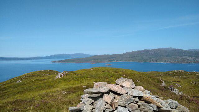 Photo could not load
NM6997 : Cruach Mhalaig
Dougie Beck
Hill facts and local notes
Classifications
Elevation
203m
666 ft
Prominence
100m
Coordinates
57.0091, -5.8017
NM692973
OS Map
40
Explorer: 398W
At the Summit
The summit features a prominent trig point and a substantial cairn, perfect for some summit selfies or contemplating life’s big questions (like 'Why did I think this was a good idea?').
Terrain & Geology
Cruach Mhalaig is primarily composed of volcanic rock, specifically basalt, which gives it its rugged appearance. This geological setting provides fascinating cliff formations and varied flora.
Views & Scenery
From the summit, you'll be rewarded with breathtaking views of Loch Shiel and the surrounding mountains, including the rugged peaks of the surrounding range.
History & Heritage
Name Origin
The name 'Cruach Mhalaig' is derived from Gaelic, with 'Cruach' meaning 'heap' or 'hill', and 'Mhalaig', possibly referring to 'a place of porpoises'. So, while you might not see any porpoises up there, you'll definitely have a 'heap' of fun!
Historical Significance
Historically, the area around Cruach Mhalaig has been home to various Celtic tribes, and it remains an important landmark for navigation and local folklore.
Getting There & Facilities
Check current local access restrictions, parking rules and transport timetables before travelling. These notes do not confirm public access to the summit.
Parking
The nearest parking is at the end of the B8043 road, where there is space for several cars. Arrive early to secure your spot, as it can fill up quickly during the tourist season.
Public Transport
There is limited public transport; however, local buses run to nearby villages where you can find a taxi service to reach the start of your hike.
Nearby Facilities
While there are no facilities near the mountain itself, Fort William offers a range of cafes, restaurants, and shops for all your pre- and post-hike needs, including hearty meals and essential supplies.
Safety Information
Known Hazards
- Loose rocks on the path, sudden weather changes, and boggy areas. It's always wise to keep an eye on the sky and your footing!
General Safety Tips
- Check weather conditions before setting out
- Carry appropriate clothing and equipment
- Let someone know your planned route
- Take a map, compass, and GPS device
- Carry emergency supplies: food, water, first aid kit, torch
Hills
Some common questions about the hills answered
Are there group walks up Cruach Mhalaig?
Many walkers use Walkmates to join or organise walks with others. You can check for group walks around Cruach Mhalaig through the maps
Are there other walkers around Cruach Mhalaig?
Activity varies by location and time, but Walkmates lets you see whether others have shared walks or shown interest in this area. Find other people through the walking friends search walking friends for Cruach Mhalaig search or of course create your own walk for Cruach Mhalaig
Can I organise a walk to Cruach Mhalaig?
Yes. If there aren’t any walks listed already, you can create a walk and make it available for others to join.
If you're signed up to Walkmates, you can create a walk to Cruach Mhalaig.
How do I find a walk up this hill?
There are often multiple ways to walk this hill, depending on experience and route preference. Walkmates helps you explore walks and routes that others have shared.
Can I suggest a new route up Cruach Mhalaig?
Yes. You can suggest or create routes to share with others. Walkmates focuses on the social side of walking, so routes are used to help people organise walks and explore areas together, rather than as detailed navigation tools or route libraries.
Other uses really appreciate knowledgeable walkers sharing their routes. Share your favourite route to Cruach Mhalaig here
The is an error or something incorrect about this hill. How do I let you know?
We always strive to keep the information on Walkmates as accurate as possible. If you find an error, please let us know through the contact form and we'll aim to correct it as quickly as possible
Community Discussion
Comments
Location
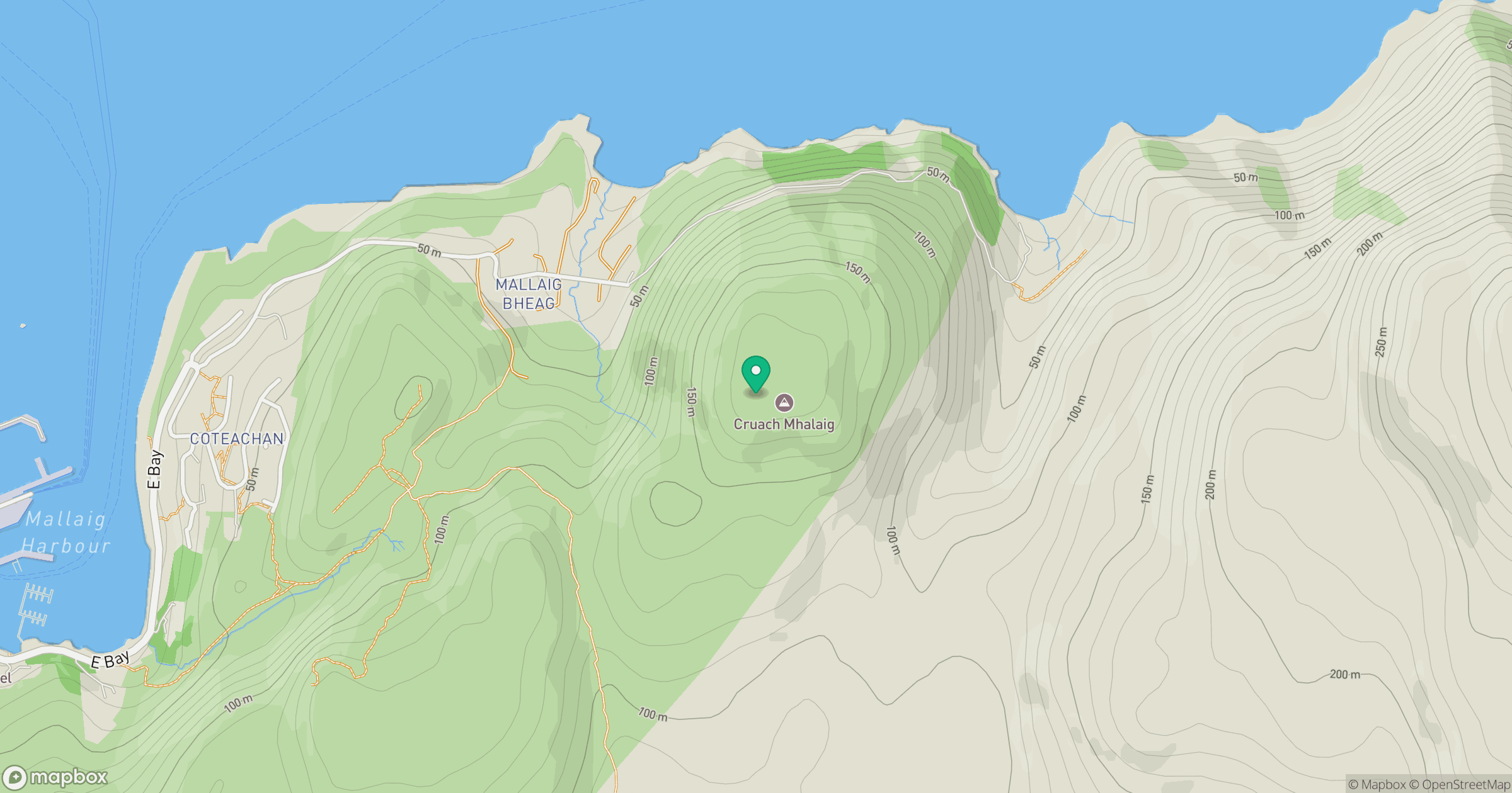
Grid reference: NM692973
View on OpenStreetMapOpens a map in a new tab, centred on the hill.
Hills within 30 km
Straight-line distance, not a walking route or confirmation of access.
Ladhar Bheinn
1,020m
Beinn Sgritheall
974m
An Caisteal
622m
Blabheinn [Bla Bheinn]
929m
Sgurr na Stri
495m
No comments yet. Be the first.