

Crieff Hill
Good walks are even better shared.
NO0343 : Woodland track near Loch of the Lowes
Alpin Stewart Photo source
Overview
Crieff Hill: An Outdoor Delight
Nestled in the heart of Central Scotland, Crieff Hill offers both novice and seasoned hikers a delightful escape into nature. With an elevation of 543 meters, this Marilyn is more than just a pretty face; it boasts some of the most rewarding views around.
Geology
Crieff Hill's landscape is characterised by its sandstone formations. These sedimentary layers tell a story of geological history and provide a solid footing as you meander towards the summit. Just be careful; while the history may be set in stone, your footing shouldn't be!
Routes
Crieff to Crieff Hill Trail
This popular route starts in Crieff and meanders through beautiful woodlands, gradually ascending to the summit. At approximately 4.5 km in length and taking around 1.5 hours to complete, it's a manageable trek for most skilful wanderers.
Summit Features
Once you reach the top, greet the trig point with a smile and admire the small stone cairn that commands the area. It’s a favourite spot for hikers to take a moment to reflect and, naturally, snap a few photos.
Terrain Type
Expect a mixed terrain of grassy slopes with some rocky outcrops. The paths are typically well-defined, but after heavy rain, the ground can get boggy—definitely a reason to invest in good waterproof footwear!
Views and Best Seasons
The summit presents spectacular panoramas of the Strathearn valley, Ben Vorlich, and even further afield on clear days. The best times to visit are spring and early autumn, when the weather is generally lovely, and the colours are vibrant. Pack a picnic; you'll likely want to linger longer than expected!
Hazards
Stay vigilant; paths can be slippery when wet, and the occasional sheep might suddenly appear to surprise you. Remember to stay on designated tracks to protect the local flora.
Nearby Summits
Crieff Hill is surrounded by other notable peaks, such as Ben Chonzie and Ben Vorlich, perfect for those itching for a more challenging adventure.
Access
Nearest Parking
A small car park is located just off the A85, making accessibility to the trailhead a breeze.
Public Transport
Crieff is well-served by public transport, with frequent bus connections from Perth and Stirling. Do check the schedules, as they can vary.
Nearest Town
Visitors will find Crieff itself to be a charming town with all the necessary amenities, including places to eat and shop.
Facilities
After conquering Crieff Hill, enjoy the quaint cafes and eateries that Crieff has to offer. It’s the perfect way to wind down after a satisfying hike, with plenty of options from hearty meals to sweet treats.
History
The name 'Crieff' roots back to the Gaelic word 'craobh', referring to trees—once abundant in the region. Historically, it served as a critical route for cattle drovers, ensuring that the area has long been a hub of activity and cultural significance.
Crieff Hill is a gem in Scotland's outdoor crown, whether you are in it for the adventure, the views, or simply a few good laughs over lunch.
Happy hiking!
Explore routes near Crieff Hill
Walks starting near this hill. Open a route to check its map, distance and full itinerary.
Unled club outing: West Drumochter/Beinn Udlamain (coach departure)
View route
Unled club outing: Glenesk (coach departure)
View route
Unled club outing: Xmas Walk - Bankfoot - Dunkeld (coach departure)
View route
Unled club outing: Angus coastal walk (coach departure)
View route
Route planning notes
These notes describe possible approaches. Check a route's map and access information when planning your walk.
Crieff to Crieff Hill Trail
A popular approach that offers pleasant woodland paths and stunning views as the elevation increases.
Make a day of it, together
Find someone to share the walk with, or organise a day out along a route you like.
Photo Gallery
View all Photo could not load
NO0343 : Woodland track near Loch of the Lowes
Alpin Stewart
 Photo could not load
NO0344 : Crieff Hill
Richard Webb
 Photo could not load
NO0344 : Tree near the summit of Crieff Hill
Richard Webb
 Photo could not load
NO0344 : Summit, Crieff Hill
Richard Webb
Hill facts and local notes
Classifications
Elevation
192m
630 ft
Prominence
57m
Coordinates
56.5784, -3.5745
NO033440
OS Map
52 53
Explorer: 379E
At the Summit
At the summit, you'll find a prominent trig point along with a small stone cairn, providing a perfect backdrop for your victorious selfie. Just be careful not to trip on the way up while striking your best pose!
Terrain & Geology
Crieff Hill is primarily composed of sedimentary rocks, with notable deposits of sandstone that contribute to its intriguing geological formations. The hill showcases classic features of the local landscape, including gentle slopes and rugged outcrops.
Views & Scenery
From the summit, enjoy panoramic vistas of the Strathearn valley, the distant Highlands, and if you squint hard enough, the silhouettes of Ben Vorlich and Loch Earn on a clear day.
History & Heritage
Name Origin
The name 'Crieff' is believed to come from the Gaelic word 'craobh', meaning 'tree', indicative of the woodland that once covered the area.
Historical Significance
Historically, the region was important for cattle droving and agriculture, and it has remained a popular destination for outdoor enthusiasts.
Getting There & Facilities
Parking
There is a small car park located off the A85 near Crieff, just a short walk from the trailhead.
Public Transport
Regular bus services operate from Perth and Stirling to Crieff. Check local timetables for the latest updates.
Nearby Facilities
Crieff offers a variety of facilities including cafes, restaurants, and public toilets. Ideal for refuelling before or after your hike!
Safety Information
Known Hazards
- Beware of slippery paths during wet weather and the occasional startled sheep. Stick to the paths to avoid eroding the delicate grassland.
General Safety Tips
- Check weather conditions before setting out
- Carry appropriate clothing and equipment
- Let someone know your planned route
- Take a map, compass, and GPS device
- Carry emergency supplies: food, water, first aid kit, torch
Hills
Some common questions about the hills answered
Are there group walks up Crieff Hill?
Many walkers use Walkmates to join or organise walks with others. You can check for group walks around Crieff Hill through the maps
Are there other walkers around Crieff Hill?
Activity varies by location and time, but Walkmates lets you see whether others have shared walks or shown interest in this area. Find other people through the walking friends search walking friends for Crieff Hill search or of course create your own walk for Crieff Hill
Can I organise a walk to Crieff Hill?
Yes. If there aren’t any walks listed already, you can create a walk and make it available for others to join.
If you're signed up to Walkmates, you can create a walk to Crieff Hill.
How do I find a walk up this hill?
There are often multiple ways to walk this hill, depending on experience and route preference. Walkmates helps you explore walks and routes that others have shared.
Can I suggest a new route up Crieff Hill?
Yes. You can suggest or create routes to share with others. Walkmates focuses on the social side of walking, so routes are used to help people organise walks and explore areas together, rather than as detailed navigation tools or route libraries.
Other uses really appreciate knowledgeable walkers sharing their routes. Share your favourite route to Crieff Hill here
The is an error or something incorrect about this hill. How do I let you know?
We always strive to keep the information on Walkmates as accurate as possible. If you find an error, please let us know through the contact form and we'll aim to correct it as quickly as possible
Community Discussion
Comments
Location
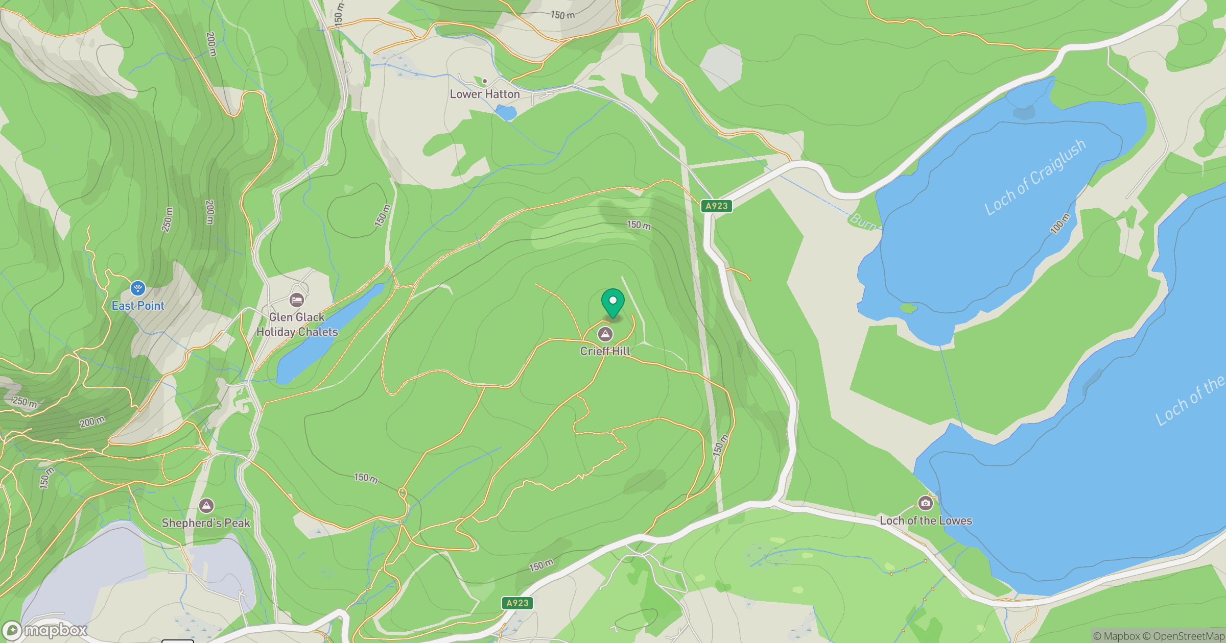
Grid reference: NO033440
View on OpenStreetMapOpens a map in a new tab, centred on the hill.
No comments yet. Be the first.