
Creag Dhubh
Good walks are even better shared.
Overview
Creag Dhubh: A Hiker's Delight
Overview
Creag Dhubh, often referred to as the 'Black Rock', stands proudly at 747 meters above sea level. This stunning Marilyn in the Scottish Highlands offers a moderate yet rewarding adventure for keen hikers seeking serenity and spectacular views.
Geology
The mountain's composition of ancient metasedimentary rocks tells a story of geological wonder, while the intrusions of igneous rock add a rugged character to the landscape. If rocks could talk, Creag Dhubh would have quite a tale to tell!
Routes
Forest Track Approach
This route is perfect for those who prefer a gentle increase in heart rate over a cliffhanger approach. Spanning 6.5 km and taking approximately 2.5 hours, this moderate hike weaves through tranquil woodland before revealing sweeping moorland vistas.
Direct Summit Ascent
For the more adventurous souls, this 4 km direct ascent is a challenging option best enjoyed with appropriate gear and a bit of grit. Allow around 1.5 hours, but don’t worry – the summit’s view at the end is the cherry on top of this strenuous cake!
Terrain
Expect a mixed bag of terrain; grassy stretches give way to rocky outcrops, with occasional boggy patches that will test your footwear's waterproof abilities. Keep an eye on the weather though; a sunny path can quickly turn into a pea soup pudding!
Views
Once at the top, feast your eyes on stunning views of the Ben Nevis range to the south and the tranquil waters of Loch Awe to the west. The best time to take in these sights? Spring and early autumn, when the landscapes are at their most vibrant.
Hazards
Common sense is your best friend while hiking. Be wary of changing weather conditions which can sometimes bring rain, wind, and mysterious Highland mists. Stick to paths where possible to avoid slip hazards on uneven terrain.
Nearby Summits
While Creag Dhubh may be a splendid stand-alone, it's often dwarfed by nearby giants such as Ben Lawers and Meall Nan Tarmachan, both offering further adventures for the intrepid hiker.
Access
Parking can be a bit of a squeeze, so plan ahead for the small lot near the forest track at NH725032. Public transport doesn't frequent this area much, but there are local coach services from nearby towns to help get you there. The nearest bustling spot is Killin, just 13 km away, where a warm café awaits after your epic trek.
Facilities
Killin offers a range of facilities, including a handful of nice cafes, restaurants, and essential public amenities. So go ahead and treat yourself to a well-deserved refreshment after your hike!
History
The name Creag Dhubh, meaning 'Black Rock', holds a symbolic significance in local heritage. This majestic mountain has inspired countless tales, folklore, and admiration through the ages, so you aren’t just hiking history, you are part of it!
In conclusion, Creag Dhubh is a gem of the Scottish Highlands. Whether you're after a gentle stroll through the woods or a challenging scramble to the summit, this mountain caters to a variety of adventurers. Just be sure to pack your sense of humour along with your sandwiches! Enjoy your hike!
Explore routes near Creag Dhubh
Public walks starting within 80 km of this hill. Nearby does not mean a route reaches the summit; check its map and access before setting out.
Aviemore: Loch an Eilein and the Croft Track from Rothiemurchus
View route
Rothiemurchus: Beaver Trail and Lochan Mor
View route
Coire Ardair lochan from Aberarder and back
View route
Great Glen Way low route: Fort Augustus to Invermoriston Old Bridge
View route
Route planning notes
These notes describe possible approaches, not verified navigable routes or permission to cross land. Check current paths, local access rules and conditions before setting out.
Forest Track Approach
A scenic path starting at the forest entrance, gradually climbing through woodland before opening up to moorland.
Direct Summit Ascent
A more challenging and direct ascent that takes you straight towards the summit from the forest track.
Make a day of it, together
Find someone to share the walk with, or organise a day out along a route you like.
Hill facts and local notes
Classifications
Elevation
787m
2,582 ft
Prominence
110m
Coordinates
57.1054, -4.1011
NH728035
OS Map
35
Explorer: OL56 402
At the Summit
The summit of Creag Dhubh boasts a large stone cairn, providing a perfect spot for a celebratory snack after the climb. On clear days, a simple trig point can also be spotted.
Terrain & Geology
Creag Dhubh is primarily composed of ancient metasedimentary rocks, giving it a rugged charm and a rich geological history. The surrounding area also features igneous intrusions that have shaped the landscape over millions of years.
Views & Scenery
From the summit, enjoy stunning vistas of the surrounding mountains including the Ben Nevis range to the south and the tranquil Loch Awe to the west.
History & Heritage
Name Origin
Creag Dhubh translates to 'Black Rock' in Gaelic, a fitting name for this imposing mountain with its darker rock formations.
Historical Significance
Historically significant for local folklore, Creag Dhubh has been a focal point for numerous stories and myths within the Highland culture.
Getting There & Facilities
Check current local access restrictions, parking rules and transport timetables before travelling. These notes do not confirm public access to the summit.
Parking
There is a small car park at the start of the forest track near NH725032, suitable for approximately 5 vehicles.
Public Transport
Public transport options are limited, but local buses from nearby towns serve the area, with Osprey Coaches providing connections to the region.
Nearby Facilities
Basic facilities can be found in Killin, including cafes, restaurants, and public toilets.
Safety Information
Known Hazards
- Watch for sudden weather changes typical of the Highlands. Also, be cautious of uneven and slippery terrain, especially in damp conditions.
General Safety Tips
- Check weather conditions before setting out
- Carry appropriate clothing and equipment
- Let someone know your planned route
- Take a map, compass, and GPS device
- Carry emergency supplies: food, water, first aid kit, torch
Hills
Some common questions about the hills answered
Are there group walks up Creag Dhubh?
Many walkers use Walkmates to join or organise walks with others. You can check for group walks around Creag Dhubh through the maps
Are there other walkers around Creag Dhubh?
Activity varies by location and time, but Walkmates lets you see whether others have shared walks or shown interest in this area. Find other people through the walking friends search walking friends for Creag Dhubh search or of course create your own walk for Creag Dhubh
Can I organise a walk to Creag Dhubh?
Yes. If there aren’t any walks listed already, you can create a walk and make it available for others to join.
If you're signed up to Walkmates, you can create a walk to Creag Dhubh.
How do I find a walk up this hill?
There are often multiple ways to walk this hill, depending on experience and route preference. Walkmates helps you explore walks and routes that others have shared.
Can I suggest a new route up Creag Dhubh?
Yes. You can suggest or create routes to share with others. Walkmates focuses on the social side of walking, so routes are used to help people organise walks and explore areas together, rather than as detailed navigation tools or route libraries.
Other uses really appreciate knowledgeable walkers sharing their routes. Share your favourite route to Creag Dhubh here
The is an error or something incorrect about this hill. How do I let you know?
We always strive to keep the information on Walkmates as accurate as possible. If you find an error, please let us know through the contact form and we'll aim to correct it as quickly as possible
Community Discussion
Comments
Location
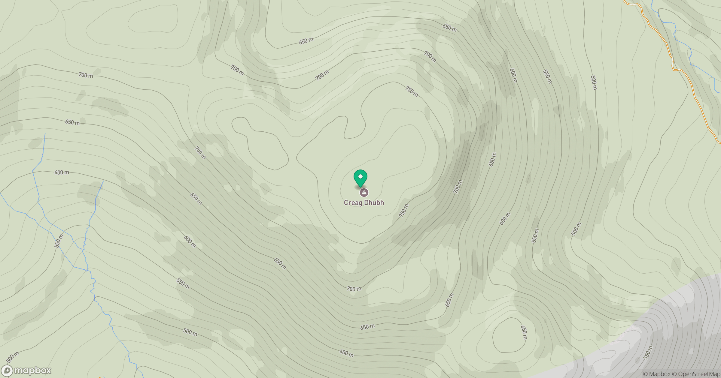
Grid reference: NH728035
View on OpenStreetMapOpens a map in a new tab, centred on the hill.
Hills within 30 km
Straight-line distance, not a walking route or confirmation of access.
No comments yet. Be the first.