

Cotracloghy
Good walks are even better shared.
Overview
Cotracloghy: A Jewel in the Scottish Highlands
Nestled amidst the stunning backdrop of the Scottish Highlands, Cotracloghy is a charming mountain that combines natural beauty with a touch of adventure. With an elevation of 615 meters, it's not the highest peak around, but it certainly packs a punch with its views and geological wonders.
Geology
Cotracloghy presents a fascinating array of granite and schist rocks. The geological formations tell tales of ancient volcanic activity and glacial movements that have shaped the landscape over millennia. The rugged rocks create a beautiful contrast with the lush vegetation, making for an unforgettable hike.
The Hiking Experience
The most popular route is the Cotracloghy Ridge Trail, a moderate 12.5 km trek that typically takes about 4.5 hours. As you ascend, you'll weave through vibrant woodlands and encounter delightful wildlife. Just don’t forget to say hello to the sheep; they are the true locals!
Summit Features
Upon reaching the summit, hikers are greeted with a large stone cairn and a trig point. Take a moment to soak in the breathtaking views of Loch Lomond and the surrounding peaks of the Trossachs National Park. It's a brilliant spot to snap a few pictures and maybe share that one inspirational quote you saved for just this moment.
Terrain Type
Expect rocky paths combined with grassy patches, providing a balance of challenge and comfort. It's like a scenic walk through nature's playground.
Views
From the top, the vistas are nothing short of spectacular. On a clear day, the shimmering waters of Loch Lomond will steal your heart. Spring and autumn are particularly beautiful times to visit, as you can enjoy the delightful colours without the pesky midges of summer!
Hazards
While the hike is manageable, do be aware of the rocky terrain which can lead to a twist of an ankle if you’re not careful. Be sure to wear proper footwear and always keep an eye on the local weather – it can change faster than you can say 'scotch whisky'.
Access
Starting your adventure is simple! Park in the small parking area at Rowardennan or take the local bus which stops conveniently nearby. The nearest town, Drymen, is just a short ride away and steeped in Scottish charm.
Facilities
Before you set off, you can grab some food or use the toilets at the cafe in Rowardennan. It's always good to have a caffeine fix before an adventure.
A Touch of History
The name Cotracloghy, reminiscent of heather, gives a nod to the flowering plants abundant on the slopes. Historically, this area has been a trade route for generations, connecting the stories and cultures of the Highlands.
In conclusion, Cotracloghy may not be the tallest mountain in the Highlands, but it certainly offers a perfect blend of stunning views, intriguing geology, and a good dose of Scottish history. Grab your boots, and go explore this hidden gem!
Explore routes near Cotracloghy
Public walks starting within 80 km of this hill. Nearby does not mean a route reaches the summit; check its map and access before setting out.
Silent Valley to Ben Crom Dam: Reservoir Road Walk, County Down
View route
Scarva to Poyntzpass: Newry Canal and Lough Shark Return
View route
Tollymore Forest Park: Mountain and Drinns Trail
View route
Tollymore Forest Park: River Trail near Newcastle
View route
Route planning notes
These notes describe possible approaches, not verified navigable routes or permission to cross land. Check current paths, local access rules and conditions before setting out.
Cotracloghy Ridge Trail
A scenic route that offers panoramic views and an enjoyable hike. This route starts from the nearby village and weaves through lush forests before ascending to the summit.
Make a day of it, together
Find someone to share the walk with, or organise a day out along a route you like.
Photo Gallery
View all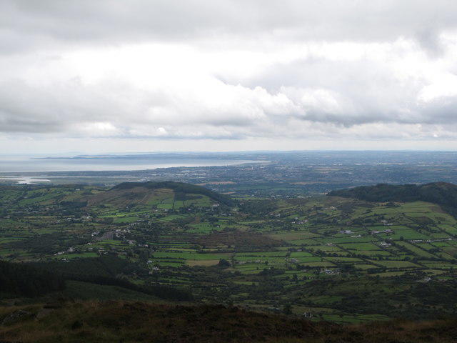 Photo could not load
J0314 : Cofracloghy/Daaikilmore and Tievecrom Mountains from Slieve Gullion
Eric Jones
Hill facts and local notes
Classifications
Elevation
225m
738 ft
Prominence
110m
Coordinates
54.0719, -6.4136
J039148
OS Map
29 36
At the Summit
The summit is marked by a large stone cairn and a small trig point, perfect for a photo op or a moment of reflection, preferably after a bit of deep breathing from the climb.
Terrain & Geology
Cotracloghy is primarily composed of granite and schist, which provide a rugged yet picturesque landscape. The rocks tell a story of ancient mountain-building processes and glaciation.
Views & Scenery
From the summit, you can see the shimmering waters of Loch Lomond and the distant peaks of the Trossachs National Park. On a clear day, the visibility is astounding, making it a superb spot for landscape photography.
History & Heritage
Name Origin
The name Cotracloghy is thought to derive from the Gaelic 'Cothraichean', meaning 'the place of the heather', but don't quote me on the heather!
Historical Significance
The area is rich in history, with ancient paths used by shepherds and traders for centuries. The Highland Way runs nearby, connecting the culture and stories of the region.
Getting There & Facilities
Check current local access restrictions, parking rules and transport timetables before travelling. These notes do not confirm public access to the summit.
Parking
There is a small parking area in the village of Rowardennan, which is about 5 km from the trailhead. Arrive early, as parking is limited!
Public Transport
The nearest bus stop is in Rowardennan; check local schedules as services may vary, especially in the off-season.
Nearby Facilities
Rowardennan offers a cafe and a public toilet, perfect for pre-hike refreshments and last-minute necessities.
Safety Information
Known Hazards
- Rocky terrain can lead to twists and turns on the route; be sure to wear sturdy boots. Watch out for sudden weather changes typical of the Highlands.
General Safety Tips
- Check weather conditions before setting out
- Carry appropriate clothing and equipment
- Let someone know your planned route
- Take a map, compass, and GPS device
- Carry emergency supplies: food, water, first aid kit, torch
Hills
Some common questions about the hills answered
Are there group walks up Cotracloghy?
Many walkers use Walkmates to join or organise walks with others. You can check for group walks around Cotracloghy through the maps
Are there other walkers around Cotracloghy?
Activity varies by location and time, but Walkmates lets you see whether others have shared walks or shown interest in this area. Find other people through the walking friends search walking friends for Cotracloghy search or of course create your own walk for Cotracloghy
Can I organise a walk to Cotracloghy?
Yes. If there aren’t any walks listed already, you can create a walk and make it available for others to join.
If you're signed up to Walkmates, you can create a walk to Cotracloghy.
How do I find a walk up this hill?
There are often multiple ways to walk this hill, depending on experience and route preference. Walkmates helps you explore walks and routes that others have shared.
Can I suggest a new route up Cotracloghy?
Yes. You can suggest or create routes to share with others. Walkmates focuses on the social side of walking, so routes are used to help people organise walks and explore areas together, rather than as detailed navigation tools or route libraries.
Other uses really appreciate knowledgeable walkers sharing their routes. Share your favourite route to Cotracloghy here
The is an error or something incorrect about this hill. How do I let you know?
We always strive to keep the information on Walkmates as accurate as possible. If you find an error, please let us know through the contact form and we'll aim to correct it as quickly as possible
Community Discussion
Comments
Location
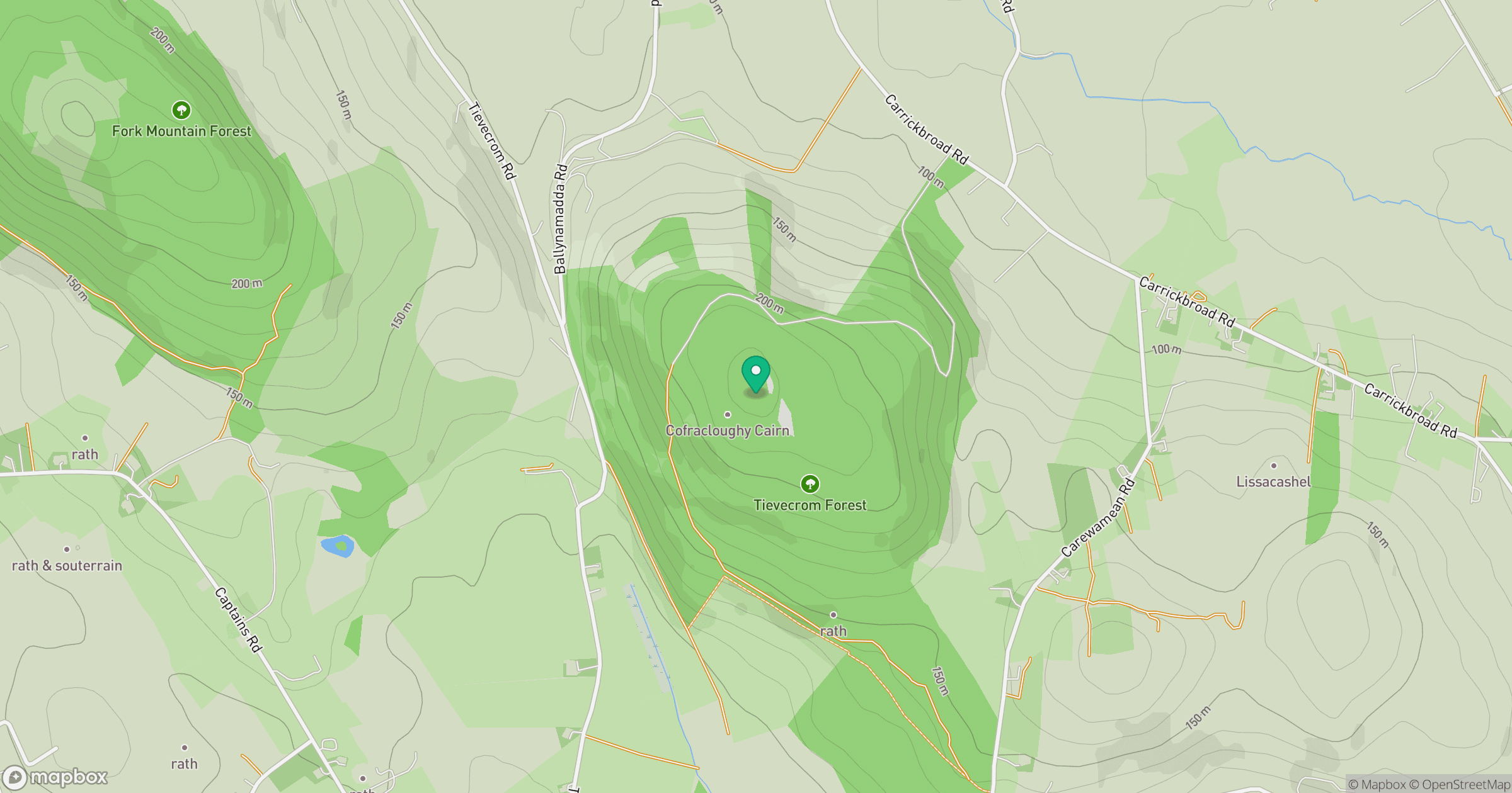
Grid reference: J039148
View on OpenStreetMapOpens a map in a new tab, centred on the hill.
Hills within 30 km
Straight-line distance, not a walking route or confirmation of access.
No comments yet. Be the first.